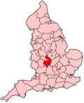
Stratford-on-Avon (district)
Stratford-on-Avon is een district in shire-graafschap (non-metropolitan county OF county) Warwickshire en telt 128.000 inwoners. Hoofdplaats is Stratford-upon-Avon.
| Niet-metropolitaans district in Engeland | |||
|---|---|---|---|
 
| |||
| Situering | |||
| Land | Engeland | ||
| County | Warwickshire | ||
| Regio | West Midlands | ||
| Coördinaten | 52°11'25"NB, 1°42'31"WL | ||
| Algemeen | |||
| Oppervlakte | 977,8694[1] km² | ||
| Inwoners (2018[2]) |
127.580 (130 inw./km²) | ||
| ONS-code | E07000221 | ||
| Website | Officiële website | ||
| Detailkaart | |||

| |||
| |||
Civil parishes in district Stratford-on-Avon
bewerkenAdmington, Alcester, Alderminster, Arrow with Weethley, Aston Cantlow, Atherstone on Stour, Avon Dassett, Barcheston, Barton-on-the-Heath, Bearley, Beaudesert, Bidford-on-Avon, Billesley, Binton, Bishop's Itchington, Brailes, Burmington, Burton Dassett, Butlers Marston, Chadshunt, Chapel Ascote, Charlecote, Cherington, Chesterton and Kingston, Claverdon, Clifford Chambers and Milcote, Combrook, Compton Verney, Compton Wynyates, Coughton, Dorsington, Ettington, Exhall, Farnborough, Fenny Compton, Fulbrook, Gaydon, Great Alne, Great Wolford, Halford, Hampton Lucy, Harbury, Haselor, Henley-in-Arden, Hodnell and Wills Pastures, Honington, Idlicote, Ilmington, Kineton, Kinwarton, Ladbroke, Langley, Lighthorne, Lighthorne Heath, Little Compton, Little Wolford, Long Compton, Long Itchington, Long Marston, Loxley, Luddington, Mappleborough Green, Moreton Morrell, Morton Bagot, Napton on the Hill, Newbold Pacey, Old Stratford and Drayton, Oldberrow, Oxhill, Pillerton Hersey, Pillerton Priors, Pillerton Priors, Preston on Stour, Priors Hardwick, Priors Marston, Quinton, Radbourn, Radway, Ratley and Upton, Salford Priors, Sambourne, Shipston on Stour, Shotteswell, Snitterfield, Southam, Spernall, Stockton, Stoneton, Stoneton, Stratford-upon-Avon, Stretton-on-Fosse, Studley, Sutton-under-Brailes, Tanworth-in-Arden, Temple Grafton, Tidmington, Tredington, Tysoe, Ufton, Ullenhall, Upper and Lower Shuckburgh, Warmington, Watergall, Welford-on-Avon, Wellesbourne, Weston-on-Avon, Whatcote, Whichford, Whitchurch, Wilmcote, Wixford, Wolverton, Wootton Wawen, Wormleighton.
- ↑ Office for National Statistics → Download → SAM_for_Administrative_Areas_(2018).zip → SAM_LAD_DEC_2018_UK.xlsx.
- ↑ https://www.ons.gov.uk/file?uri=/peoplepopulationandcommunity/populationandmigration/populationestimates/datasets/populationestimatesforukenglandandwalesscotlandandnorthernireland/mid20182019laboundaries/ukmidyearestimates20182019ladcodes.xls Schatting Office for National Statistics: knop MYE5 → kolom Estimated Population mid-2018]