Bestand:Oettingen Counties 1744.png

Grootte van deze voorvertoning: 636 × 600 pixels. Andere resoluties: 254 × 240 pixels | 509 × 480 pixels | 814 × 768 pixels | 1.086 × 1.024 pixels | 2.171 × 2.048 pixels | 3.664 × 3.456 pixels.
Oorspronkelijk bestand (3.664 × 3.456 pixels, bestandsgrootte: 26,53 MB, MIME-type: image/png)
| Dit is een bestand van Wikimedia Commons. Onderstaande beschrijving komt van de beschrijving van het bestand daar. |
Beschrijving
| Beschrijving |
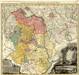
English: Map showing the territories of the House of Oettingen in the mid-18th century: the Principality of Oettingen (or Oettingen-Spielberg, in pink) and the Counties of Oettingen-Oettingen (light yellow), Oettingen-Baldern (aqua) and Oettingen-Wallerstein (yellow). Also shown (in purple) are the territories of the free imperial cities of Nördlingen (with its half-dozen exclaves), Bopfingen and Dinkelsbühl. The map, which contains information in Latin, French and German, was designed by M. F. Cnopf and published by Homann Erben (Homann Heirs) in 1744. |
| Datum | |
| Bron | Moll's map collection |
| Auteur | M. F. Cnopf - Homann Heirs |
Licentie
|
Dit werk bevindt zich in het publiek domein in landen en gebieden waar de auteursrechttermijn het leven van de auteur plus 100 jaar of minder is. | |
| Van dit bestand is vastgesteld dat er geen bekende auteursrechtaanspraken op rusten, alle aanverwante en naburige rechten daarbij inbegrepen. | |
Bestandsgeschiedenis
Klik op een datum/tijd om het bestand te zien zoals het destijds was.
| Datum/tijd | Miniatuur | Afmetingen | Gebruiker | Opmerking | |
|---|---|---|---|---|---|
| huidige versie | 3 jul 2018 01:39 | | 3.664 × 3.456 (26,53 MB) | Lubiesque | User created page with UploadWizard |
Bestandsgebruik
Dit bestand wordt op de volgende pagina gebruikt:
Globaal bestandsgebruik
De volgende andere wiki's gebruiken dit bestand:
- Gebruikt op cs.wikipedia.org
- Gebruikt op de.wikipedia.org
- Gebruikt op de.wikisource.org
- Gebruikt op en.wikipedia.org
- Gebruikt op he.wikipedia.org
- Gebruikt op ru.wikipedia.org