Bestand:Austria 1945-55.png

Grootte van deze voorvertoning: 800 × 310 pixels. Andere resoluties: 320 × 124 pixels | 640 × 248 pixels | 1.400 × 542 pixels.
Oorspronkelijk bestand (1.400 × 542 pixels, bestandsgrootte: 60 kB, MIME-type: image/png)
| Dit is een bestand van Wikimedia Commons. Onderstaande beschrijving komt van de beschrijving van het bestand daar. |
Beschrijving
| Beschrijving |
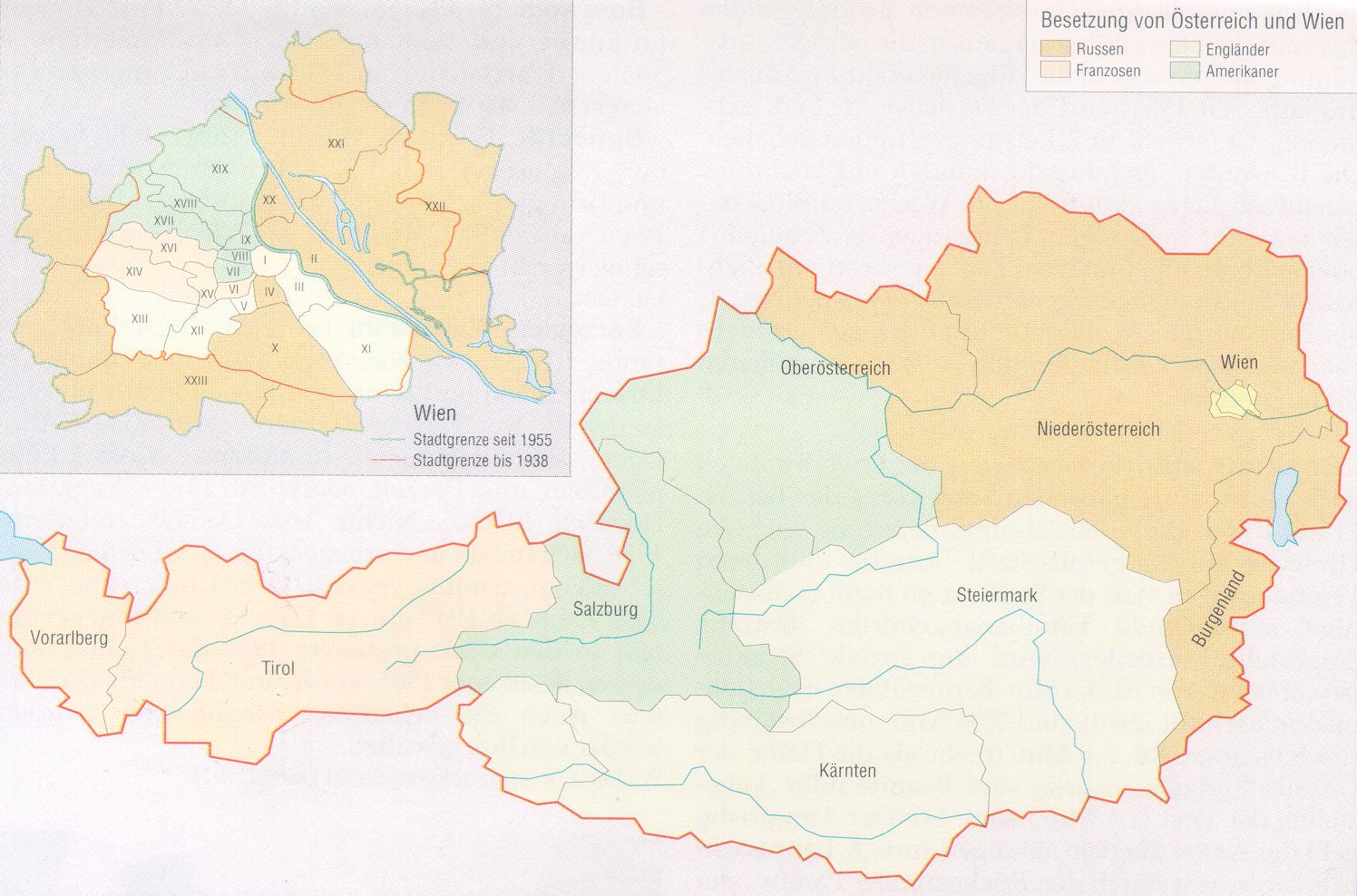
English: Occupied zones in Austria, 1945–1955.
Deutsch: Besatzungszonen in Österreich, 1945–1955.
Español: Zonas ocupadas por los aliados en Austria, 1945–1955.
Português: Zonas ocupadas pelos aliados na Áustria, 1945–1955.
Русский: Оккупационные зоны в Австрии, 1945–1955.
Български: Окупационни зони в Австрия, 1945–1955. |
| Datum | |
| Bron | Original version |
| Auteur |
Original by C.Lingg last update by Gugganij |

|
Bestand:Austria Occupation Zones 1945-55.svg is een vectorversie van dit bestand. Indien niet van slechtere kwaliteit dient deze gebruikt te worden in plaats van deze rasterafbeelding.
File:Austria 1945-55.png → File:Austria Occupation Zones 1945-55.svg
Zie Help:SVG voor meer informatie. |
 |
Licentie
| Ik, de auteursrechthebbende van dit werk, geef dit werk vrij in het publieke domein. Dit is wereldwijd van toepassing. In sommige landen is dit wettelijk niet mogelijk; in die gevallen geldt: Ik sta iedereen toe dit werk voor eender welk doel te gebruiken, zonder enige voorwaarden, tenzij zulke voorwaarden door de wet worden voorgeschreven. |
| Aantekeningen | Deze afbeelding is aangetekend: Bekijk de aantekeningen op Commons |

Bestandsgeschiedenis
Klik op een datum/tijd om het bestand te zien zoals het destijds was.
| Datum/tijd | Miniatuur | Afmetingen | Gebruiker | Opmerking | |
|---|---|---|---|---|---|
| huidige versie | 9 nov 2009 00:18 | 1.400 × 542 (60 kB) | Gugganij | corrected colours of Vienna | |
| 13 sep 2008 18:13 | 1.400 × 542 (80 kB) | IJA | Changed UK areas to green from the previous horrid brown/ grey colour. Looks better now and it also corresponds with the German Occupation zone version. | ||
| 26 apr 2008 16:43 | 1.400 × 542 (80 kB) | Möchtegern | Occupied zones in Austria, 1945-1955 drawn by Christoph Lingg, 21.08.2005 {{PD-self}} {{SVG|map}} Category:Maps of the history of Austria | ||
| 14 okt 2007 15:56 | 1.400 × 542 (59 kB) | C.lingg | Fixed the american flag. it contains now 48 stars. | ||
| 21 aug 2005 19:13 | 1.400 × 542 (58 kB) | C.lingg | Occupied Austria, 1945-1955. selfmade, source: http://www.aeiou.at/aeiou.encyclop.data.image.b/b397245b.jpg {{PD}} | ||
| 29 jul 2005 15:04 |  | 1.500 × 1.027 (128 kB) | Karl Gruber | map colored by myself 7/2005 | |
| 29 jul 2005 07:27 |  | 1.490 × 771 (6 kB) | Phrood~commonswiki | GFDL, drawn by Kagru, converted to png by Phrood |
Bestandsgebruik
Dit bestand wordt op de volgende 5 pagina's gebruikt:
Globaal bestandsgebruik
De volgende andere wiki's gebruiken dit bestand:
- Gebruikt op bs.wikipedia.org
- Gebruikt op ca.wikipedia.org
- Gebruikt op cs.wikipedia.org
- Gebruikt op cy.wikipedia.org
- Gebruikt op da.wikipedia.org
- Gebruikt op de.wikipedia.org
- Gebruikt op en.wikipedia.org
- Gebruikt op eo.wikipedia.org
- Gebruikt op et.wikipedia.org
- Gebruikt op fr.wikipedia.org
- Histoire de l'Autriche
- Anschluss
- Traité d'État autrichien
- Portail:Autriche
- Portail:Autriche/Histoire
- Occupation de l'Autriche après la Seconde Guerre mondiale
- Discussion:Occupation de l'Autriche après la Seconde Guerre mondiale
- Wikipédia:Le saviez-vous ?/Archives/2014
- Utilisateur:GhosterBot/BacASable/testStat bis/Visibilité des anecdotes (2014)
- Utilisateur:GhosterBot/BacASable/testStat b/Visibilité des anecdotes (2014)
- Utilisateur:GhosterBot/BacASable/testStat/Visibilité des anecdotes (2014)
- Wikipédia:Statistiques des anecdotes de la page d'accueil/Visibilité des anecdotes (2014)
- Wikipédia:Statistiques des anecdotes de la page d'accueil/Visibilité des anecdotes (2014)/2014 12
- Discussion:Kalash (peuple)/LSV 20378
- Gebruikt op he.wikipedia.org
- Gebruikt op hr.wikipedia.org
- Gebruikt op hu.wikipedia.org
- Gebruikt op hy.wikipedia.org
- Gebruikt op is.wikipedia.org
- Gebruikt op it.wikipedia.org
- Gebruikt op ka.wikipedia.org
- Gebruikt op lt.wikipedia.org
- Gebruikt op lv.wikipedia.org
- Gebruikt op no.wikipedia.org
- Gebruikt op pt.wikipedia.org
- Gebruikt op ro.wikipedia.org
- Gebruikt op ru.wikipedia.org
- Gebruikt op sh.wikipedia.org
- Gebruikt op sl.wikipedia.org
- Gebruikt op sv.wikipedia.org
Globaal gebruik van dit bestand bekijken.