Bestand:XXth Century Citizen's Atlas map of Central Asia.png
Grootte van deze voorvertoning: 800 × 566 pixels. Andere resoluties: 320 × 227 pixels | 640 × 453 pixels | 1.024 × 725 pixels | 1.280 × 906 pixels | 2.548 × 1.804 pixels.
Oorspronkelijk bestand (2.548 × 1.804 pixels, bestandsgrootte: 7,49 MB, MIME-type: image/png)
| Dit is een bestand van Wikimedia Commons. Onderstaande beschrijving komt van de beschrijving van het bestand daar. |
| Beschrijving | |
| Datum | |
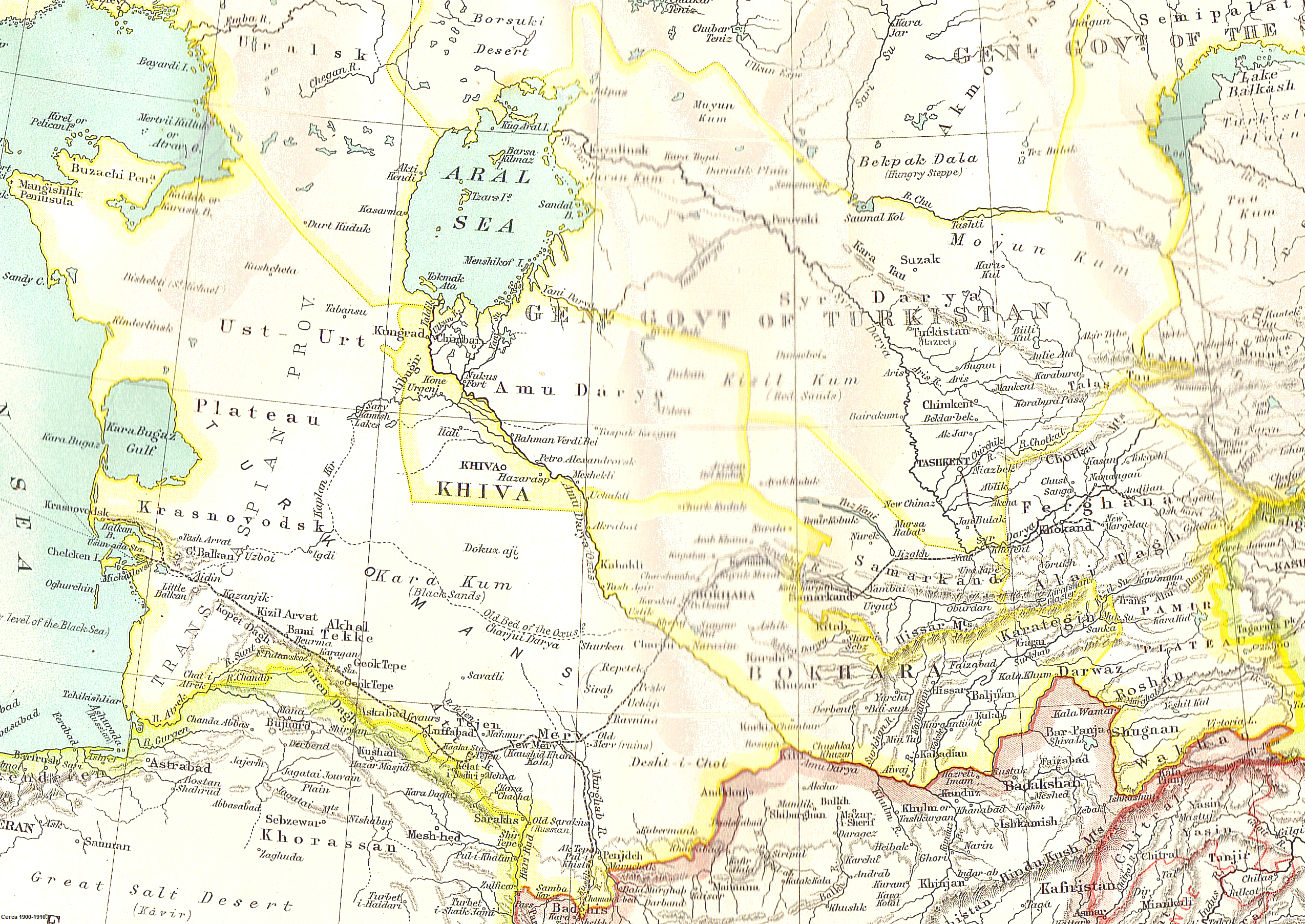
| Bron | Scanned from John Bartholomew's XXth Century Citizen's Atlas (1903) |
| Auteur | Uncertain: either John George Bartholomew or an unknown employee |
| Toestemming (Hergebruik van dit bestand) |
If this were produced by Bartholomew himself, it is {{PD-UK-known}}, because Bartholomew died in 1920. If it were produced by an anonymous employee, it is {{PD-UK-unknown}}, because it is an anonymous artistic work other than a photograph, which was made available to the public before 1 January 1940. Either way, it is public domain in the United Kingdom, the country of origin. Published before 1923, it is also public domain in the United States. |
Dit mediabestand is in het publiek domein in de Verenigde Staten van Amerika. Dit geldt voor werken uit de VS waarvan de copyright is verlopen, meestal omdat de eerste publicatie ervan verscheen voor 1 januari 1929. Zie ook deze pagina voor verdere uitleg
|
 | |
 |
Let op! Dit bestand hoeft niet in het publiek domein te zijn buiten de VS (dit geldt voor Canada, China (excl. Hong Kong, Macao of Taiwan), Duitsland, Mexico en Zwitserland). De auteur en het jaar van publicatie zijn essentiële informatie en moeten zijn vastgesteld. Zie ook Wikipedia:Public domain en Wikipedia:Copyrights voor meer informatie.
|
Bestandsgeschiedenis
Klik op een datum/tijd om het bestand te zien zoals het destijds was.
| Datum/tijd | Miniatuur | Afmetingen | Gebruiker | Opmerking | |
|---|---|---|---|---|---|
| huidige versie | 6 mei 2010 14:18 | | 2.548 × 1.804 (7,49 MB) | Nyttend | {{Information |Description = A map of Central Asia |Source = Scanned from [http://catalogue.nla.gov.au/Record/2532586 John Bartholomew's ''XXth Century Citizen's Atlas'' (1903)] |Date = 1903 |Author = Uncertain: either John George Bartholomew or an un |
Bestandsgebruik
Dit bestand wordt op de volgende pagina gebruikt:
Globaal bestandsgebruik
De volgende andere wiki's gebruiken dit bestand:
- Gebruikt op ar.wikipedia.org
- Gebruikt op azb.wikipedia.org
- Gebruikt op bg.wikipedia.org
- Gebruikt op bn.wikipedia.org
- Gebruikt op da.wikipedia.org
- Gebruikt op de.wikipedia.org
- Gebruikt op el.wikipedia.org
- Gebruikt op en.wikipedia.org
- Khwarazm
- Russian Turkestan
- Khanate of Kokand
- Khanate of Khiva
- Soviet Central Asia
- User:John Q. A. Geadon
- Uzboy
- Arys (river)
- User talk:Snow storm in Eastern Asia/Archive pictures 2
- User talk:Its snowing in East Asia/Archive pictures 0
- User talk:Its snowing in East Asia/Archive pictures 1
- User talk:Its snowing in East Asia/Archive pictures 2
- Foreign policy of the Russian Empire
- User:Falcaorib
- Gebruikt op es.wikipedia.org
- Gebruikt op et.wikipedia.org
- Gebruikt op fa.wikipedia.org
- Gebruikt op fi.wikipedia.org
- Gebruikt op he.wikipedia.org
- Gebruikt op it.wikipedia.org
- Gebruikt op ka.wikipedia.org
- Gebruikt op kk.wikipedia.org
- Gebruikt op ko.wikipedia.org
- Gebruikt op lv.wikipedia.org
- Gebruikt op no.wikipedia.org
Globaal gebruik van dit bestand bekijken.