Bestand:World Night Lights Map.jpg
Grootte van deze voorvertoning: 800 × 332 pixels. Andere resoluties: 320 × 133 pixels | 917 × 380 pixels.
Oorspronkelijk bestand (917 × 380 pixels, bestandsgrootte: 33 kB, MIME-type: image/jpeg)
| Dit is een bestand van Wikimedia Commons. Onderstaande beschrijving komt van de beschrijving van het bestand daar. |

|
Dit bestand kan vervangen worden door File:Earthlights dmsp.jpg. Het wordt aangeraden om het andere bestand te gebruiken. Opmerking: dit bestand zal niet worden verwijderd tenzij het expliciet wordt genomineerd ter verwijdering.
|
| Beschrijving |
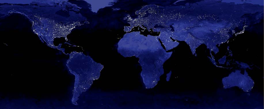
English: The image shows the urbanization of the world's cities through the use of the DMSP satellite system. This image of Earth's city lights was created with data from the Defense Meteorological Satellite Program (DMSP) Operational Linescan System (OLS). Originally designed to view clouds by moonlight, the OLS is also used to map the locations of permanent lights on the Earth's surface. The brightest areas of the Earth are the most urbanized, but not necessarily the most populated. (Compare western Europe with China and India.) Cities tend to grow along coastlines and transportation networks. The United States interstate highway system appears as a lattice connecting the brighter dots of city centers. In Russia, the Trans-Siberian railroad is a thin line stretching from Moscow through the center of Asia to Vladivostok. The Nile River, from the Aswan Dam to the Mediterranean Sea, is another bright thread through an otherwise dark region. Even more than 100 years after the invention of the electric light, some regions remain thinly populated and unlit. Antarctica is entirely dark. The interior jungles of Africa and South America are mostly dark, but lights are beginning to appear there. Deserts in Africa, Arabia, Australia, Mongolia, and the United States are poorly lit as well (except along the coast), along with the boreal forests of Canada and Russia, and the great mountains of the Himalaya. |
||
| Datum | |||
| Bron | Imagery by NASA and/or the US Geological Survey. Processed by Terra Prints Inc. | ||
| Auteur |
Data courtesy Marc Imhoff of NASA GSFC and Christopher Elvidge of NOAA NGDC. |
||
| Toestemming (Hergebruik van dit bestand) |
Own work, share alike, attribution required (Creative Commons CC-BY-SA-2.5) |
||
| Andere versies |
|
.jpg)
Ik, de auteursrechthebbende van dit werk, maak het hierbij onder de volgende licentie beschikbaar:
Dit bestand is gelicenseerd onder de Creative Commons-licentie Naamsvermelding-Gelijk delen 2.5 Unported
- De gebruiker mag:
- Delen – het werk kopiëren, verspreiden en doorgeven
- Remixen – afgeleide werken maken
- Onder de volgende voorwaarden:
- naamsvermelding – U moet op een gepaste manier aan naamsvermelding doen, een link naar de licentie geven, en aangeven of er wijzigingen in het werk zijn aangebracht. U mag dit op elke redelijke manier doen, maar niet zodanig dat de indruk wordt gewekt dat de licentiegever instemt met uw werk of uw gebruik van zijn werk.
- Gelijk delen – Als u het werk heeft geremixt, veranderd, of erop heeft voortgebouwd, moet u het gewijzigde materiaal verspreiden onder dezelfde licentie als het oorspronkelijke werk, of een daarmee compatibele licentie.
Bestandsgeschiedenis
Klik op een datum/tijd om het bestand te zien zoals het destijds was.
| Datum/tijd | Miniatuur | Afmetingen | Gebruiker | Opmerking | |
|---|---|---|---|---|---|
| huidige versie | 22 feb 2009 22:09 | | 917 × 380 (33 kB) | Cropbot | upload cropped version, operated by User:Finavon. Summary: caption/border cropped |
| 22 okt 2006 05:37 |  | 1.000 × 500 (46 kB) | Rolandc73 | {{Information |Description=Imagery by NASA and/or the US Geological Survey. Processed by Terra Prints Inc. The image shows the urbanization of the world's cities through the use of the DMSP satellite system. This image of Earth's city lights was created w |
Bestandsgebruik
Dit bestand wordt op de volgende pagina gebruikt:
Globaal bestandsgebruik
De volgende andere wiki's gebruiken dit bestand:
- Gebruikt op en.wikipedia.org
- User talk:ReverendG/Archive
- User talk:Tonywalton/Dec-2006
- User talk:ProveIt
- User talk:The Transhumanist/Archive 2
- User talk:Jimbo Wales/Archive 15
- User talk:Iwazaki/Archive 1
- User talk:Renamed user 5417514488/archive 8
- User:NinaOdell/My sandbox
- User talk:Bearly541/Archive3
- User talk:Just H/Archive 2
- User talk:Khoikhoi/Archive 23
- User talk:Sam/Archive 7
- User talk:Itsmejudith/Archive 3
- Wikipedia talk:WikiProject Religion/Archive 2
- User talk:Herostratus/Archive 2