Bestand:WielkoPolska epoki Piastowskiej.jpg

Oorspronkelijk bestand (4.075 × 3.613 pixels, bestandsgrootte: 10,46 MB, MIME-type: image/jpeg)
| Dit is een bestand van Wikimedia Commons. Onderstaande beschrijving komt van de beschrijving van het bestand daar. |
Beschrijving
| Beschrijving |
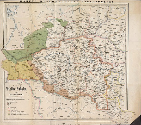
English: Historical map of Greater Poland (Middle Ages) made by Dr. T. Szulc and included in the 4th volume of Codex diplomaticus Maioris Poloniae
Polski: Historyczna mapa Wielkopolski w epoce piastowskiej wykonana przez Dr. T. Szulca i zamieszczona w 4. tomie Kodeksu dyplomatycznego Wielkopolski |
| Datum | |
| Bron | Kodeks dyplomatyczny Wielkopolski obejmujący dokumenta tak już drukowane, jak dotąd nie ogłoszone, sięgające do roku 1400, t.4, Poznań 1881 - Mapa Wielkopolski |
| Auteur | Dr. T. Szulc |
| Andere versies | Afgeleide werken van dit bestand: Land given up to Silesian dukes (Dr. T. Szulc).jpg |
.jpg)
Licentie
|
Dit werk bevindt zich in het publiek domein in landen en gebieden waar de auteursrechttermijn het leven van de auteur plus 70 jaar of minder is.
| |
| Van dit bestand is vastgesteld dat er geen bekende auteursrechtaanspraken op rusten, alle aanverwante en naburige rechten daarbij inbegrepen. | |
Bestandsgeschiedenis
Klik op een datum/tijd om het bestand te zien zoals het destijds was.
| Datum/tijd | Miniatuur | Afmetingen | Gebruiker | Opmerking | |
|---|---|---|---|---|---|
| huidige versie | 22 jun 2009 17:28 | | 4.075 × 3.613 (10,46 MB) | Paelius | {{Information |Description={{en|1=Historical map of Greater Poland (Middle Ages) made by Dr. T. Szulc and included in the 4th volume of Codex diplomaticus Maioris Poloniae}} {{pl|1=Historyczna mapa Wielkopolski w epoce piastowskiej wykonana przez Dr. T. S |
Bestandsgebruik
Dit bestand wordt op de volgende pagina gebruikt:
Globaal bestandsgebruik
De volgende andere wiki's gebruiken dit bestand:
- Gebruikt op azb.wikipedia.org
- Gebruikt op bg.wikipedia.org
- Gebruikt op ca.wikipedia.org
- Gebruikt op cs.wikipedia.org
- Gebruikt op da.wikipedia.org
- Gebruikt op de.wikipedia.org
- Gebruikt op dsb.wikipedia.org
- Gebruikt op el.wikipedia.org
- Gebruikt op en.wikipedia.org
- Gebruikt op es.wikipedia.org
- Gebruikt op et.wikipedia.org
- Gebruikt op fa.wikipedia.org
- Gebruikt op hr.wikipedia.org
- Gebruikt op mk.wikipedia.org
- Gebruikt op no.wikipedia.org
- Gebruikt op pl.wikipedia.org
- Piła (miasto)
- Głogów
- Wielkopolska
- Jarocin
- Sieraków
- Władysław Odonic
- Bolesław Pobożny
- Lubusz
- Chwarszczany
- Nowa Marchia
- Międzyrzecz
- Świebodzin
- Wschowa
- Łagów (powiat świebodziński)
- Powiat wałecki
- Powiat górowski
- Powiat milicki
- Powiat międzyrzecki
- Międzychód
- Odolanów
- Opole (średniowiecze)
- Osieczna
- Buk (miasto)
- Zamek w Międzyrzeczu
Globaal gebruik van dit bestand bekijken.