Bestand:Whitsunday Islands, Queensland, Australia.jpg

Grootte van deze voorvertoning: 480 × 600 pixels. Andere resoluties: 192 × 240 pixels | 384 × 480 pixels | 614 × 768 pixels | 819 × 1.024 pixels | 1.638 × 2.048 pixels | 4.000 × 5.000 pixels.
Oorspronkelijk bestand (4.000 × 5.000 pixels, bestandsgrootte: 3,43 MB, MIME-type: image/jpeg)
| Dit is een bestand van Wikimedia Commons. Onderstaande beschrijving komt van de beschrijving van het bestand daar. |
Beschrijving
| Beschrijving |
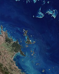
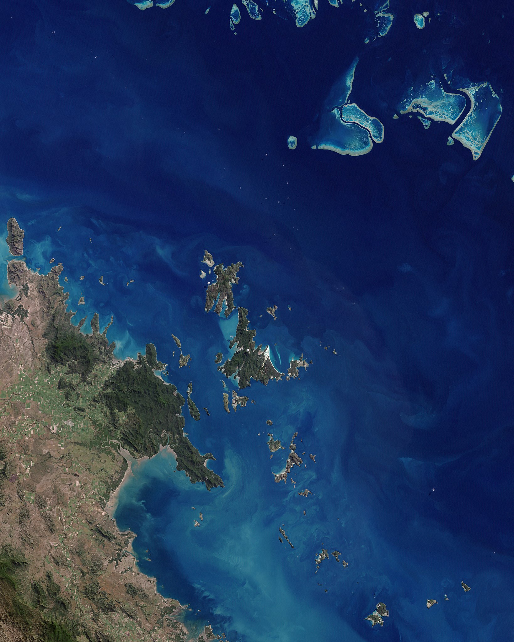
English: This scene is dominated by the largest island and namesake of the chain. Deep green forest covers most of Whitsunday Island, which is outlined by brilliant white sand beaches, the largest and most dramatic being Whitehaven Beach at the south-eastern end of the island. On Hamilton Island, the strong linear feature at the southern end shows where a jet-accessible runway was added to allow airlines from major Australian cities to fly directly to the islands. The swirls of pale blue around the islands show a mix of sandy bottom waters and shallow, fringing coral reefs. The green land in the south-western corner of the image is a small section of Conway Ranges National Park, on the shoreline of mainland Queensland.
Deutsch: Dieses photoähnliche Bild des Kerns der Whitsunday Islands wurde am 22. Mai 2003 mit dem Enhanced Thematic Mapper Plus (ETM+) des Landsat 7 erstellt. Das Bild wird von der größten Insel und Namensgeberin für die gesamte Inselgruppe dominiert. Den größtem Teil der Whitsunday Island bedecken tiefgrüne Wälder, die von brillanten weißen Sandstränden eingerahmt werden – der größte unter ihnen ist Whitehaven Beach im Südosten der Insel. |
| Datum | |
| Bron | NASA Earth Observatory |
| Auteur | Jesse Allen |
| Andere versies | File:Whitsunday Islands Landsat 7 with some captions.jpg |
Image acquired by the Enhanced Thematic Mapper Plus (ETM+) instrument on NASA’s Landsat 7 satellite. Landsat data provided by the United States Geological Survey.
Licentie
| Dit bestand bevindt zich in het publiek domein, omdat het gemaakt is door de NASA. In de reproductierichtlijnen van de NASA staat dat "NASA-materiaal niet beschermd wordt door auteursrecht, tenzij anders vermeld". | ||
 |
Waarschuwingen:
|
| Aantekeningen | Deze afbeelding is aangetekend: Bekijk de aantekeningen op Commons |
Bestandsgeschiedenis
Klik op een datum/tijd om het bestand te zien zoals het destijds was.
| Datum/tijd | Miniatuur | Afmetingen | Gebruiker | Opmerking | |
|---|---|---|---|---|---|
| huidige versie | 7 jan 2010 14:26 | | 4.000 × 5.000 (3,43 MB) | Originalwana | {{Information |Description={{en|1=This scene is dominated by the largest island and namesake of the chain. Deep green forest covers most of Whitsunday Island, which is outlined by brilliant white sand beaches, the largest and most dramatic being Whitehave |
Bestandsgebruik
Dit bestand wordt op de volgende pagina gebruikt:
Globaal bestandsgebruik
De volgende andere wiki's gebruiken dit bestand:
- Gebruikt op af.wikipedia.org
- Gebruikt op be.wikipedia.org
- Gebruikt op en.wikipedia.org
- Gebruikt op eo.wikipedia.org
- Gebruikt op it.wikipedia.org
- Gebruikt op mr.wikipedia.org
- Gebruikt op pl.wikipedia.org
- Gebruikt op ru.wikipedia.org
- Gebruikt op zh.wikipedia.org