Bestand:Venezuela Division Politica Territorial.svg

Afmetingen van deze voorvertoning van het type PNG van dit SVG-bestand: 781 × 600 pixels Andere resoluties: 313 × 240 pixels | 625 × 480 pixels | 1.000 × 768 pixels | 1.280 × 983 pixels | 2.560 × 1.966 pixels | 2.121 × 1.629 pixels.
Oorspronkelijk bestand (SVG-bestand, nominaal 2.121 × 1.629 pixels, bestandsgrootte: 141 kB)
| Dit is een bestand van Wikimedia Commons. Onderstaande beschrijving komt van de beschrijving van het bestand daar. |
| Beschrijving |
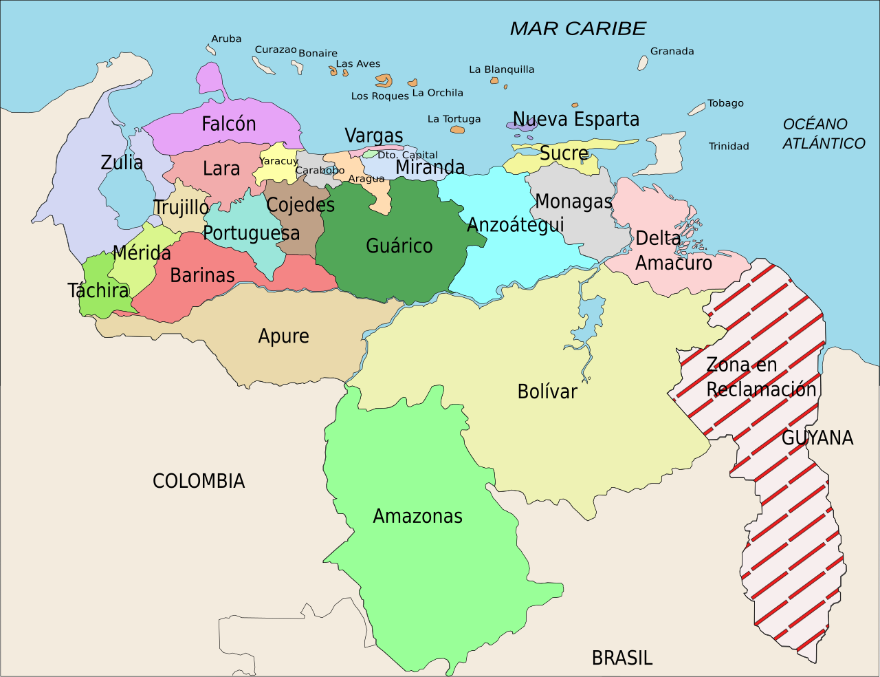
Español: División Político Territorial de Venezuela. Es un mapa acerca de los estados de Venezuela o división político territorial. La zona en reclamación aun no se sabe si pertenece a Guyana o a Venezuela, por eso se suele colocar de esa manera.
English: Political divisions of Venezuela. The Reclamation zone is Guyanan territory claimed by Venezuela. |
| Datum | |
| Bron | self work, Image:Venezuela politica copy.png based |
| Auteur | Wilfredor |
| Toestemming (Hergebruik van dit bestand) |
Own work, copyleft: Multi-license with GFDL and Creative Commons CC-BY-SA-2.5 and older versions (2.0 and 1.0) |
| Andere versies |
Afgeleide werken van dit bestand: Venezuela Division Politica Territorial mk.svg
[]
|


Deze niet W3C-verklaarde vectorafbeelding is gemaakt met Inkscape .
Ik, de auteursrechthebbende van dit werk, maak het hierbij onder de volgende licenties beschikbaar:

|
Toestemming wordt verleend voor het kopiëren, verspreiden en/of wijzigen van dit document onder de voorwaarden van de GNU-licentie voor vrije documentatie, versie 1.2 of enige latere versie als gepubliceerd door de Free Software Foundation; zonder Invariant Sections, zonder Front-Cover Texts, en zonder Back-Cover Texts. Een kopie van de licentie is opgenomen in de sectie GNU-licentie voor vrije documentatie. |
| Dit bestand is gelicenseerd onder de Creative Commons-licentie Naamsvermelding-Gelijk delen 3.0 Unported | ||
| ||
| Deze licentietag is toegevoegd aan dit bestand in verband met de GFDL licentie-update. |
Dit bestand is gelicenseerd onder de Creative Commons-licenties Naamsvermelding-Gelijk delen 2.5 Algemeen, 2.0 Algemeen en 1.0 Algemeen.
- De gebruiker mag:
- Delen – het werk kopiëren, verspreiden en doorgeven
- Remixen – afgeleide werken maken
- Onder de volgende voorwaarden:
- naamsvermelding – U moet op een gepaste manier aan naamsvermelding doen, een link naar de licentie geven, en aangeven of er wijzigingen in het werk zijn aangebracht. U mag dit op elke redelijke manier doen, maar niet zodanig dat de indruk wordt gewekt dat de licentiegever instemt met uw werk of uw gebruik van zijn werk.
- Gelijk delen – Als u het werk heeft geremixt, veranderd, of erop heeft voortgebouwd, moet u het gewijzigde materiaal verspreiden onder dezelfde licentie als het oorspronkelijke werk, of een daarmee compatibele licentie.
U mag zelf één van de licenties kiezen.
Bestandsgeschiedenis
Klik op een datum/tijd om het bestand te zien zoals het destijds was.
| Datum/tijd | Miniatuur | Afmetingen | Gebruiker | Opmerking | |
|---|---|---|---|---|---|
| huidige versie | 16 apr 2008 23:00 | | 2.121 × 1.629 (141 kB) | Wilfredor | {{Information |Description= '''(Spanish):''' División Político Territorial de Venezuela. Es un mapa acerca de los estados de Venezuela o división político territorial. La zona en reclamación aun no se sabe si pertenece a Guyana o a Venezuela, por es |
| 21 apr 2007 17:17 |  | 2.121 × 1.629 (140 kB) | Wilfredor | {{Information |Description= '''(Spanish):''' División Político Territorial de Venezuela. Es un mapa acerca de los estados de Venezuela o división político territorial. La zona en reclamación aun no se sabe si pertenece a Guyana o a Venezuela, por es | |
| 19 apr 2007 23:11 |  | 2.121 × 1.629 (135 kB) | Spundun | Reverted to earlier revision | |
| 19 apr 2007 23:10 |  | 2.119 × 1.629 (135 kB) | Spundun | Reverted to earlier revision | |
| 19 apr 2007 16:52 |  | 2.121 × 1.629 (135 kB) | Wilfredor | {{Information |Description= '''(Spanish):''' División Político Territorial de Venezuela </br> '''(English):''' Politic Territorial Division of Venezuela |Source=self work, Image:Venezuela politica copy.png based |Date=2007 |Author=[[user:wilfredo | |
| 18 apr 2007 02:33 |  | 2.119 × 1.629 (135 kB) | Wilfredor | {{Information |Description= '''(Spanish):''' División Político Territorial de Venezuela </br> '''(English):''' Politic Territorial Division of Venezuela |Source=self work |Date=2007 |Author=Wilfredo R. Rodriguez H. |Permission=Own wo | |
| 18 apr 2007 01:55 |  | 2.119 × 1.629 (124 kB) | Wilfredor | {{Information |Description= '''(Spanish):''' División Político Territorial de Venezuela </br> '''(English):''' Politic Territorial Division of Venezuela |Source=self work |Date=2007 |Author=Wilfredo R. Rodriguez H. |Permission=Own wo | |
| 17 apr 2007 22:56 |  | 2.160 × 1.664 (107 kB) | Wilfredor | {{Information |Description= '''(Spanish):''' División Político Territorial de Venezuela </br> '''(English):''' Politic Territorial Division of Venezuela |Source=self work |Date=2007 |Author=Wilfredo R. Rodriguez H. |Permission=Own wo | |
| 17 apr 2007 15:30 |  | 2.160 × 1.664 (88 kB) | Wilfredor | {{Information |Description= '''(Spanish):''' División Político Territorial de Venezuela </br> '''(English):''' Politic Territorial Division of Venezuela |Source=self work |Date=2007 |Author=Wilfredo R. Rodriguez H. |Permission=Own wo | |
| 17 apr 2007 04:54 |  | 2.160 × 1.664 (83 kB) | Wilfredor | {{Information |Description= '''(Spanish):''' División Político Territorial de Venezuela </br> '''(English):''' Politic Territorial Division of Venezuela |Source=self work |Date=2007 |Author=Wilfredo R. Rodriguez H. |Permission=Own wo |
Bestandsgebruik
Dit bestand wordt op de volgende pagina gebruikt:
Globaal bestandsgebruik
De volgende andere wiki's gebruiken dit bestand:
- Gebruikt op an.wikipedia.org
- Gebruikt op be.wikipedia.org
- Gebruikt op br.wikipedia.org
- Gebruikt op bs.wikipedia.org
- Gebruikt op cs.wikipedia.org
- Gebruikt op da.wikipedia.org
- Gebruikt op de.wikipedia.org
- Gebruikt op en.wikipedia.org
- Gebruikt op es.wikipedia.org
- Categoría:Estados de Venezuela
- Wikiproyecto Discusión:Venezuela/1
- Categoría:Municipios de Venezuela
- Usuario:Dezulovic
- Anexo:Gobernadores de Venezuela
- Agua potable y saneamiento en Venezuela
- Categoría:Geografía de Venezuela por estado
- Categoría:Localidades de Venezuela por estado
- Wikiproyecto:Relaciones bilaterales/creados
- Gebruikt op es.wikibooks.org
- Gebruikt op es.wikinews.org
- Gebruikt op fiu-vro.wikipedia.org
- Gebruikt op fi.wikipedia.org
- Gebruikt op frr.wikipedia.org
- Gebruikt op fr.wikipedia.org
- Projet:Géographie/Palettes de navigation
- Modèle:Palette États du Venezuela
- États du Venezuela
- État de Bolívar
- État de La Guaira
- État de Táchira
- État de Lara
- État de Falcón
- État d'Yaracuy
- État de Carabobo
- État de Zulia
- État de Portuguesa
- État de Trujillo
- État de Cojedes
- État d'Aragua
- État d'Amazonas (Venezuela)
- État de Guárico
- État de Barinas
Globaal gebruik van dit bestand bekijken.