Bestand:Urbanized population 2006.png

Grootte van deze voorvertoning: 800 × 364 pixels. Andere resoluties: 320 × 146 pixels | 640 × 292 pixels | 1.024 × 466 pixels | 1.280 × 583 pixels | 3.600 × 1.640 pixels.
Oorspronkelijk bestand (3.600 × 1.640 pixels, bestandsgrootte: 550 kB, MIME-type: image/png)
| Dit is een bestand van Wikimedia Commons. Onderstaande beschrijving komt van de beschrijving van het bestand daar. |
Beschrijving
| Beschrijving |
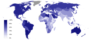
English: Urbanized population percentage by country as of 2006. Source: UNICEF, The State of the World’s Children 2008 (p. 134)
Deze kaart is gemaakt met GunnMap GunnMap was created by Arthur Gunn and is available, free, at http://gunn.co.nz/map/ and http://gunnmap.herokuapp.com/. Please attribute by linking to http://gunn.co.nz/map/. |
| Datum | |
| Bron | Based on BlankMap-World6, compact.svg by Canuckguy et al. |
| Auteur | Jelle564 |
Licentie
| Ik, de auteursrechthebbende van dit werk, geef dit werk vrij in het publieke domein. Dit is wereldwijd van toepassing. In sommige landen is dit wettelijk niet mogelijk; in die gevallen geldt: Ik sta iedereen toe dit werk voor eender welk doel te gebruiken, zonder enige voorwaarden, tenzij zulke voorwaarden door de wet worden voorgeschreven. |
Bestandsgeschiedenis
Klik op een datum/tijd om het bestand te zien zoals het destijds was.
| Datum/tijd | Miniatuur | Afmetingen | Gebruiker | Opmerking | |
|---|---|---|---|---|---|
| huidige versie | 19 feb 2017 15:41 | | 3.600 × 1.640 (550 kB) | Zywang114072 | Change and update country urbanized population degree color: Taiwan |
| 16 jan 2009 18:48 |  | 3.600 × 1.640 (362 kB) | Jelle564 | {{Information |Description={{en|1=Urbanized population percentage by country as of 2006. Source: http://www.unicef.org/sowc08/docs/sowc08_table_StatisticalTables.pdf {{GunnMap}}}} |Source=Based on [[:Image:BlankMap-World6, compact.svg|BlankMap-World6, com |
Bestandsgebruik
Dit bestand wordt op de volgende pagina gebruikt:
Globaal bestandsgebruik
De volgende andere wiki's gebruiken dit bestand:
- Gebruikt op ar.wikipedia.org
- Gebruikt op bg.wikipedia.org
- Gebruikt op ca.wikipedia.org
- Gebruikt op es.wikipedia.org
- Gebruikt op fa.wikipedia.org
- Gebruikt op gu.wikipedia.org
- Gebruikt op it.wikipedia.org
- Gebruikt op ka.wikipedia.org
- Gebruikt op la.wikipedia.org
- Gebruikt op lt.wikipedia.org
- Gebruikt op nn.wikipedia.org
- Gebruikt op no.wikipedia.org
- Gebruikt op pl.wikipedia.org
- Gebruikt op pt.wikipedia.org
- Gebruikt op ta.wikipedia.org
- Gebruikt op ur.wikipedia.org