Bestand:US insular areas FAS.png

Oorspronkelijk bestand (1.482 × 624 pixels, bestandsgrootte: 32 kB, MIME-type: image/png)
| Dit is een bestand van Wikimedia Commons. Onderstaande beschrijving komt van de beschrijving van het bestand daar. |
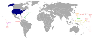
Beschrijving
This is a map of the US Insular areas with the freely associated states of the Marshall Islands, Palau, and the Federated States of Micronesia (according to the US Office of Insular Affairs archief kopie op de Wayback Machine, these islands are insular areas). The base map is Image:Dependent_territories_2007.png by User:Sesmith. This map is color coded according to each islands' status. Here is the key:
For an uncolor-coded map, see Image:US_insular_areas-B FAS.png. For a version without the freely associated states, see Image:US_insular_areas.png.
The previous map is PD; because of this, this map is too.
Licentie
| Ik, de auteursrechthebbende van dit werk, geef dit werk vrij in het publieke domein. Dit is wereldwijd van toepassing. In sommige landen is dit wettelijk niet mogelijk; in die gevallen geldt: Ik sta iedereen toe dit werk voor eender welk doel te gebruiken, zonder enige voorwaarden, tenzij zulke voorwaarden door de wet worden voorgeschreven. |
Bestandsgeschiedenis
Klik op een datum/tijd om het bestand te zien zoals het destijds was.
| Datum/tijd | Miniatuur | Afmetingen | Gebruiker | Opmerking | |
|---|---|---|---|---|---|
| huidige versie | 5 mrt 2008 07:00 | | 1.482 × 624 (32 kB) | Hoshie | == Summary == This is a map of the US Insular areas with the freely associated states of the Marshall Islands, Palau, and the Federated States of Micronesia (according to the [http://www.doi.gov/oia/Islandpages/political_types.htm US Office of Insular Af |
Bestandsgebruik
Dit bestand wordt op de volgende pagina gebruikt:
Globaal bestandsgebruik
De volgende andere wiki's gebruiken dit bestand:
- Gebruikt op ckb.wikipedia.org
- Gebruikt op en.wikipedia.org
- Gebruikt op fa.wikipedia.org
- Gebruikt op id.wikipedia.org
- Gebruikt op mzn.wikipedia.org
- Gebruikt op ru.wikipedia.org
- Gebruikt op tg.wikipedia.org
- Gebruikt op zh.wikipedia.org