Bestand:US Roman Catholic dioceses map.png

Oorspronkelijk bestand (1.513 × 983 pixels, bestandsgrootte: 109 kB, MIME-type: image/png)
| Dit is een bestand van Wikimedia Commons. Onderstaande beschrijving komt van de beschrijving van het bestand daar. |

|
Bestand:US Roman Catholic dioceses map.svg is een vectorversie van dit bestand. Indien niet van slechtere kwaliteit dient deze gebruikt te worden in plaats van deze rasterafbeelding.
File:US Roman Catholic dioceses map.png → File:US Roman Catholic dioceses map.svg
Zie Help:SVG voor meer informatie. |
 |
Beschrijving
| Beschrijving |
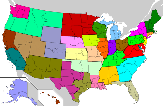
Français : Les trente-deux provinces ecclésiastiques de rite latin aux États-Unis. English: Geographical Latin rite Roman Catholic ecclesiastical provinces of the United States. Each of the 33 ecclesiastical provinces is a separate color. Eastern rite eparchies and dioceses are not shown. |
| Datum | |
| Bron | based on en:Image:Dioceses.GIF by John Kenney |
| Auteur | Closeapple |
| Toestemming (Hergebruik van dit bestand) |
GDFL, same as original |
| Andere versies | en:Image:Dioceses.GIF (older image but with same current data) |
Based on en:Image:Dioceses.GIF by John Kenney, which was based on U.S. county maps already on Wikipedia. Changes by Closeapple using The Gimp: made water bodies transparent; removed dithering on Canada and Mexico; gave each of the 33 provinces a unique color; colored Isle Royale in Michigan, islands in northwestern Washington state, and minor islands in Alaska, California, Florida, North Carolina, and Texas; removed some spurs left over from erased county lines.
Image characteristics: PNG format, 8-bit palette, 34 unique colors + 1 transparent entry (1 for each province; grey for Canada/Mexico; transparent for water). Recompressed with PNGOUT with 12288-byte blocks.
Licentie
Modifications released by Closeapple under the same GDFL terms as the original work by John Kenney. John Kenney source: "created myself, based on map of US counties already on wikipedia".

|
Toestemming wordt verleend voor het kopiëren, verspreiden en/of wijzigen van dit document onder de voorwaarden van de GNU-licentie voor vrije documentatie, versie 1.2 of enige latere versie als gepubliceerd door de Free Software Foundation; zonder Invariant Sections, zonder Front-Cover Texts, en zonder Back-Cover Texts. Een kopie van de licentie is opgenomen in de sectie GNU-licentie voor vrije documentatie. |
| Dit bestand is gelicenseerd onder de Creative Commons-licentie Naamsvermelding-Gelijk delen 3.0 Unported | ||
| ||
| Deze licentietag is toegevoegd aan dit bestand in verband met de GFDL licentie-update. |
Bestandsgeschiedenis
Klik op een datum/tijd om het bestand te zien zoals het destijds was.
| Datum/tijd | Miniatuur | Afmetingen | Gebruiker | Opmerking | |
|---|---|---|---|---|---|
| huidige versie | 7 jun 2023 11:37 | | 1.513 × 983 (109 kB) | Roberto221 | Combined Nevada and Utah since Las Vegas is now an archdiocese |
| 17 jul 2012 23:23 |  | 1.513 × 983 (63 kB) | Presidentman | fix Texas | |
| 6 jul 2012 19:42 |  | 1.513 × 983 (63 kB) | Presidentman | fixed MI | |
| 6 jul 2012 19:39 |  | 1.513 × 983 (63 kB) | Presidentman | fixed KS & LA | |
| 6 jul 2012 00:11 |  | 1.513 × 983 (63 kB) | Presidentman | Reverted to version as of 20:38, 5 July 2012 | |
| 5 jul 2012 22:40 |  | 1.513 × 983 (63 kB) | Presidentman | Reverted to version as of 20:38, 5 July 2012 | |
| 5 jul 2012 22:39 |  | 1.513 × 983 (63 kB) | Presidentman | correcting colors | |
| 5 jul 2012 22:38 |  | 1.513 × 983 (63 kB) | Presidentman | Changed KY, LA, & TN colors | |
| 5 jul 2012 21:37 |  | 1.513 × 983 (60 kB) | Presidentman | switched Alaska & Nebraska colors | |
| 22 apr 2006 08:19 |  | 1.513 × 983 (29 kB) | Closeapple | {{Information| |Description=Geographical Latin rite w:Roman Catholic dioceses of the United States. Each of the 32 ecclesiastical provinces is a separate color. Eastern rite eparchies and dioceses are not shown. |Source=based on [[:en:Image: |
Bestandsgebruik
Dit bestand wordt op de volgende pagina gebruikt:
Globaal bestandsgebruik
De volgende andere wiki's gebruiken dit bestand:
- Gebruikt op cs.wikipedia.org
- Gebruikt op de.wikipedia.org
- Gebruikt op en.wikipedia.org
- Catholic Church in the United States
- List of Catholic bishops in the United States
- List of Catholic dioceses (structured view)
- User:Eagle4000/List of the Catholic ecclesiastical provinces of the United States
- Wikipedia:Graphics Lab/Map workshop/Archive/Jul 2012
- Wikipedia:Graphics Lab/Map workshop/Archive/Dec 2012
- User talk:Planemad/Archive 6
- Gebruikt op es.wikipedia.org
- Gebruikt op fr.wikipedia.org
- Gebruikt op it.wikipedia.org
- Gebruikt op ko.wikipedia.org
- Gebruikt op la.wikipedia.org
- Gebruikt op no.wikipedia.org
- Gebruikt op pl.wikipedia.org
- Podział administracyjny Kościoła katolickiego w Stanach Zjednoczonych
- Archidiecezja Anchorage-Juneau
- Archidiecezja Seattle
- Archidiecezja waszyngtońska
- Archidiecezja Indianapolis
- Archidiecezja Baltimore
- Archidiecezja San Antonio
- Archidiecezja Miami
- Archidiecezja San Francisco
- Archidiecezja Chicago
- Archidiecezja Bostonu
- Kościół katolicki w Stanach Zjednoczonych
- Kategoria:Diecezje rzymskokatolickie w Stanach Zjednoczonych
- Archidiecezja Hartford
- Rozwój administracji Kościoła katolickiego w Stanach Zjednoczonych
- Archidiecezja Los Angeles
- Metropolia Anchorage-Juneau
- Metropolia Atlanty
- Archidiecezja Atlanty
- Szablon:Metropolie rzymskokatolickie w Stanach Zjednoczonych
- Archidiecezja Denver
- Archidiecezja Detroit
- Archidiecezja Filadelfii
- Archidiecezja Galveston-Houston
- Archidiecezja Milwaukee
- Archidiecezja Newark
- Archidiecezja St. Louis
Globaal gebruik van dit bestand bekijken.