Bestand:Tambora volcano.jpg
Geen hogere resolutie beschikbaar.
Tambora_volcano.jpg (640 × 436 pixels, bestandsgrootte: 67 kB, MIME-type: image/jpeg)
| Dit is een bestand van Wikimedia Commons. Onderstaande beschrijving komt van de beschrijving van het bestand daar. |
Beschrijving
| Beschrijving |
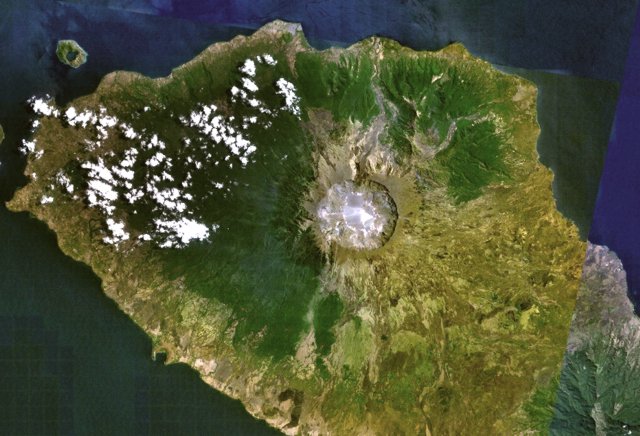
English: Tambora volcano on Indonesia's Sumbawa Island was the site of the world's largest historical eruption in April 1815. This NASA Landsat mosaic shows the 6-km-wide caldera truncating the 2850-m-high summit of the massive volcano. Pyroclastic flows during the 1815 eruption reached the sea on all sides of the 60-km-wide volcanic peninsula, and the ejection of large amounts of tephra caused world-wide temperature declines in 1815 and 1816. |
| Datum | Datum onbekend |
| Bron | http://www.volcano.si.edu/world/volcano.cfm?vnum=0604-04=&volpage=photos&photo=115009 |
| Auteur | NASA Landsat7 image (worldwind.arc.nasa.gov) |
Licentie
| Deze afbeelding bevindt zich in het publiek domein omdat het een screenshot is van NASA’s software World Wind die gebruik maakt van een publiek domein-laag, zoals Blue Marble, MODIS, Landsat, SRTM, USGS of GLOBE.
|
 |
Bestandsgeschiedenis
Klik op een datum/tijd om het bestand te zien zoals het destijds was.
| Datum/tijd | Miniatuur | Afmetingen | Gebruiker | Opmerking | |
|---|---|---|---|---|---|
| huidige versie | 30 jul 2010 00:29 | | 640 × 436 (67 kB) | Michael Metzger | {{Information |Description={{en|1=Tambora volcano on Indonesia's Sumbawa Island was the site of the world's largest historical eruption in April 1815. This NASA Landsat mosaic shows the 6-km-wide caldera truncating the 2850-m-high summit of the massive vo |
Bestandsgebruik
Dit bestand wordt op de volgende pagina gebruikt:
Globaal bestandsgebruik
De volgende andere wiki's gebruiken dit bestand:
- Gebruikt op de.wikipedia.org
- Gebruikt op en.wikiversity.org
- Gebruikt op fr.wikipedia.org
- Gebruikt op ja.wikipedia.org
- Gebruikt op ka.wikipedia.org
- Gebruikt op oc.wikipedia.org