Bestand:Sud Italia nel 1112.jpg
Grootte van deze voorvertoning: 529 × 600 pixels. Andere resoluties: 212 × 240 pixels | 423 × 480 pixels | 712 × 807 pixels.
Oorspronkelijk bestand (712 × 807 pixels, bestandsgrootte: 94 kB, MIME-type: image/jpeg)
| Dit is een bestand van Wikimedia Commons. Onderstaande beschrijving komt van de beschrijving van het bestand daar. |
Beschrijving
| Beschrijving |
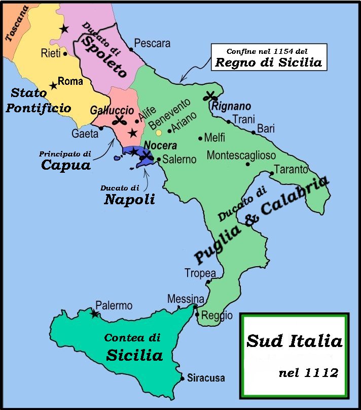
English: This is a political map of southern Italy in 1112 AD/CE, the date when Roger II of Sicily reached his age of majority, also showing the border of the Kingdom of Sicily in 1154, on his death.
"The rarity of surviving records makes it impossible to draw a map of comital [counts'] responsibiities in southern Italy at the beginning of the twelth century." Matthew, p. 23. As noted by Matthew, the political situation in southern Italy is much more complex than this map shows. There were numerous counts and semi-independent cities throughout the region. Moreover, the near-constant rebellions and conquests continually re-arranged the map. |
| Datum | |
| Bron | File:Southern Italy 1112.svg MapMaster |
| Auteur | MapMaster |
| Andere versies |
[]
|


References
- Bjorklund, Oddvar; Holmboe, Haakon; Rohr, Anders (1970) Historical Atlas of the World, Barnes & Noble, NY, SBN: 389-00253-4.
- Houben, Hubert (translated by Graham A. Loud and Diane Milburn), (2002) Roger II of Sicily: Ruler between East and West, Cambridge University Press.
- Konstam, Angus (2000) Atlas of Medieval Europe, Checkmark Books, New York.
- Matthew, Donald (1992) The Norman Kingdom of Sicily Cambridge Medieval Textbooks.
Licentie
Ik, de auteursrechthebbende van dit werk, maak het hierbij onder de volgende licenties beschikbaar:

|
Toestemming wordt verleend voor het kopiëren, verspreiden en/of wijzigen van dit document onder de voorwaarden van de GNU-licentie voor vrije documentatie, versie 1.2 of enige latere versie als gepubliceerd door de Free Software Foundation; zonder Invariant Sections, zonder Front-Cover Texts, en zonder Back-Cover Texts. Een kopie van de licentie is opgenomen in de sectie GNU-licentie voor vrije documentatie. |
This file is licensed under the Creative Commons Attribution-Share Alike Attribution-Share Alike 4.0 International, 3.0 Unported, 2.5 Generic, 2.0 Generic and 1.0 Generic license.
- De gebruiker mag:
- Delen – het werk kopiëren, verspreiden en doorgeven
- Remixen – afgeleide werken maken
- Onder de volgende voorwaarden:
- naamsvermelding – U moet op een gepaste manier aan naamsvermelding doen, een link naar de licentie geven, en aangeven of er wijzigingen in het werk zijn aangebracht. U mag dit op elke redelijke manier doen, maar niet zodanig dat de indruk wordt gewekt dat de licentiegever instemt met uw werk of uw gebruik van zijn werk.
- Gelijk delen – Als u het werk heeft geremixt, veranderd, of erop heeft voortgebouwd, moet u het gewijzigde materiaal verspreiden onder dezelfde licentie als het oorspronkelijke werk, of een daarmee compatibele licentie.
U mag zelf één van de licenties kiezen.
Bestandsgeschiedenis
Klik op een datum/tijd om het bestand te zien zoals het destijds was.
| Datum/tijd | Miniatuur | Afmetingen | Gebruiker | Opmerking | |
|---|---|---|---|---|---|
| huidige versie | 1 mrt 2008 20:59 | | 712 × 807 (94 kB) | Franco aq | {{Information |Description= |Source=Wikimedia Commons |Date=01 03 2008 |Author=User:MapMaster |other_versions=Image:Southern Italy 1112.svg }} |
Bestandsgebruik
Dit bestand wordt op de volgende pagina gebruikt:
Globaal bestandsgebruik
De volgende andere wiki's gebruiken dit bestand:
- Gebruikt op arz.wikipedia.org
- Gebruikt op bg.wikipedia.org
- Gebruikt op br.wikipedia.org
- Gebruikt op ca.wikipedia.org
- Gebruikt op co.wikipedia.org
- Gebruikt op de.wikipedia.org
- Gebruikt op el.wikipedia.org
- Gebruikt op fr.wikipedia.org
- Gebruikt op gl.wikipedia.org
- Gebruikt op hu.wikipedia.org
- Gebruikt op it.wikipedia.org
- Napoli
- Rainulfo di Alife
- Sovrani dei regni di Sicilia e di Napoli
- Antichi Stati italiani
- Montescaglioso
- Ducato di Napoli
- Regno di Sicilia
- Terra di Lavoro
- Storia di Napoli
- Principato di Capua
- Roberto II di Capua
- Battaglia di Nocera
- Alfonso d'Altavilla
- Suddivisione amministrativa del Regno di Napoli
- Contea di Sicilia
- Ducato di Puglia e Calabria
- Storia della Campania
- Cortimpiano
- Resti e reperti archeologici della metropolitana di Napoli
- Utente:Memnone di Rodi/Sandbox/Napoli
- Contea di Tricarico
- Sovrani italiani
- Giordano II di Capua
- Cronologia della storia di Teramo
- Gebruikt op lt.wikipedia.org
- Gebruikt op pl.wikipedia.org
- Gebruikt op uk.wikipedia.org
- Gebruikt op vi.wikipedia.org