Bestand:SpaghettiJunctionGA.jpg

Grootte van deze voorvertoning: 800 × 527 pixels. Andere resoluties: 320 × 211 pixels | 640 × 421 pixels | 992 × 653 pixels.
Oorspronkelijk bestand (992 × 653 pixels, bestandsgrootte: 129 kB, MIME-type: image/jpeg)
| Dit is een bestand van Wikimedia Commons. Onderstaande beschrijving komt van de beschrijving van het bestand daar. |
| Cameralocatie | | Deze en andere afbeeldingen in: OpenStreetMap |
|---|
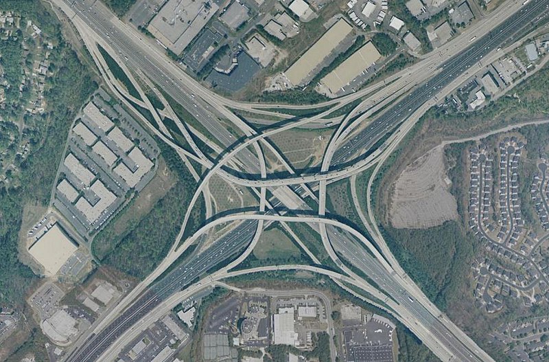
Tom Moreland Interchange, a.k.a. Spaghetti Junction, intersection of Interstate 85 and Interstate 285, just northeast of Atlanta, Georgia, USA. Latitude 33.89221, Longitude -84.25964. Aerial view from USGS "Urban Areas" image database. Composed using NASA World Wind.
Deze afbeelding bevindt zich in het publiek domein omdat het materiaal bevat dat oorspronkelijk afkomstig is van de United States Geological Survey, een agentschap van de United States Department of the Interior. Voor meer informatie, zie het officiële USGS-auteursrechtenbeleid
|
Bestandsgeschiedenis
Klik op een datum/tijd om het bestand te zien zoals het destijds was.
| Datum/tijd | Miniatuur | Afmetingen | Gebruiker | Opmerking | |
|---|---|---|---|---|---|
| huidige versie | 20 mrt 2005 11:16 | | 992 × 653 (129 kB) | Ray Spalding | Spaghetti Junction, GA {{PD-USGov-Interior-USGS}} |
Bestandsgebruik
Dit bestand wordt op de volgende 2 pagina's gebruikt:
Globaal bestandsgebruik
De volgende andere wiki's gebruiken dit bestand:
- Gebruikt op br.wikipedia.org
- Gebruikt op de.wikipedia.org
- Gebruikt op en.wikipedia.org
- Gebruikt op hu.wikipedia.org
- Gebruikt op sk.wikipedia.org
- Gebruikt op sl.wikipedia.org
- Gebruikt op tr.wikipedia.org
- Gebruikt op zh.wikipedia.org