Bestand:South Africa 2001 Afrikaans speakers proportion map.svg

Afmetingen van deze voorvertoning van het type PNG van dit SVG-bestand: 689 × 600 pixels Andere resoluties: 276 × 240 pixels | 552 × 480 pixels | 882 × 768 pixels | 1.177 × 1.024 pixels | 2.353 × 2.048 pixels | 1.072 × 933 pixels.
Oorspronkelijk bestand (SVG-bestand, nominaal 1.072 × 933 pixels, bestandsgrootte: 479 kB)
| Dit is een bestand van Wikimedia Commons. Onderstaande beschrijving komt van de beschrijving van het bestand daar. |
Beschrijving
| Beschrijving |
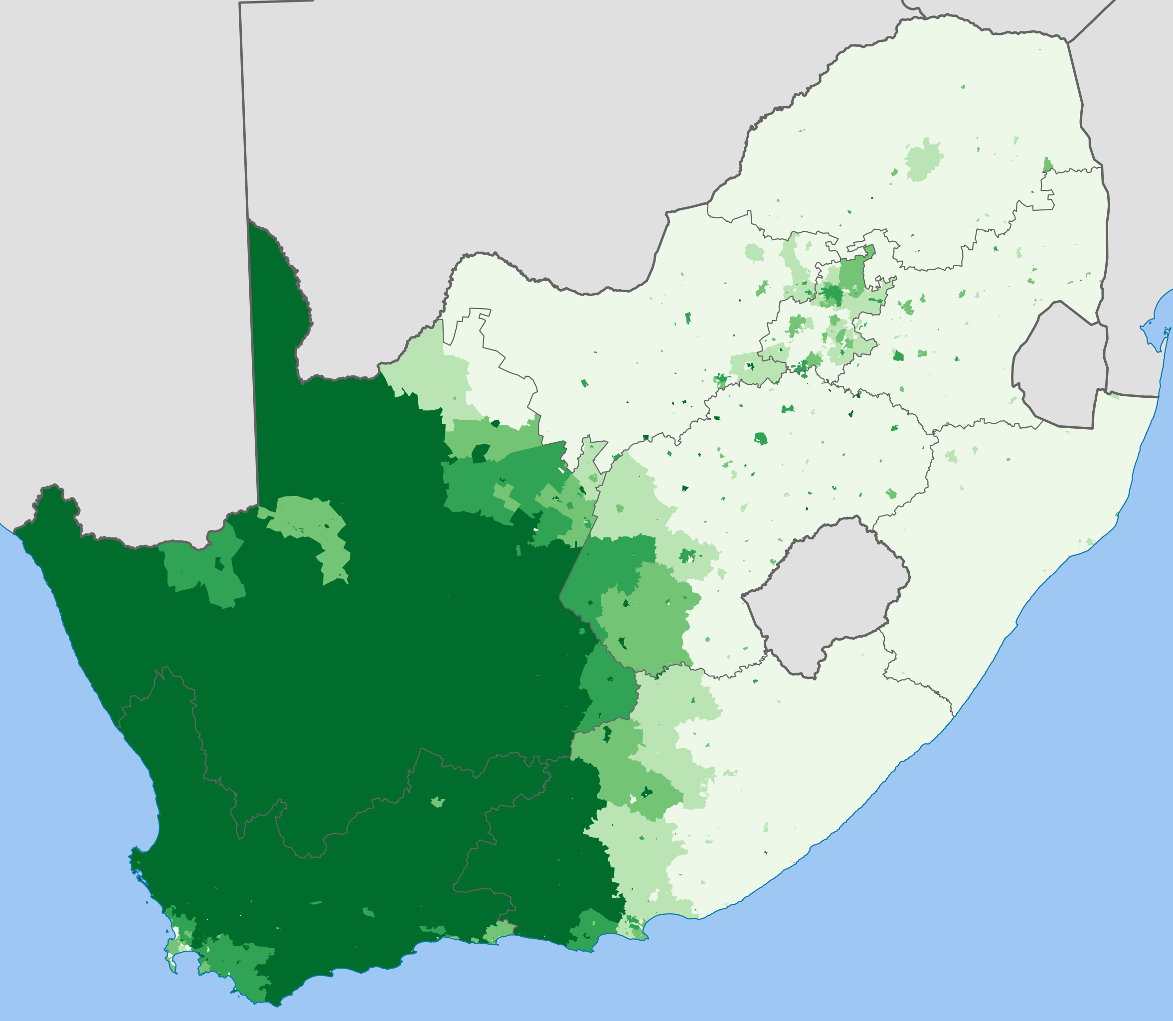
English: Map showing the proportion of the South African population that speaks Afrikaans at home, from the 2001 census broken down to "Main Place" level.
0–20%
20–40%
40–60%
60–80%
80–100%
Projection is Albers Equal-Area Conic, with standard parallels at 25.5° S and 31.5° S, and origin at 28.5° S 25.5° E. |
| Datum | |
| Bron | Statistics South Africa's Census 2001 is the source of the basic population data. The map results from my own processing of the data. |
| Auteur | Htonl |
Licentie
The following license applies to the population data on which the map is based:

|
De auteursrechthebbende van dit bestand, Stats SA, staat iedereen toe het voor willekeurig welk doel te gebruiken, mits de auteursrechthebbende correct met naam wordt genoemd.
Heruitgave, afgeleide werken, commercieel gebruik en alle andere vormen van gebruik zijn toegestaan. |
Naamsvermelding:
"the user acknowledges Stats SA as the source of the basic data wherever they process, apply, utilise, publish or distribute the data, and also that they specify that the relevant application and analysis (where applicable) result from their own processing of the data" [1]
|
The following tag applies to the map itself:
| Ik, de auteursrechthebbende van dit werk, geef dit werk vrij in het publieke domein. Dit is wereldwijd van toepassing. In sommige landen is dit wettelijk niet mogelijk; in die gevallen geldt: Ik sta iedereen toe dit werk voor eender welk doel te gebruiken, zonder enige voorwaarden, tenzij zulke voorwaarden door de wet worden voorgeschreven. |
Bestandsgeschiedenis
Klik op een datum/tijd om het bestand te zien zoals het destijds was.
| Datum/tijd | Miniatuur | Afmetingen | Gebruiker | Opmerking | |
|---|---|---|---|---|---|
| huidige versie | 3 apr 2012 20:17 | | 1.072 × 933 (479 kB) | Htonl | styles, color handling, color scheme |
| 29 nov 2010 12:46 |  | 1.072 × 933 (902 kB) | Htonl | remove grey "undefined" areas by drawing from municipal data | |
| 2 okt 2010 03:46 |  | 1.072 × 933 (925 kB) | Htonl | tweak | |
| 2 okt 2010 03:17 |  | 1.072 × 933 (838 kB) | Htonl | new approach, smaller filesize | |
| 1 okt 2010 22:17 |  | 1.072 × 933 (2,92 MB) | Htonl | use equal-area projection | |
| 16 feb 2010 21:15 |  | 1.000 × 786 (2,81 MB) | Htonl | tweak | |
| 6 feb 2010 22:56 |  | 1.000 × 786 (3,04 MB) | Htonl | == Summary == {{Information |Description={{en|1=Map showing the proportion of the South African population that speaks Afrikaans at home, from the 2001 census broken down to "Main Place" level. {{legend|#eff3ff|0–20%}} {{legend|#bdd7e7|20–40%}} {{lege |
Bestandsgebruik
Dit bestand wordt op de volgende pagina gebruikt:
Globaal bestandsgebruik
De volgende andere wiki's gebruiken dit bestand:
- Gebruikt op eo.wiktionary.org
- Gebruikt op it.wikipedia.org
- Gebruikt op nrm.wikipedia.org
- Gebruikt op pl.wikipedia.org