Bestand:Sorex palustris distribution.svg

Afmetingen van deze voorvertoning van het type PNG van dit SVG-bestand: 515 × 599 pixels Andere resoluties: 206 × 240 pixels | 412 × 480 pixels | 660 × 768 pixels | 880 × 1.024 pixels | 1.760 × 2.048 pixels | 1.712 × 1.992 pixels.
Oorspronkelijk bestand (SVG-bestand, nominaal 1.712 × 1.992 pixels, bestandsgrootte: 240 kB)
| Dit is een bestand van Wikimedia Commons. Onderstaande beschrijving komt van de beschrijving van het bestand daar. |
| Beschrijving |
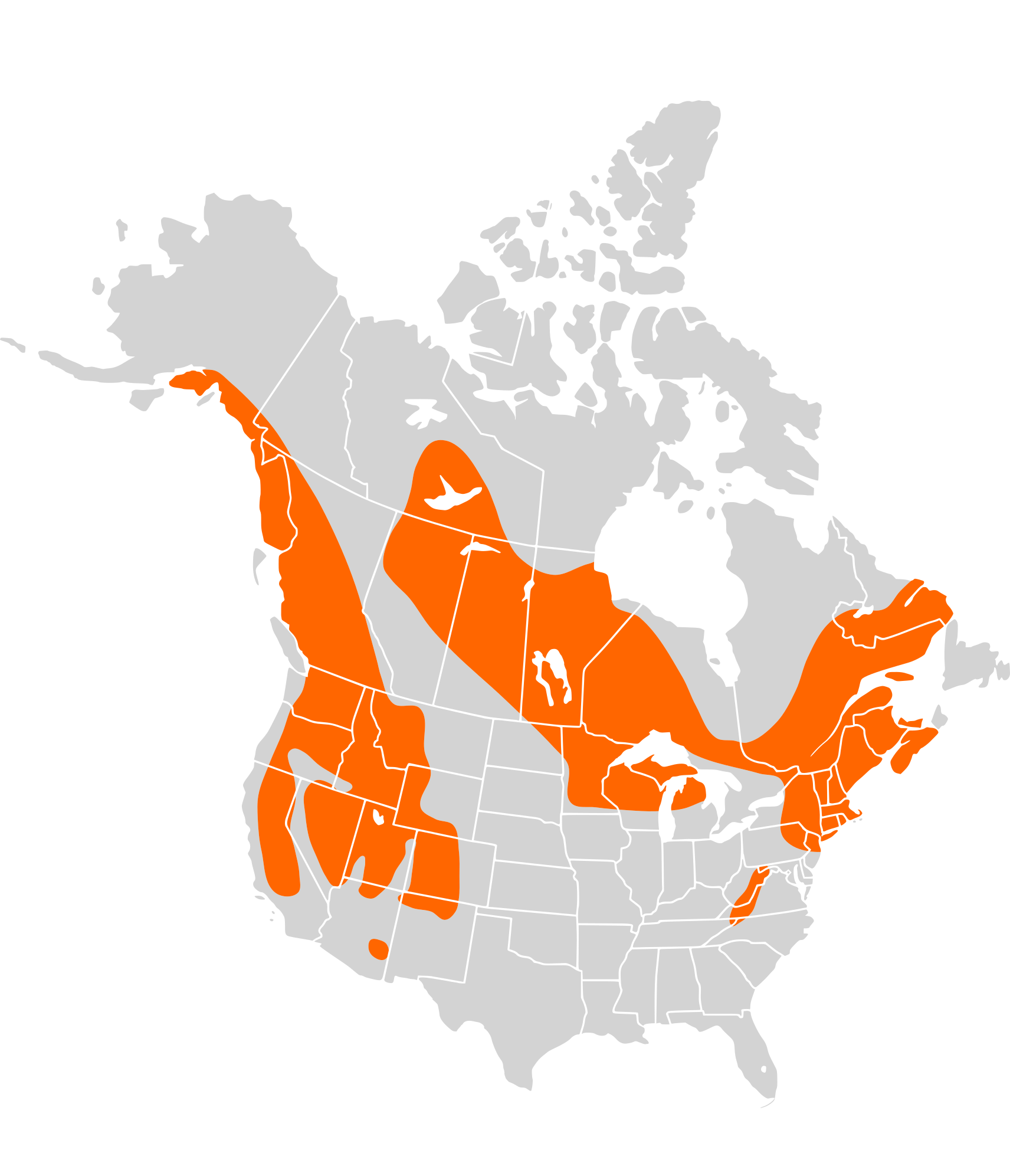
English: Distribution of the American Water Shrew (Sorex palustris) with http://www.mnh.si.edu/mna/thumbnails/maps/322.gif
Français : Distribution de la Musaraigne palustre (Sorex palustris) à partir de http://www.mnh.si.edu/mna/thumbnails/maps/322.gif
De broncode van dit SVG-bestand is deugdelijk. W3C-validity not checked. |
| Datum | (UTC) |
| Bron | |
| Auteur |
|
| Dit is een geretoucheerde foto, wat betekent dat de originele versie digitaal aangepast is. Het origineel kan hier bekeken worden: North America second level political division 2.svg. Aanpassingen gedaan door Totodu74.
|
Ik, de auteursrechthebbende van dit werk, maak het hierbij onder de volgende licentie beschikbaar:
Dit bestand is gelicenseerd onder de Creative Commons-licentie Naamsvermelding-Gelijk delen 2.5 Unported
- De gebruiker mag:
- Delen – het werk kopiëren, verspreiden en doorgeven
- Remixen – afgeleide werken maken
- Onder de volgende voorwaarden:
- naamsvermelding – U moet op een gepaste manier aan naamsvermelding doen, een link naar de licentie geven, en aangeven of er wijzigingen in het werk zijn aangebracht. U mag dit op elke redelijke manier doen, maar niet zodanig dat de indruk wordt gewekt dat de licentiegever instemt met uw werk of uw gebruik van zijn werk.
- Gelijk delen – Als u het werk heeft geremixt, veranderd, of erop heeft voortgebouwd, moet u het gewijzigde materiaal verspreiden onder dezelfde licentie als het oorspronkelijke werk, of een daarmee compatibele licentie.
Oorspronkelijk uploadlogboek
This image is a derivative work of the following images:
- File:North_America_second_level_political_division_2.svg licensed with Cc-by-sa-2.5
- 2007-12-08T23:23:36Z Lokal Profil 1712x1992 (335351 Bytes) Code cleanup
- 2007-10-07T07:55:13Z AlexCovarrubias 1712x1992 (350437 Bytes) == Summary == {{Information |Description=Map of North America and its second-level political divisions. Canadian provinces, US and Mexican states. Canada, Mexico, United States. |Source=Canada and US map by Alan Rockefeller.
Uploaded with derivativeFX
Bestandsgeschiedenis
Klik op een datum/tijd om het bestand te zien zoals het destijds was.
| Datum/tijd | Miniatuur | Afmetingen | Gebruiker | Opmerking | |
|---|---|---|---|---|---|
| huidige versie | 31 jan 2010 19:08 | | 1.712 × 1.992 (240 kB) | Totodu74 | {{Information |Description={{en|Map of North America and its second-level political divisions. Canadian provinces, US and Mexican states. Canada, Mexico, United States. Non-contiguous parts of a states/provinces are "grouped" together with the main area |
Bestandsgebruik
Dit bestand wordt op de volgende pagina gebruikt:
Globaal bestandsgebruik
De volgende andere wiki's gebruiken dit bestand:
- Gebruikt op ar.wikipedia.org
- Gebruikt op avk.wikipedia.org
- Gebruikt op ceb.wikipedia.org
- Gebruikt op de.wikipedia.org
- Gebruikt op en.wikipedia.org
- Gebruikt op fr.wikipedia.org
- Gebruikt op he.wikipedia.org
- Gebruikt op is.wikipedia.org
- Gebruikt op nv.wikipedia.org
- Gebruikt op pt.wikipedia.org
- Gebruikt op ru.wikipedia.org
- Gebruikt op simple.wikipedia.org
- Gebruikt op sv.wikipedia.org
- Gebruikt op uk.wikipedia.org
- Gebruikt op vi.wikipedia.org