Bestand:Snake River watershed map.png

Grootte van deze voorvertoning: 649 × 600 pixels. Andere resoluties: 260 × 240 pixels | 520 × 480 pixels | 831 × 768 pixels | 1.211 × 1.119 pixels.
Oorspronkelijk bestand (1.211 × 1.119 pixels, bestandsgrootte: 2,1 MB, MIME-type: image/png)
| Dit is een bestand van Wikimedia Commons. Onderstaande beschrijving komt van de beschrijving van het bestand daar. |
Beschrijving
| Beschrijving |
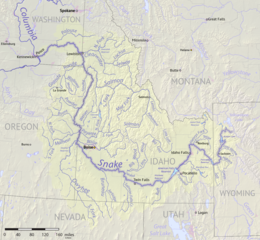
English: Map of the Snake River watershed, USA. Intended to replace older File:SnakeRiverNicerMap.jpg. Created using public domain USGS National Map data. |
| Datum | |
| Bron | Eigen werk |
| Auteur | Shannon1 |
Licentie
Ik, de auteursrechthebbende van dit werk, maak het hierbij onder de volgende licenties beschikbaar:

|
Toestemming wordt verleend voor het kopiëren, verspreiden en/of wijzigen van dit document onder de voorwaarden van de GNU-licentie voor vrije documentatie, versie 1.2 of enige latere versie als gepubliceerd door de Free Software Foundation; zonder Invariant Sections, zonder Front-Cover Texts, en zonder Back-Cover Texts. Een kopie van de licentie is opgenomen in de sectie GNU-licentie voor vrije documentatie. |
This file is licensed under the Creative Commons Attribution-Share Alike 4.0 International, 3.0 Unported, 2.5 Generic, 2.0 Generic and 1.0 Generic license.
- De gebruiker mag:
- Delen – het werk kopiëren, verspreiden en doorgeven
- Remixen – afgeleide werken maken
- Onder de volgende voorwaarden:
- naamsvermelding – U moet op een gepaste manier aan naamsvermelding doen, een link naar de licentie geven, en aangeven of er wijzigingen in het werk zijn aangebracht. U mag dit op elke redelijke manier doen, maar niet zodanig dat de indruk wordt gewekt dat de licentiegever instemt met uw werk of uw gebruik van zijn werk.
- Gelijk delen – Als u het werk heeft geremixt, veranderd, of erop heeft voortgebouwd, moet u het gewijzigde materiaal verspreiden onder dezelfde licentie als het oorspronkelijke werk, of een daarmee compatibele licentie.
U mag zelf één van de licenties kiezen.
Bestandsgeschiedenis
Klik op een datum/tijd om het bestand te zien zoals het destijds was.
| Datum/tijd | Miniatuur | Afmetingen | Gebruiker | Opmerking | |
|---|---|---|---|---|---|
| huidige versie | 9 sep 2017 04:45 | | 1.211 × 1.119 (2,1 MB) | Shannon1 | {{Information |Description ={{en|1=Map of the Snake River watershed, USA. Intended to replace older File:SnakeRiverNicerMap.jpg. Created using public domain USGS National Map data.}} |Source =Own work |Author =[[User:Shannon1|Sh... |
Bestandsgebruik
Dit bestand wordt op de volgende pagina gebruikt:
Globaal bestandsgebruik
De volgende andere wiki's gebruiken dit bestand:
- Gebruikt op af.wikipedia.org
- Gebruikt op azb.wikipedia.org
- Gebruikt op be.wikipedia.org
- Gebruikt op bg.wikipedia.org
- Gebruikt op ca.wikipedia.org
- Gebruikt op ceb.wikipedia.org
- Gebruikt op cs.wikipedia.org
- Gebruikt op de.wikipedia.org
- Gebruikt op el.wikipedia.org
- Gebruikt op en.wikipedia.org
- Gebruikt op es.wikipedia.org
- Idaho
- Oregón
- Washington (estado)
- Boise
- Río Snake
- Pocatello (Idaho)
- Río Raft
- Río Portneuf
- Río Clearwater (Idaho)
- Río Boise
- Río Owyhee
- Baker City
- Ontario (Oregón)
- Vale (Oregón)
- Owyhee (Nevada)
- American Falls (Idaho)
- Ammon (Idaho)
- Blackfoot (Idaho)
- Jackson (Wyoming)
- Buhl (Idaho)
- Burley (Idaho)
- Emmett (Idaho)
- Homedale (Idaho)
- Idaho Falls
- McCall (Idaho)
- Meridian (Idaho)
- Mountain Home (Idaho)
- Nampa (Idaho)
Globaal gebruik van dit bestand bekijken.