Bestand:ScotlandDumfriesGalloway.png
Geen hogere resolutie beschikbaar.
ScotlandDumfriesGalloway.png (200 × 230 pixels, bestandsgrootte: 4 kB, MIME-type: image/png)
| Dit is een bestand van Wikimedia Commons. Onderstaande beschrijving komt van de beschrijving van het bestand daar. |
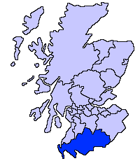
Dumfries and Galloway unitary council
Slightly edited version of a map drawn by Morwen

|
Toestemming wordt verleend voor het kopiëren, verspreiden en/of wijzigen van dit document onder de voorwaarden van de GNU-licentie voor vrije documentatie, versie 1.2 of enige latere versie als gepubliceerd door de Free Software Foundation; zonder Invariant Sections, zonder Front-Cover Texts, en zonder Back-Cover Texts. Een kopie van de licentie is opgenomen in de sectie GNU-licentie voor vrije documentatie. |
| Dit bestand is gelicenseerd onder de Creative Commons-licentie Naamsvermelding-Gelijk delen 3.0 Unported | ||
| ||
| Deze licentietag is toegevoegd aan dit bestand in verband met de GFDL licentie-update. |
Bestandsgeschiedenis
Klik op een datum/tijd om het bestand te zien zoals het destijds was.
| Datum/tijd | Miniatuur | Afmetingen | Gebruiker | Opmerking | |
|---|---|---|---|---|---|
| huidige versie | 17 mei 2005 23:31 | | 200 × 230 (4 kB) | Voyager | Dumfries and Galloway unitary council Slightly edited version of a map drawn by Morwen {{GFDL}} Category:Maps of Scottish unitary councils |
Bestandsgebruik
Geen enkele pagina gebruikt dit bestand.
Globaal bestandsgebruik
De volgende andere wiki's gebruiken dit bestand:
- Gebruikt op ast.wikipedia.org
- Gebruikt op be.wikipedia.org
- Gebruikt op bg.wikipedia.org
- Gebruikt op ca.wikipedia.org
- Gebruikt op cy.wikipedia.org
- Gebruikt op de.wikipedia.org
- Gebruikt op de.wikivoyage.org
- Gebruikt op en.wikipedia.org
- Gebruikt op eu.wikipedia.org
- Dumfries eta Galloway
- Dumfries
- Lankide:Euskaldunaa
- Stranraer
- Annan
- Txantiloi:Dumfries eta Galloway
- Wikiproiektu:Irlanda, Gales eta Eskoziako udalerriak
- Applegarthtown
- Inch (Dumfries eta Galloway)
- Bladnoch (Wigtownshire)
- Cairnryan
- Glasserton
- Glenluce
- Kirkcolm
- Kirkmaiden
- Leswalt
- Mochrum
- New Luce
- Newton Stewart
- Old Luce
- Penninghame
- Port William (Dumfries eta Galloway)
- Portpatrick
- Sandhead
- Sorbie
- Stoneykirk
- Wigtown
- Whithorn
- Kirkcowan
- Kirkinner
- Anwoth
- Caerlaverock
- Barburgh Mill
- Brow (Dumfries eta Galloway)
Globaal gebruik van dit bestand bekijken.