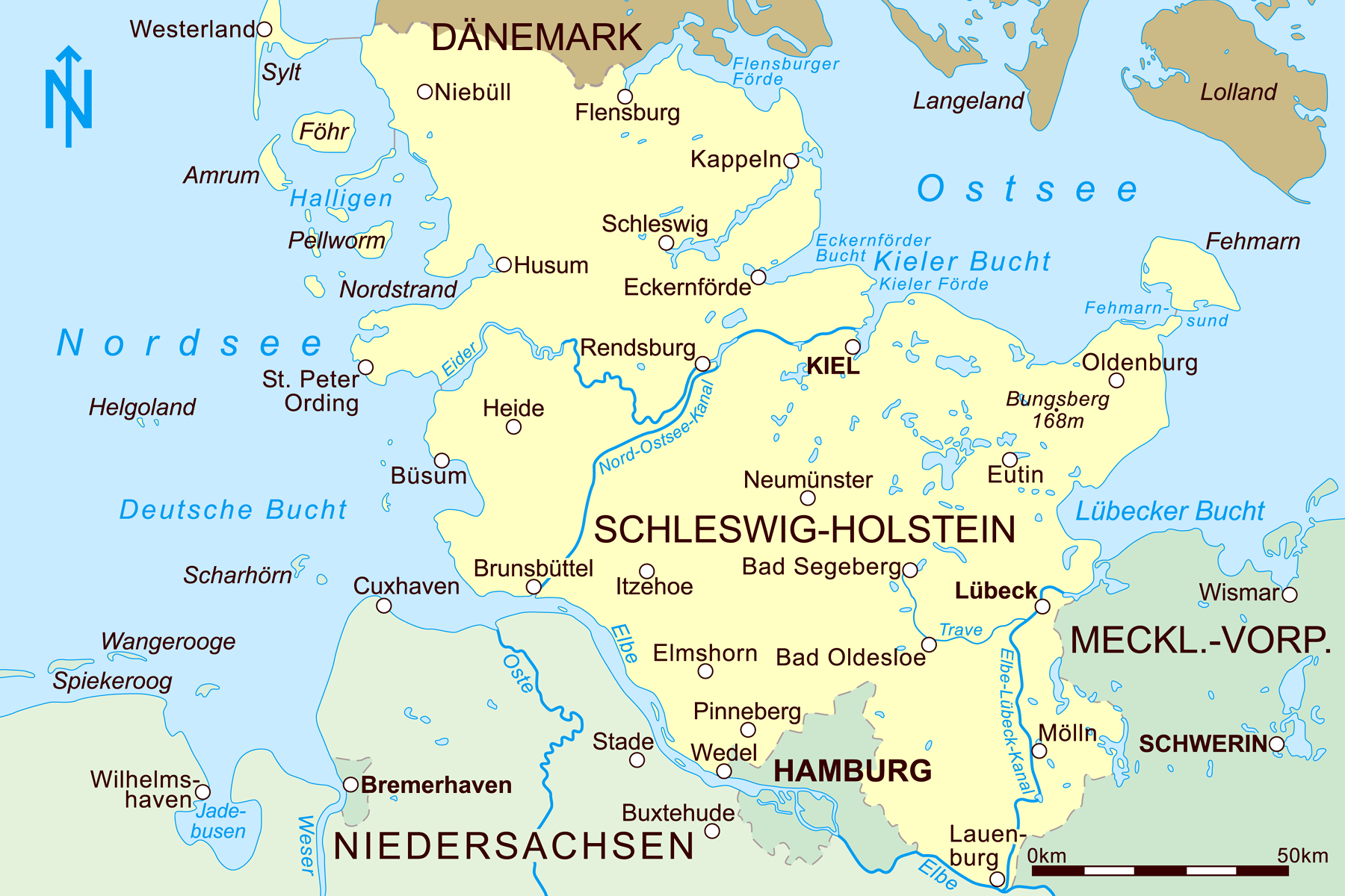
Bestand:Schleswig-Holstein 2010.png
Grootte van deze voorvertoning: 800 × 533 pixels. Andere resoluties: 320 × 213 pixels | 640 × 427 pixels | 1.024 × 683 pixels | 1.280 × 853 pixels | 1.800 × 1.200 pixels.
Oorspronkelijk bestand (1.800 × 1.200 pixels, bestandsgrootte: 670 kB, MIME-type: image/png)
| Dit is een bestand van Wikimedia Commons. Onderstaande beschrijving komt van de beschrijving van het bestand daar. |
Beschrijving
| Beschrijving |
English: Map of Schleswig-Holstein with North Sea-Baltic Sea-Canal
Deutsch: Karte von Schleswig-Holstein mit dem Nord-Ostsee-Kanal |
| Datum | |
| Bron | Eigen werk |
| Auteur | Joe MiGo |
Licentie
Ik, de auteursrechthebbende van dit werk, maak het hierbij onder de volgende licentie beschikbaar:
| Dit bestand is beschikbaar onder Creative Commons CC0 1.0 Universele Public Domain Dedication. | |
| De persoon die een werk voorziet van deze licentie stelt dit werk beschikbaar aan het publieke domein door, voor zover dit wettelijk is toegestaan, afstand te doen van alle rechten op het werk in de zin van het auteursrecht, met inbegrip van alle aanverwante of naburige rechten. U kunt het werk kopiëren, aanpassen, distribueren en uitvoeren, ook voor commerciële doeleinden, zonder dat u daarvoor toestemming hoeft te vragen.
|
Bestandsgeschiedenis
Klik op een datum/tijd om het bestand te zien zoals het destijds was.
| Datum/tijd | Miniatuur | Afmetingen | Gebruiker | Opmerking | |
|---|---|---|---|---|---|
| huidige versie | 1 feb 2021 18:12 | | 1.800 × 1.200 (670 kB) | RokerHRO | optipng -o7 -zm1-9 → 19.33% decrease |
| 13 dec 2010 19:56 |  | 1.800 × 1.200 (831 kB) | Joe MiGo | {{Information |Description={{en|1=Map of Schleswig-Holstein with North Sea-Baltic Sea-Canal}} {{de|1=Karte von Schleswig-Holstein mit Nord-Ostsee-Kanal}} |Source={{own}} |Author=Joe MiGo |Date=2010-12-13 |Permission= |other_versions= }} |
Bestandsgebruik
Dit bestand wordt op de volgende pagina gebruikt:
Globaal bestandsgebruik
De volgende andere wiki's gebruiken dit bestand:
- Gebruikt op da.wikipedia.org
- Gebruikt op de.wikipedia.org
- Gebruikt op es.wikipedia.org
- Gebruikt op no.wikipedia.org
- Gebruikt op pl.wiktionary.org
- Gebruikt op uk.wikipedia.org