Bestand:SanJoaquinRiverMap.jpg

Grootte van deze voorvertoning: 598 × 599 pixels. Andere resoluties: 240 × 240 pixels | 479 × 480 pixels | 767 × 768 pixels | 1.092 × 1.094 pixels.
Oorspronkelijk bestand (1.092 × 1.094 pixels, bestandsgrootte: 1,24 MB, MIME-type: image/jpeg)
| Dit is een bestand van Wikimedia Commons. Onderstaande beschrijving komt van de beschrijving van het bestand daar. |
Beschrijving
| Beschrijving |
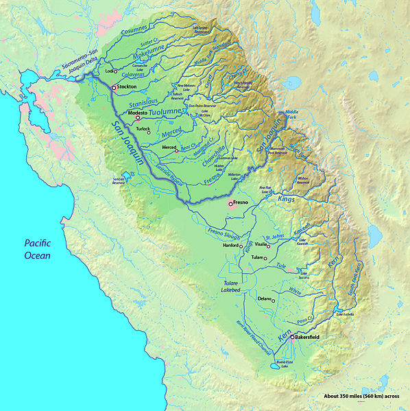
English: Map of the San Joaquin River watershed, which drains most of central inland California into the Pacific |
| Datum | |
| Bron | Background from http://www2.demis.nl/mapserver/mapper.asp |
| Auteur | Background layer attributed to DEMIS Mapserver, map created by Shannon1 |
| Toestemming (Hergebruik van dit bestand) |
Map created from DEMIS Mapserver, which are public domain. |
Licentie
Ik, de auteursrechthebbende van dit werk, maak het hierbij onder de volgende licenties beschikbaar:

|
Toestemming wordt verleend voor het kopiëren, verspreiden en/of wijzigen van dit document onder de voorwaarden van de GNU-licentie voor vrije documentatie, versie 1.2 of enige latere versie als gepubliceerd door de Free Software Foundation; zonder Invariant Sections, zonder Front-Cover Texts, en zonder Back-Cover Texts. Een kopie van de licentie is opgenomen in de sectie GNU-licentie voor vrije documentatie. |
This file is licensed under the Creative Commons Attribution-Share Alike Attribution-Share Alike 4.0 International, 3.0 Unported, 2.5 Generic, 2.0 Generic and 1.0 Generic license.
- De gebruiker mag:
- Delen – het werk kopiëren, verspreiden en doorgeven
- Remixen – afgeleide werken maken
- Onder de volgende voorwaarden:
- naamsvermelding – U moet op een gepaste manier aan naamsvermelding doen, een link naar de licentie geven, en aangeven of er wijzigingen in het werk zijn aangebracht. U mag dit op elke redelijke manier doen, maar niet zodanig dat de indruk wordt gewekt dat de licentiegever instemt met uw werk of uw gebruik van zijn werk.
- Gelijk delen – Als u het werk heeft geremixt, veranderd, of erop heeft voortgebouwd, moet u het gewijzigde materiaal verspreiden onder dezelfde licentie als het oorspronkelijke werk, of een daarmee compatibele licentie.
U mag zelf één van de licenties kiezen.
Bestandsgeschiedenis
Klik op een datum/tijd om het bestand te zien zoals het destijds was.
| Datum/tijd | Miniatuur | Afmetingen | Gebruiker | Opmerking | |
|---|---|---|---|---|---|
| huidige versie | 8 sep 2012 22:14 | | 1.092 × 1.094 (1,24 MB) | Shannon1 | increased resolution and fixed some river courses in tulare basin |
| 31 jan 2011 06:31 |  | 917 × 753 (454 kB) | Shannon1 | updated, fixed some river paths, added location of dry lakes | |
| 30 jan 2010 20:56 |  | 1.205 × 956 (623 kB) | Shannon1 | {{Information |Description={{en|1=Map of the San Joaquin River watershed, which drains most of central inland California into the Pacific}} |Source=Background from http://www2.demis.nl/mapserver/mapper.asp |Author=Background layer attributed to DEMIS Map |
Bestandsgebruik
Geen enkele pagina gebruikt dit bestand.
Globaal bestandsgebruik
De volgende andere wiki's gebruiken dit bestand:
- Gebruikt op en.wikipedia.org
- Gebruikt op es.wikipedia.org
- Gebruikt op hr.wikipedia.org
- Gebruikt op id.wikipedia.org
- Gebruikt op zh.wikipedia.org