Bestand:Saint Martin map.svg

Afmetingen van deze voorvertoning van het type PNG van dit SVG-bestand: 800 × 558 pixels Andere resoluties: 320 × 223 pixels | 640 × 447 pixels | 1.024 × 715 pixels | 1.280 × 894 pixels | 2.560 × 1.787 pixels | 1.060 × 740 pixels.
Oorspronkelijk bestand (SVG-bestand, nominaal 1.060 × 740 pixels, bestandsgrootte: 598 kB)
| Dit is een bestand van Wikimedia Commons. Onderstaande beschrijving komt van de beschrijving van het bestand daar. |
Beschrijving
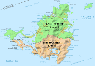
| Beschrijving | Map of of the island of St Martin, with political division | ||
| Datum | |||
| Bron | Saint-Martin Island map-en.svg | ||
| Auteur | Hogweard | ||
| Toestemming (Hergebruik van dit bestand) |
Ik, de auteursrechthebbende van dit werk, maak het hierbij onder de volgende licenties beschikbaar: Dit bestand is gelicenseerd onder de Creative Commons-licentie Naamsvermelding-Gelijk delen 3.0 Unported
U mag zelf één van de licenties kiezen. |

Bestandsgeschiedenis
Klik op een datum/tijd om het bestand te zien zoals het destijds was.
| Datum/tijd | Miniatuur | Afmetingen | Gebruiker | Opmerking | |
|---|---|---|---|---|---|
| huidige versie | 29 apr 2020 12:45 | | 1.060 × 740 (598 kB) | Hogweard | Labels |
| 29 apr 2020 12:35 |  | 1.060 × 740 (595 kB) | Hogweard | {{Information |description=Map of of the island of St Martin, with political division |date=2020-04-29 |source={{f|Saint-Martin Island map-en.svg}} |author={{u|Hogweard}} |permission={{self|cc-by-sa-3.0|GFDL}} |other versions= }} Category:Maps of Saint-Martin |
Bestandsgebruik
Dit bestand wordt op de volgende pagina gebruikt:
Globaal bestandsgebruik
De volgende andere wiki's gebruiken dit bestand:
- Gebruikt op ar.wikipedia.org
- Gebruikt op en.wikipedia.org
- Gebruikt op es.wikipedia.org
- Gebruikt op fa.wikipedia.org
- Gebruikt op he.wikipedia.org
- Gebruikt op incubator.wikimedia.org
- Gebruikt op lv.wikipedia.org
- Gebruikt op pl.wikipedia.org
- Gebruikt op shn.wikipedia.org
- Gebruikt op sr.wikipedia.org
- Gebruikt op www.wikidata.org