Bestand:Sámova říše.png

Grootte van deze voorvertoning: 601 × 600 pixels. Andere resoluties: 241 × 240 pixels | 481 × 480 pixels | 852 × 850 pixels.
Oorspronkelijk bestand (852 × 850 pixels, bestandsgrootte: 184 kB, MIME-type: image/png)
| Dit is een bestand van Wikimedia Commons. Onderstaande beschrijving komt van de beschrijving van het bestand daar. |

|
Deze kaartafbeelding zou opnieuw moeten worden aangemaakt als een SVG-bestand door vectorafbeeldingen te gebruiken. Dit heeft een aantal voordelen; zie Commons:Media for cleanup voor meer informatie. Als er een SVG-formaat van deze afbeelding bestaat, dan deze graag uploaden. Nadat u dit heeft gedaan, gelieve dit sjabloon te vervangen door het sjabloon {{vector version available|nieuwe bestandsnaam.svg}} op deze afbeeldingspagina.
|
| Beschrijving |
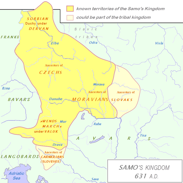
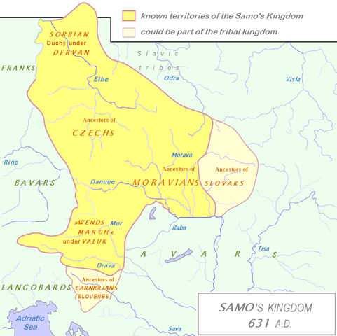
English: Tribal Kingdom of Samo.
Map is based on the maps in:
It is also based on descriptions in:
For eastern and southern extant of tribal kingdom: known territories are shown by the scheme of franco-slavic border and information about the conflicts with Avars is imlemented. The inclusion of Bohemian basin is followed. Contacts with Avars are reached through the territory of Moravians and Eastern Alps. The territories further east and south, which are in proximity of Avars, could be parts of tribal kingdom, too. |
| Datum | (UTC) |
| Bron | |
| Auteur |
|
| Dit is een geretoucheerde foto, wat betekent dat de originele versie digitaal aangepast is. Aanpassingen: The map of Danube basin was used to create map of Kingdom of Samo. Het origineel kan hier bekeken worden: Tribal Kingdom of Samo-sl version.PNG. Aanpassingen gedaan door DancingPhilosopher.
|
Ik, de auteursrechthebbende van dit werk, maak het hierbij onder de volgende licentie beschikbaar:
| Ik, de auteursrechthebbende van dit werk, geef dit werk vrij in het publieke domein. Dit is wereldwijd van toepassing. In sommige landen is dit wettelijk niet mogelijk; in die gevallen geldt: Ik sta iedereen toe dit werk voor eender welk doel te gebruiken, zonder enige voorwaarden, tenzij zulke voorwaarden door de wet worden voorgeschreven. |
Oorspronkelijk uploadlogboek
This image is a derivative work of the following images:
- File:Waterways_of_SE_Central_Europe.svg licensed with PD-self
- 2010-01-08T20:49:27Z Kmiki87 1415x1059 (292577 Bytes) {{Information |Description={{en|1=Waterways along the central and lower Danube, including the Bohemian and Carpathian Basins, the northern Balkans, parts of Austria, southern Poland and Western Ukraine.}} |Source={{own}} |Aut
Bestandsgeschiedenis
Klik op een datum/tijd om het bestand te zien zoals het destijds was.
| Datum/tijd | Miniatuur | Afmetingen | Gebruiker | Opmerking | |
|---|---|---|---|---|---|
| huidige versie | 3 jan 2013 16:27 | | 852 × 850 (184 kB) | DancingPhilosopher | Better map based on http://commons.wikimedia.org/wiki/File:Tribal_Kingdom_of_Samo-sl_version.PNG |
| 28 okt 2010 16:13 |  | 536 × 474 (616 kB) | Aktron | == {{int:filedesc}} == {{OpenStreetMap|name=Sámova říše}} Category:Maps of the history of Austria Category:Maps of the history of Slovakia Category:Maps of the history of Slovenia [[Category:Maps of the history of the Czech Republic |
Bestandsgebruik
Dit bestand wordt op de volgende pagina gebruikt:
Globaal bestandsgebruik
De volgende andere wiki's gebruiken dit bestand:
- Gebruikt op ar.wikipedia.org
- Gebruikt op azb.wikipedia.org
- Gebruikt op az.wikipedia.org
- Gebruikt op be.wikipedia.org
- Gebruikt op bg.wikipedia.org
- Gebruikt op ca.wikipedia.org
- Gebruikt op cs.wikipedia.org
- Gebruikt op de.wikipedia.org
- Gebruikt op de.wikibooks.org
- Gebruikt op en.wikipedia.org
- Gebruikt op et.wikipedia.org
- Gebruikt op fa.wikipedia.org
- Gebruikt op fr.wikipedia.org
- Gebruikt op hy.wikipedia.org
- Gebruikt op id.wikipedia.org
- Gebruikt op it.wikipedia.org
Globaal gebruik van dit bestand bekijken.