Bestand:River Tamar map.png

Grootte van deze voorvertoning: 479 × 600 pixels. Andere resoluties: 192 × 240 pixels | 383 × 480 pixels | 613 × 768 pixels | 818 × 1.024 pixels | 1.503 × 1.882 pixels.
Oorspronkelijk bestand (1.503 × 1.882 pixels, bestandsgrootte: 2,08 MB, MIME-type: image/png)
| Dit is een bestand van Wikimedia Commons. Onderstaande beschrijving komt van de beschrijving van het bestand daar. |
Beschrijving
| Beschrijving |
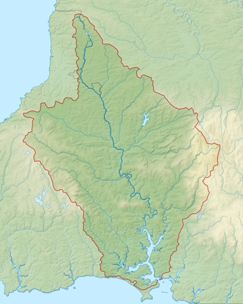
English: Map of the River Tamar and its catchment in Devon and Cornwall, UK. |
| Datum | |
| Bron |
|
| Auteur | Nilfanion, created using Ordnance Survey data |
| Toestemming (Hergebruik van dit bestand) |
Dit bestand is gelicenseerd onder de Creative Commons-licentie Naamsvermelding-Gelijk delen 3.0 Unported Naamsvermelding: Contains Ordnance Survey data © Crown copyright and database right
|
Bestandsgeschiedenis
Klik op een datum/tijd om het bestand te zien zoals het destijds was.
| Datum/tijd | Miniatuur | Afmetingen | Gebruiker | Opmerking | |
|---|---|---|---|---|---|
| huidige versie | 22 feb 2014 00:36 | | 1.503 × 1.882 (2,08 MB) | Nilfanion | == {{int:filedesc}} == {{Information |Description= {{en|Map of the River Tamar and its catchment in Devon and Cornwall, UK.}} |Source=Ordnance Survey [https://www.ordnancesurvey.co.uk/opendatadownload/products.html OpenData]. *Rel... |
Bestandsgebruik
Dit bestand wordt op de volgende pagina gebruikt:
Globaal bestandsgebruik
De volgende andere wiki's gebruiken dit bestand:
- Gebruikt op de.wikipedia.org
- Gebruikt op en.wikipedia.org
- Gebruikt op es.wikipedia.org
- Gebruikt op fa.wikipedia.org
- Gebruikt op fi.wikipedia.org
- Gebruikt op hu.wikipedia.org
- Gebruikt op io.wikipedia.org
- Gebruikt op www.wikidata.org
- Gebruikt op zh.wikipedia.org