Bestand:Provinces of Tuscany map.png
Grootte van deze voorvertoning: 783 × 599 pixels. Andere resoluties: 314 × 240 pixels | 627 × 480 pixels | 989 × 757 pixels.
Oorspronkelijk bestand (989 × 757 pixels, bestandsgrootte: 188 kB, MIME-type: image/png)
| Dit is een bestand van Wikimedia Commons. Onderstaande beschrijving komt van de beschrijving van het bestand daar. |

|
Bestand:Map of region of Tuscany, Italy, with provinces-it.svg is een vectorversie van dit bestand. Indien niet van slechtere kwaliteit dient deze gebruikt te worden in plaats van deze rasterafbeelding.
File:Provinces of Tuscany map.png → File:Map of region of Tuscany, Italy, with provinces-it.svg
Zie Help:SVG voor meer informatie. |
 |
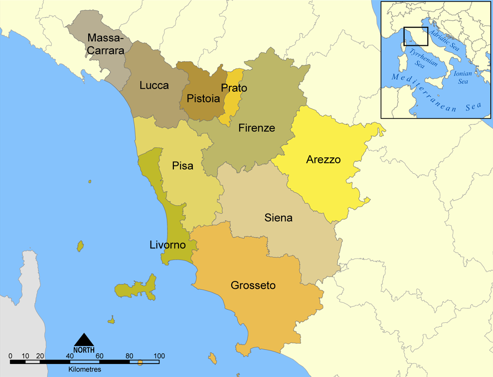
This map shows the provinces of the Italian region of Tuscany.
Created by NormanEinstein, August 26, 2005.
Ik, de auteursrechthebbende van dit werk, maak het hierbij onder de volgende licentie beschikbaar:

|
Toestemming wordt verleend voor het kopiëren, verspreiden en/of wijzigen van dit document onder de voorwaarden van de GNU-licentie voor vrije documentatie, versie 1.2 of enige latere versie als gepubliceerd door de Free Software Foundation; zonder Invariant Sections, zonder Front-Cover Texts, en zonder Back-Cover Texts. Een kopie van de licentie is opgenomen in de sectie GNU-licentie voor vrije documentatie. |
| Dit bestand is gelicenseerd onder de Creative Commons-licentie Naamsvermelding-Gelijk delen 3.0 Unported | ||
| ||
| Deze licentietag is toegevoegd aan dit bestand in verband met de GFDL licentie-update. |
Bestandsgeschiedenis
Klik op een datum/tijd om het bestand te zien zoals het destijds was.
| Datum/tijd | Miniatuur | Afmetingen | Gebruiker | Opmerking | |
|---|---|---|---|---|---|
| huidige versie | 12 jan 2011 16:08 | | 989 × 757 (188 kB) | Ras67 | cropped |
| 8 apr 2006 21:34 |  | 1.000 × 769 (211 kB) | Pitichinaccio | corrected spelling of Pistoia (was Pistoria) | |
| 26 aug 2005 22:57 |  | 1.000 × 769 (276 kB) | NormanEinstein | This map shows the provinces of the Italian region of Tuscany. Created by NormanEinstein, August 26, 2005. {{GFDL-self}} Category: Maps of Italy |
Bestandsgebruik
Geen enkele pagina gebruikt dit bestand.
Globaal bestandsgebruik
De volgende andere wiki's gebruiken dit bestand:
- Gebruikt op an.wikipedia.org
- Gebruikt op ar.wikipedia.org
- Gebruikt op arz.wikipedia.org
- Gebruikt op ast.wikipedia.org
- Gebruikt op br.wikipedia.org
- Gebruikt op ca.wikipedia.org
- Gebruikt op ceb.wikipedia.org
- Gebruikt op cs.wikipedia.org
- Gebruikt op de.wikipedia.org
- Gebruikt op de.wikivoyage.org
- Gebruikt op en.wikipedia.org
- Gebruikt op en.wiktionary.org
- Gebruikt op es.wikipedia.org
- Gebruikt op es.wikiversity.org
Globaal gebruik van dit bestand bekijken.