Bestand:Poitou-Charentes region location map.svg

Afmetingen van deze voorvertoning van het type PNG van dit SVG-bestand: 538 × 599 pixels Andere resoluties: 215 × 240 pixels | 431 × 480 pixels | 690 × 768 pixels | 920 × 1.024 pixels | 1.839 × 2.048 pixels | 1.136 × 1.265 pixels.
Oorspronkelijk bestand (SVG-bestand, nominaal 1.136 × 1.265 pixels, bestandsgrootte: 538 kB)
Dit is een bestand van Wikimedia Commons.
Onderstaande beschrijving komt van de beschrijving van het bestand daar.
Onderstaande beschrijving komt van de beschrijving van het bestand daar.
Beschrijving
| Cameralocatie | | Deze en andere afbeeldingen in: OpenStreetMap |
|---|
| Beschrijving |
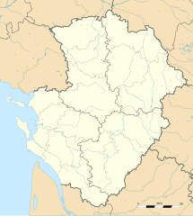
English: Blank administrative map of the region of Poitou-Charentes, France, for geo-location purpose, with distinct boundaries for regions, departments and arrondissements as set in 2008.
Français : Carte administrative vierge de la région Poitou-Charentes, France, destinée à la géolocalisation, avec limite distincte des régions, départements et arrondissements tels que définis en 2008. Approximate scale: 1:800,000 (precision: 200 m)
Geographic limits of the map:
|
||
| Datum | |||
| Bron |
Eigen werk
|
||
| Auteur | Eric Gaba (Sting - fr:Sting) | ||
| Toestemming (Hergebruik van dit bestand) |
|
||
| Andere versies |
|

Licentie
Ik, de auteursrechthebbende van dit werk, maak het hierbij onder de volgende licenties beschikbaar:
Dit bestand is gelicenseerd onder de Creative Commons-licentie Naamsvermelding-Gelijk delen 3.0 Unported
- De gebruiker mag:
- Delen – het werk kopiëren, verspreiden en doorgeven
- Remixen – afgeleide werken maken
- Onder de volgende voorwaarden:
- naamsvermelding – U moet op een gepaste manier aan naamsvermelding doen, een link naar de licentie geven, en aangeven of er wijzigingen in het werk zijn aangebracht. U mag dit op elke redelijke manier doen, maar niet zodanig dat de indruk wordt gewekt dat de licentiegever instemt met uw werk of uw gebruik van zijn werk.
- Gelijk delen – Als u het werk heeft geremixt, veranderd, of erop heeft voortgebouwd, moet u het gewijzigde materiaal verspreiden onder dezelfde licentie als het oorspronkelijke werk, of een daarmee compatibele licentie.

|
Toestemming wordt verleend voor het kopiëren, verspreiden en/of wijzigen van dit document onder de voorwaarden van de GNU-licentie voor vrije documentatie, versie 1.2 of enige latere versie als gepubliceerd door de Free Software Foundation; zonder Invariant Sections, zonder Front-Cover Texts, en zonder Back-Cover Texts. Een kopie van de licentie is opgenomen in de sectie GNU-licentie voor vrije documentatie. |
U mag zelf één van de licenties kiezen.
Bestandsgeschiedenis
Klik op een datum/tijd om het bestand te zien zoals het destijds was.
| Datum/tijd | Miniatuur | Afmetingen | Gebruiker | Opmerking | |
|---|---|---|---|---|---|
| huidige versie | 14 okt 2008 22:32 | | 1.136 × 1.265 (538 kB) | Sting | == Summary == {{Location|46|08|15|N|00|10|30|W|scale:2000000}} <br/> {{Information |Description={{en|Blank administrative map of the region of Poitou-Charentes, France, for geo-location purpose, with distinct boundaries for region |
Bestandsgebruik
Dit bestand wordt op de volgende pagina gebruikt:
Globaal bestandsgebruik
De volgende andere wiki's gebruiken dit bestand:
- Gebruikt op ar.wikipedia.org
- Gebruikt op bg.wikipedia.org
- Gebruikt op ca.wikipedia.org
- Gebruikt op ceb.wikipedia.org
- Gebruikt op cs.wikipedia.org
- Gebruikt op cv.wikipedia.org
- Gebruikt op de.wikipedia.org
- Gebruikt op el.wikipedia.org
- Gebruikt op en.wikipedia.org
- Gebruikt op eo.wikipedia.org
- Gebruikt op es.wikipedia.org
- Gebruikt op fa.wikipedia.org
- Gebruikt op fr.wikipedia.org
- Pictons
- Baptistère Saint-Jean de Poitiers
- Cathédrale Saint-Pierre de Poitiers
- Raids vikings en Poitou et dans la vallée de la Charente
- Modèle:Infobox Port
- Grand Pavois de La Rochelle
- Commanderie d'Ozon
- Abbaye de Saint-Savin-sur-Gartempe
- Église Notre-Dame-de-la-Couldre
- Tumulus de Bougon
- Abbaye Saint-Sauveur de Charroux
- Commanderie Saint-Antoine-de-la-Lande
- Musée Sainte-Croix
- Abbaye de Mauléon
- Pont Neuf (Poitiers)
- Modèle:Géolocalisation/Poitou-Charentes
- Modèle:Carte/Poitou-Charentes
- Wikipédia:Atelier graphique/Cartes/Archives/novembre 2008
- Gare de Lussac-les-Châteaux
- Gare de Mignaloux - Nouaillé
- Projet:Cartographie/Cartes standards/France
Globaal gebruik van dit bestand bekijken.