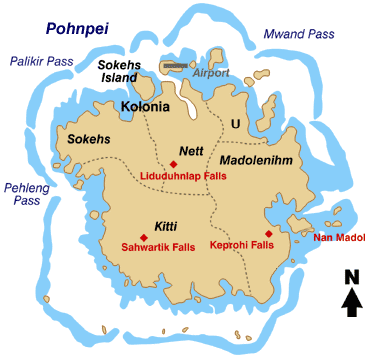
Bestand:Pohnpei map.gif
Pohnpei_map.gif (366 × 356 pixels, bestandsgrootte: 19 kB, MIME-type: image/gif)
Bestandsgeschiedenis
Klik op een datum/tijd om het bestand te zien zoals het destijds was.
| Datum/tijd | Miniatuur | Afmetingen | Gebruiker | Opmerking | |
|---|---|---|---|---|---|
| huidige versie | 7 apr 2008 21:59 |  | 366 × 356 (19 kB) | Scanlan | {{Information |Description=Map of the Island of Pohnpei, in the Federated States of Micronesia |Source=http://www.doi.gov/oia/press/2008/04042008.html |Date=April 4, 2008 |Author= United States government Department of the Interior |Permission= |other |
Bestandsgebruik
Dit bestand wordt op de volgende 7 pagina's gebruikt:
Globaal bestandsgebruik
De volgende andere wiki's gebruiken dit bestand:
- Gebruikt op ar.wikipedia.org
- Gebruikt op bo.wikipedia.org
- Gebruikt op ca.wikipedia.org
- Gebruikt op cs.wikipedia.org
- Gebruikt op de.wikipedia.org
- Gebruikt op en.wikipedia.org
- Gebruikt op eo.wikipedia.org
- Gebruikt op es.wikipedia.org
- Gebruikt op fa.wikipedia.org
- Gebruikt op fr.wikipedia.org
- Gebruikt op gl.wikipedia.org
- Gebruikt op it.wikipedia.org
- Gebruikt op ja.wikipedia.org
- Gebruikt op ka.wikipedia.org
- Gebruikt op ko.wikipedia.org
Globaal gebruik van dit bestand bekijken.

