Bestand:Pearlmap2.png
Grootte van deze voorvertoning: 440 × 599 pixels. Andere resoluties: 176 × 240 pixels | 352 × 480 pixels | 564 × 768 pixels | 752 × 1.024 pixels | 1.292 × 1.760 pixels.
Oorspronkelijk bestand (1.292 × 1.760 pixels, bestandsgrootte: 409 kB, MIME-type: image/png)
| Dit is een bestand van Wikimedia Commons. Onderstaande beschrijving komt van de beschrijving van het bestand daar. |

|
Deze kaartafbeelding zou opnieuw moeten worden aangemaakt als een SVG-bestand door vectorafbeeldingen te gebruiken. Dit heeft een aantal voordelen; zie Commons:Media for cleanup voor meer informatie. Als er een SVG-formaat van deze afbeelding bestaat, dan deze graag uploaden. Nadat u dit heeft gedaan, gelieve dit sjabloon te vervangen door het sjabloon {{vector version available|nieuwe bestandsnaam.svg}} op deze afbeeldingspagina.
|
Beschrijving
| Beschrijving |
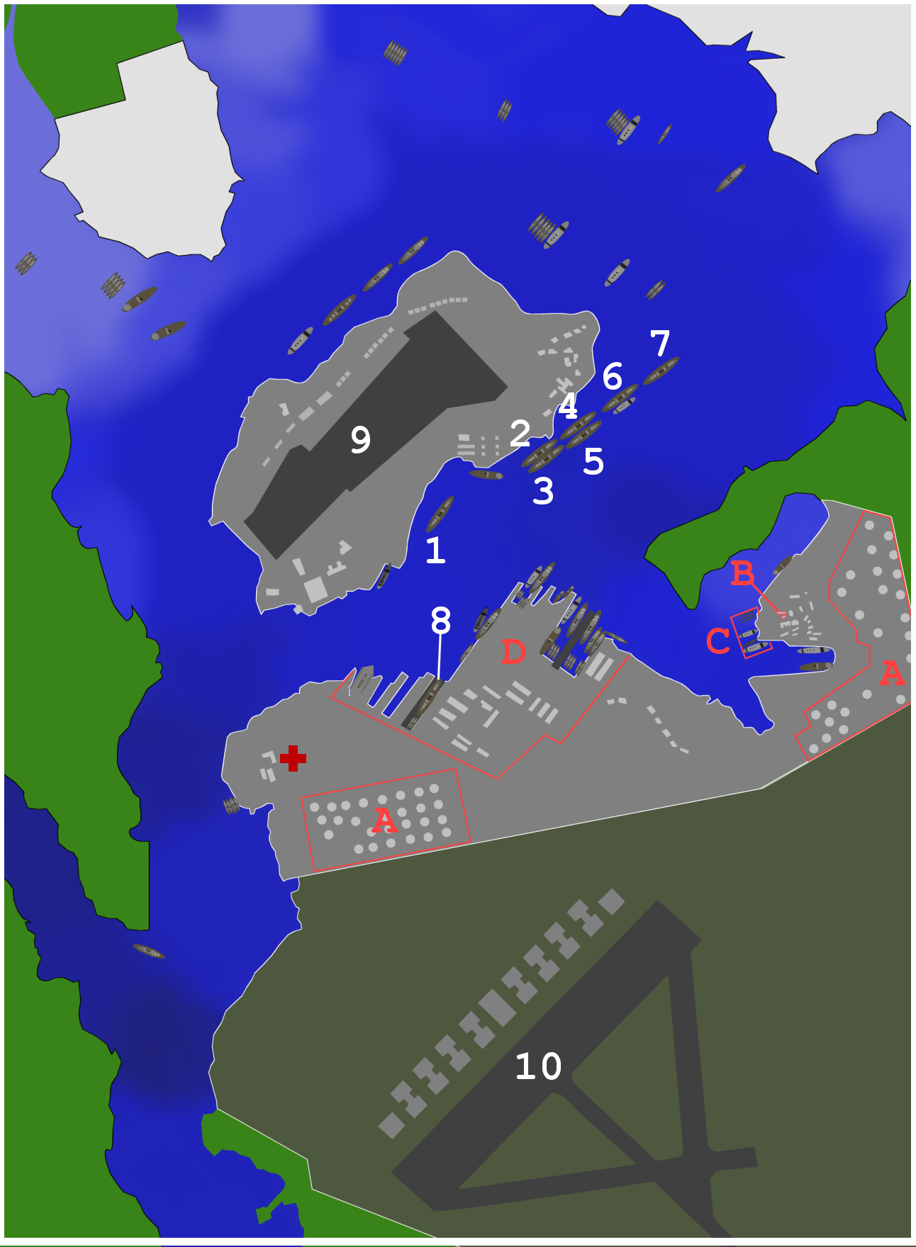
Map of ships and port facilities in Pearl Harbor during the attack. This text based legend is preferred: <21 ft
22-23 ft
29 ft
30-32 ft
33-34 ft
34-35 ft
36-37 ft
38-39 ft
40-41 ft
42-48 ft
>49 ft
City
Army base
Navy base
|
| Datum | (UTC) |
| Bron | Own work using: map from http://www.navsource.org/Naval/ as a reference. |
| Auteur | Anynobody |
| Andere versies |
|


Licentie
Ik, de auteursrechthebbende van dit werk, maak het hierbij onder de volgende licenties beschikbaar:

|
Toestemming wordt verleend voor het kopiëren, verspreiden en/of wijzigen van dit document onder de voorwaarden van de GNU-licentie voor vrije documentatie, versie 1.2 of enige latere versie als gepubliceerd door de Free Software Foundation; zonder Invariant Sections, zonder Front-Cover Texts, en zonder Back-Cover Texts. Een kopie van de licentie is opgenomen in de sectie GNU-licentie voor vrije documentatie. |
Dit bestand is gelicenseerd onder de Creative Commons-licenties Naamsvermelding-Gelijk delen 3.0 Unported, 2.5 Algemeen, 2.0 Algemeen en 1.0 Algemeen.
- De gebruiker mag:
- Delen – het werk kopiëren, verspreiden en doorgeven
- Remixen – afgeleide werken maken
- Onder de volgende voorwaarden:
- naamsvermelding – U moet op een gepaste manier aan naamsvermelding doen, een link naar de licentie geven, en aangeven of er wijzigingen in het werk zijn aangebracht. U mag dit op elke redelijke manier doen, maar niet zodanig dat de indruk wordt gewekt dat de licentiegever instemt met uw werk of uw gebruik van zijn werk.
- Gelijk delen – Als u het werk heeft geremixt, veranderd, of erop heeft voortgebouwd, moet u het gewijzigde materiaal verspreiden onder dezelfde licentie als het oorspronkelijke werk, of een daarmee compatibele licentie.
U mag zelf één van de licenties kiezen.
Bestandsgeschiedenis
Klik op een datum/tijd om het bestand te zien zoals het destijds was.
| Datum/tijd | Miniatuur | Afmetingen | Gebruiker | Opmerking | |
|---|---|---|---|---|---|
| huidige versie | 2 feb 2015 15:40 | | 1.292 × 1.760 (409 kB) | RokerHRO | optipng -o7 -i0 → 12.59% decrease |
| 16 nov 2007 04:39 |  | 1.292 × 1.760 (468 kB) | Anynobody~commonswiki | ||
| 8 nov 2007 01:55 |  | 1.292 × 1.760 (629 kB) | Anynobody~commonswiki | ||
| 26 okt 2007 07:32 |  | 1.292 × 1.760 (675 kB) | Anynobody~commonswiki | w/approx depth, hospital, and seaplane base buildings | |
| 26 okt 2007 05:39 |  | 1.290 × 1.752 (289 kB) | Anynobody~commonswiki | ||
| 26 okt 2007 05:37 |  | 1.292 × 1.760 (289 kB) | Anynobody~commonswiki | {{Information |Description=Map of ships and facilities at Pearl Harbor during the attack. |Source=self-made |Date= ~~~~~ |Author= Anynobody }} Category:Anynobody |
Bestandsgebruik
Dit bestand wordt op de volgende pagina gebruikt:
Globaal bestandsgebruik
De volgende andere wiki's gebruiken dit bestand:
- Gebruikt op ar.wikipedia.org
- Gebruikt op ast.wikipedia.org
- Gebruikt op cs.wikipedia.org
- Gebruikt op de.wikipedia.org
- Gebruikt op en.wikipedia.org
- Gebruikt op es.wikipedia.org
- Gebruikt op fy.wikipedia.org
- Gebruikt op he.wikipedia.org
- Gebruikt op hu.wikipedia.org
- Gebruikt op it.wikipedia.org
- Gebruikt op ja.wikipedia.org
- Gebruikt op pt.wikipedia.org
- Gebruikt op sv.wikipedia.org
- Gebruikt op uk.wikipedia.org
- Gebruikt op vi.wikipedia.org
- Gebruikt op zh.wikipedia.org