Bestand:OxfordshireOxford.png
Geen hogere resolutie beschikbaar.
OxfordshireOxford.png (200 × 267 pixels, bestandsgrootte: 17 kB, MIME-type: image/png)
| Dit is een bestand van Wikimedia Commons. Onderstaande beschrijving komt van de beschrijving van het bestand daar. |
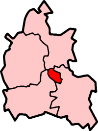
Oxford in Oxfordshire
Created by en:User:Morwen

|
Toestemming wordt verleend voor het kopiëren, verspreiden en/of wijzigen van dit document onder de voorwaarden van de GNU-licentie voor vrije documentatie, versie 1.2 of enige latere versie als gepubliceerd door de Free Software Foundation; zonder Invariant Sections, zonder Front-Cover Texts, en zonder Back-Cover Texts. Een kopie van de licentie is opgenomen in de sectie GNU-licentie voor vrije documentatie. |
| Dit bestand is gelicenseerd onder de Creative Commons-licentie Naamsvermelding-Gelijk delen 3.0 Unported | ||
| ||
| Deze licentietag is toegevoegd aan dit bestand in verband met de GFDL licentie-update. |
Bestandsgeschiedenis
Klik op een datum/tijd om het bestand te zien zoals het destijds was.
| Datum/tijd | Miniatuur | Afmetingen | Gebruiker | Opmerking | |
|---|---|---|---|---|---|
| huidige versie | 27 sep 2005 11:55 | | 200 × 267 (17 kB) | Voyager | City of Oxford shown within Oxfordshire Map by en:User:Morwen Category:Maps of England |
Bestandsgebruik
Dit bestand wordt op de volgende pagina gebruikt:
Globaal bestandsgebruik
De volgende andere wiki's gebruiken dit bestand:
- Gebruikt op azb.wikipedia.org
- Gebruikt op en.wikipedia.org
- Oxford
- Iffley
- Marston, Oxford
- Cowley, Oxfordshire
- Wolvercote
- Oxford East (UK Parliament constituency)
- Oxford West and Abingdon (UK Parliament constituency)
- Littlemore
- Port Meadow, Oxford
- Headington
- Blackbird Leys
- Risinghurst
- Grandpont
- Oxford (UK Parliament constituency)
- Jericho, Oxford
- Risinghurst and Sandhills
- Oxford City Council elections
- North Oxford
- Park Town, Oxford
- New Marston
- Cutteslowe
- Binsey, Oxfordshire
- Godstow
- Headington Rural District
- Osney
- Summertown, Oxford
- St Clement's, Oxford
- Headington Hill
- Rose Hill, Oxfordshire
- New Hinksey
- Hinksey
- Sunnymead
- Barton, Oxfordshire
- Donnington, Oxfordshire
- St. Ebbes
- Oxfordshire (UK Parliament constituency)
- Walton Manor
- Norham Manor
- Oxpens Road
- Template:Oxford
- User:Rst20xx/Contributions and Awards
- St John Street area
- Holywell, Oxford
- Northway, Oxford
- Waterways, Oxford
- Wood Farm, Oxfordshire
Globaal gebruik van dit bestand bekijken.