Bestand:Oceania ISO 3166-1.svg

Afmetingen van deze voorvertoning van het type PNG van dit SVG-bestand: 780 × 500 pixels Andere resoluties: 320 × 205 pixels | 640 × 410 pixels | 1.024 × 656 pixels | 1.280 × 821 pixels | 2.560 × 1.641 pixels.
Oorspronkelijk bestand (SVG-bestand, nominaal 780 × 500 pixels, bestandsgrootte: 146 kB)
| Dit is een bestand van Wikimedia Commons. Onderstaande beschrijving komt van de beschrijving van het bestand daar. |
Beschrijving
| Beschrijving |
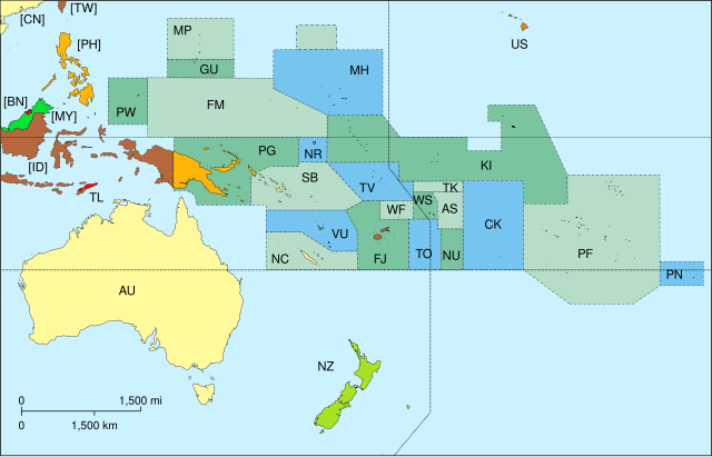
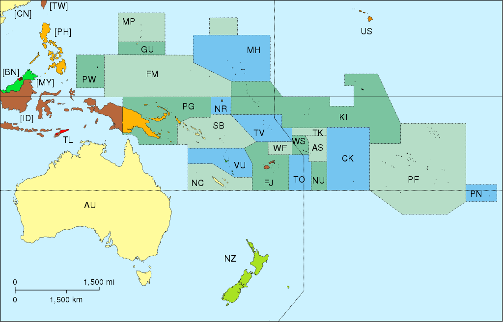
Map of Oceania, with ISO 3166-1 pt · en country and territory code. SVG format. Map legend in Portuguese and English, with name of sovereign state given in parenthesis, where applicable:
On map, but part of Asia:
|
| Datum | |
| Bron | Eigen werk |
| Auteur | Júlio Reis |
| Andere versies |
|


Licentie
Dit bestand is gelicenseerd onder de Creative Commons-licentie Naamsvermelding-Gelijk delen 3.0 Unported
- De gebruiker mag:
- Delen – het werk kopiëren, verspreiden en doorgeven
- Remixen – afgeleide werken maken
- Onder de volgende voorwaarden:
- naamsvermelding – U moet op een gepaste manier aan naamsvermelding doen, een link naar de licentie geven, en aangeven of er wijzigingen in het werk zijn aangebracht. U mag dit op elke redelijke manier doen, maar niet zodanig dat de indruk wordt gewekt dat de licentiegever instemt met uw werk of uw gebruik van zijn werk.
- Gelijk delen – Als u het werk heeft geremixt, veranderd, of erop heeft voortgebouwd, moet u het gewijzigde materiaal verspreiden onder dezelfde licentie als het oorspronkelijke werk, of een daarmee compatibele licentie.
derivative works
Afgeleide werken van dit bestand: Oceania blank.svg
Bestandsgeschiedenis
Klik op een datum/tijd om het bestand te zien zoals het destijds was.
| Datum/tijd | Miniatuur | Afmetingen | Gebruiker | Opmerking | |
|---|---|---|---|---|---|
| huidige versie | 7 nov 2015 19:45 | | 780 × 500 (146 kB) | BurritoBazooka | getting rid of transparent border around map |
| 25 mrt 2014 18:50 |  | 800 × 520 (145 kB) | Knyaz-1988 | New version | |
| 25 mrt 2014 18:49 |  | 800 × 520 (162 kB) | Knyaz-1988 | Reverted to version as of 04:23, 21 December 2007 | |
| 21 dec 2007 06:24 |  | 800 × 520 (162 kB) | ButterStick | ||
| 21 dec 2007 06:23 |  | 800 × 520 (162 kB) | ButterStick | ||
| 21 dec 2007 06:21 |  | 800 × 520 (162 kB) | ButterStick | Code optimization | |
| 30 mei 2006 15:35 |  | 800 × 520 (238 kB) | Tintazul | {{Tintazul| |Description=Map of Oceania, with ISO 3166-1 <sup>pt · en</sup> country and territory code. SVG format. Map legend in Portuguese and English, with name of sovereign state given in parenthesis, where appl |
Bestandsgebruik
Geen enkele pagina gebruikt dit bestand.
Globaal bestandsgebruik
De volgende andere wiki's gebruiken dit bestand:
- Gebruikt op ace.wikipedia.org
- Gebruikt op ar.wikipedia.org
- Gebruikt op as.wikipedia.org
- Gebruikt op bat-smg.wikipedia.org
- Gebruikt op cs.wikipedia.org
- Gebruikt op de.wikipedia.org
- Gebruikt op de.wiktionary.org
- Gebruikt op diq.wikipedia.org
- Gebruikt op en.wikipedia.org
- Gebruikt op es.wikipedia.org
- Gebruikt op et.wikipedia.org
- Gebruikt op fa.wikipedia.org
- Gebruikt op gd.wikipedia.org
- Gebruikt op gl.wikipedia.org
- Gebruikt op gl.wikiquote.org
- Gebruikt op ia.wikipedia.org
Globaal gebruik van dit bestand bekijken.