Bestand:Nueva Esparta Map English.svg

Oorspronkelijk bestand (SVG-bestand, nominaal 3.604 × 2.431 pixels, bestandsgrootte: 2,23 MB)
| Dit is een bestand van Wikimedia Commons. Onderstaande beschrijving komt van de beschrijving van het bestand daar. |
Beschrijving
| Objectlocatie | | Deze en andere afbeeldingen in: OpenStreetMap |
|---|
| Beschrijving |
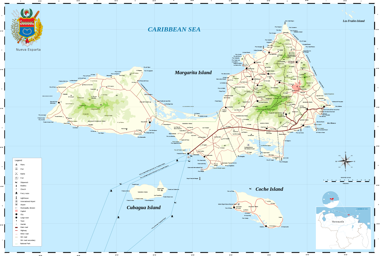
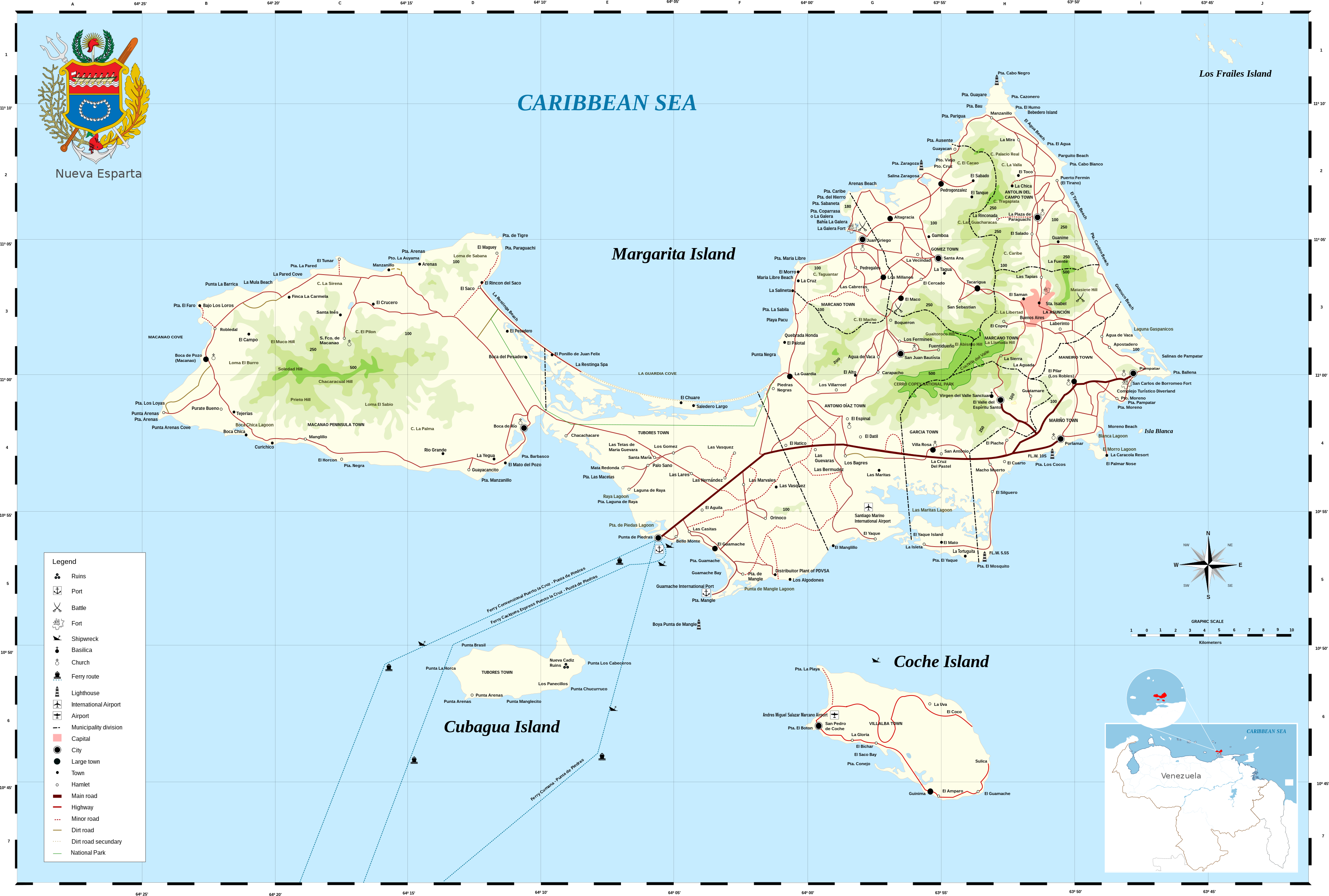
Aragonés: stato Nueba Esparta Bahasa Indonesia: Nueva Esparta Català: Estat de Nueva Esparta Dansk: Nueva Esparta Deutsch: Karte von Nueva Esparta English: Nueva Esparta (New Sparta) is one of the 23 states (estados) of Venezuela. It comprises Margarita Island (by far the largest and most important island), Coche, and uninhabited Cubagua.
The state is the smallest one in area, and is located off the northeast Caribbean coast of Venezuela. It is the only insular state of Venuezuela. Its name comes from the heroísm shown by its inhabitants during the Venezuelan War of Independence, deemed similar to that of the Spartan soldiers of Ancient Greece. The main island of Margarita alone has an area of 934 km². In 1909 the state was constituted and in 1947 the island of Cubagua was added. Its capital city is La Asunción, but the main urban center is Porlamar. Español: Nueva Esparta es un estado federal de Venezuela, ubicado al noreste del país, siendo el único Estado Federal insular y el de menor superficie de la nación.
El estado posee gran cantidad de monumentos históricos, en la iglesia de Santa Ana fue declarada la Tercera República de Venezuela, y, Simón Bolívar, su presidente. El Estado fue designado con ese nombre a partir del 12 de mayo de 1817, con el propósito de hacer un homenaje al heroísmo de los habitantes de la isla de Margarita durante la guerra de Independencia de Venezuela, calificado como "Heroísmo espartano", porque hizo recordar la valentía de los ciudadanos de la capital de la porción de Laconia (Esparta), en la península del Peloponeso, en la antigua Grecia. Aquí nacieron Luis Beltrán Prieto Figueroa, Santiago Mariño y otros grandes personajes de la historia regional y nacional. Français : L’État de Nueva Esparta « Nouvelle Sparte » est un des 23 États (estados) du Venezuela. Il comprend les îles de Margarita (de loin la plus grande et plus importante, avec une surface de 934 km² à elle seule), Coche et Cubagua (inhabitée).
C’est le seul État insulaire du Venezuela, et le plus petit de la région, il est localisé sur la côte antillaise au nord-est du Venezuela. Son nom vient de l’héroïsme montré par ses habitants durant la guerre d’indépendance vénézuelienne, jugé semblable à celui des soldats spartiates de la Grèce antique. L’État a été constitué en 1909 et l’île de Cubagua a été ajoutée en 1947. Sa ville capitale est Asunción, mais le principal centre urbain est Porlamar. Italiano: Nueva Esparta Kernowek: Nueva Esparta Nederlands: Nueva Esparta Norsk bokmål: Nueva Esparta Norsk nynorsk: Nueva Esparta Polski: Nueva Esparta Português: Estado de Nueva Esparta Svenska: Nueva Esparta (Nya Sparta), en delstat i Venezuela. Русский: Нуэва-Эспарта Тоҷикӣ: Иёлоти Нуэва Эспарта 日本語: ベネズエラ、ヌエバ・エスパルタ州の地図。 中文: 新埃斯帕塔州 |
|||
| Datum | ||||
| Bron |
Eigen werk, data obtained traveling across the zone with a GPS. Miniature Venezuela map from File:Venezuela Regiones Administrativas.svg
|
|||
| Auteur | Wilfredor | |||
| Toestemming (Hergebruik van dit bestand) |
|
|||
| Andere versies |
Afgeleide werken van dit bestand: |
|||
| SVG ontwikkeling |


|
Bestandsgeschiedenis
Klik op een datum/tijd om het bestand te zien zoals het destijds was.
| Datum/tijd | Miniatuur | Afmetingen | Gebruiker | Opmerking | |
|---|---|---|---|---|---|
| huidige versie | 23 okt 2015 12:51 | | 3.604 × 2.431 (2,23 MB) | Wilfredor | "lighthuse"->"lighthouse" |
| 22 okt 2015 18:00 |  | 3.604 × 2.431 (2,23 MB) | Wilfredor | Minor road change and Coat of arms update from blazon | |
| 22 okt 2015 16:46 |  | 3.604 × 2.431 (2,43 MB) | Wilfredor | Fixing talk page problems | |
| 22 okt 2015 15:49 |  | 3.604 × 2.431 (2,43 MB) | Wilfredor | severals fixes, I will continue after to lunch | |
| 22 okt 2015 14:13 |  | 3.604 × 2.431 (2,44 MB) | Wilfredor | National Park label | |
| 22 okt 2015 14:09 |  | 3.604 × 2.431 (2,43 MB) | Wilfredor | Minor road, Dirt road, Ferry route (line symbol must be shown). "City" symbol is ellipse. Town and Small town symbols are not logic - small towns look more important as simply towns. National park boundary is not included in legend and not separated fr... | |
| 22 okt 2015 13:03 |  | 3.604 × 2.431 (2,43 MB) | Wilfredor | "Secondary road land" is administrative boundary | |
| 22 okt 2015 12:39 |  | 3.604 × 2.431 (2,43 MB) | Wilfredor | Sunken ship -> Shipwreck | |
| 14 okt 2015 20:04 |  | 3.604 × 2.431 (2,43 MB) | Wilfredor | User created page with UploadWizard |
Bestandsgebruik
Dit bestand wordt op de volgende pagina gebruikt:
Globaal bestandsgebruik
De volgende andere wiki's gebruiken dit bestand:
- Gebruikt op ar.wikipedia.org
- Gebruikt op bg.wikipedia.org
- Gebruikt op el.wikipedia.org
- Gebruikt op en.wikipedia.org
- Margarita Island
- Talk:Margarita Island
- User talk:Wilfredor
- Wikipedia:Featured pictures/Diagrams, drawings, and maps/Maps
- Wikipedia:Graphics Lab/Map workshop/Archive/Feb 2010
- Wikipedia:Featured pictures thumbs/57
- Wikipedia:Featured picture candidates/October-2015
- Wikipedia:Featured picture candidates/Nueva Esparta Map English
- Wikipedia:Wikipedia Signpost/2015-11-04/Featured content
- Wikipedia:Wikipedia Signpost/Single/2015-11-04
- Wikipedia:Picture of the day/August 2018
- Template:POTD/2018-08-11
- Wikipedia:Main Page history/2018 August 11
- Gebruikt op en.wikivoyage.org
- Gebruikt op eo.wikipedia.org
- Gebruikt op fa.wikipedia.org
- Gebruikt op fr.wikipedia.org
- Gebruikt op he.wikipedia.org
- Gebruikt op hy.wikipedia.org
- Gebruikt op id.wikipedia.org
- Gebruikt op ka.wikipedia.org
- Gebruikt op ru.wikipedia.org
- Gebruikt op sd.wikipedia.org
- Gebruikt op sh.wikipedia.org
- Gebruikt op ur.wikipedia.org
- Gebruikt op war.wikipedia.org