Bestand:North Pacific Subtropical Convergence Zone.jpg
Geen hogere resolutie beschikbaar.
North_Pacific_Subtropical_Convergence_Zone.jpg (400 × 290 pixels, bestandsgrootte: 104 kB, MIME-type: image/jpeg)
| Dit is een bestand van Wikimedia Commons. Onderstaande beschrijving komt van de beschrijving van het bestand daar. |


Beschrijving
| Beschrijving |
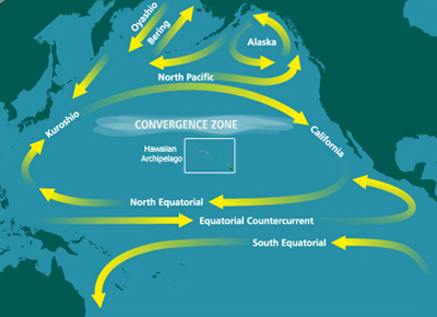
English: Map of the North Pacific Subtropical Convergence Zone (STCZ) within the North Pacific Gyre. Also the location of the Great Pacific Garbage Patch. |
| Datum | Datum onbekend |
| Bron | http://marinedebris.noaa.gov/info/patch.html |
| Auteur | NOAA |
| Toestemming (Hergebruik van dit bestand) |
Public domain |
| Andere versies | Afgeleide werken van dit bestand: North Pacific Subtropical Convergence Zone-es.png |
Licentie
Deze afbeelding is in het publiek domein omdat het materiaal bevat dat oorspronkelijk van de National Oceanic and Atmospheric Administration kwam in de Verenigde Staten en genomen of gemaakt is tijdens de officiële werkzaamheden van een werknemer.
|
Bestandsgeschiedenis
Klik op een datum/tijd om het bestand te zien zoals het destijds was.
| Datum/tijd | Miniatuur | Afmetingen | Gebruiker | Opmerking | |
|---|---|---|---|---|---|
| huidige versie | 29 jun 2010 07:10 | | 400 × 290 (104 kB) | Dcoetzee | Remove watermark reading "WWW.MARINEDEBRIS.NOAA.GOV" |
| 18 mei 2009 09:41 |  | 400 × 290 (107 kB) | Renamed user ixgysjijel | {{Information |Description={{en|1=Map of the North Pacific Subtropical Convergence Zone (STCZ) within the North Pacific Gyre. Also the location of the Great Pacific Garbage Patch.}} |Source=http://marinedebris.noaa.gov/info/patch.html |Author=NOAA |Date= |
Bestandsgebruik
Dit bestand wordt op de volgende pagina gebruikt:
Globaal bestandsgebruik
De volgende andere wiki's gebruiken dit bestand:
- Gebruikt op ar.wikipedia.org
- Gebruikt op ca.wikipedia.org
- Gebruikt op da.wikipedia.org
- Gebruikt op en.wikipedia.org
- Thomas Cavendish
- High-nutrient, low-chlorophyll regions
- North Pacific Gyre
- Great Pacific garbage patch
- Maritime history of California
- Marine plastic pollution
- Boundary current
- Ecosystem of the North Pacific Subtropical Gyre
- User:Horn.kali/sandbox
- United Nations Ocean Conference
- User:Vanisheduser431890/sandbox
- Thomas Cavendish's circumnavigation
- Gebruikt op en.wikiversity.org
- Gebruikt op es.wikipedia.org
- Gebruikt op fa.wikipedia.org
- Gebruikt op fr.wikipedia.org
- Gebruikt op he.wikipedia.org
- Gebruikt op id.wikipedia.org
- Gebruikt op ig.wikipedia.org
- Gebruikt op it.wikipedia.org
- Gebruikt op ja.wikipedia.org
- Gebruikt op ko.wikipedia.org
- Gebruikt op krc.wikipedia.org
- Gebruikt op mdf.wikipedia.org
- Gebruikt op pl.wikipedia.org
- Gebruikt op pt.wikipedia.org
- Gebruikt op ru.wikipedia.org
- Gebruikt op simple.wikipedia.org
- Gebruikt op sl.wikipedia.org
- Gebruikt op sv.wikipedia.org
- Gebruikt op th.wikipedia.org
- Gebruikt op uk.wikipedia.org
Globaal gebruik van dit bestand bekijken.