Bestand:NEC map.svg

Afmetingen van deze voorvertoning van het type PNG van dit SVG-bestand: 781 × 599 pixels Andere resoluties: 313 × 240 pixels | 626 × 480 pixels | 1.001 × 768 pixels | 1.280 × 982 pixels | 2.560 × 1.964 pixels | 1.676 × 1.286 pixels.
Oorspronkelijk bestand (SVG-bestand, nominaal 1.676 × 1.286 pixels, bestandsgrootte: 264 kB)
| Dit is een bestand van Wikimedia Commons. Onderstaande beschrijving komt van de beschrijving van het bestand daar. |
| Beschrijving |
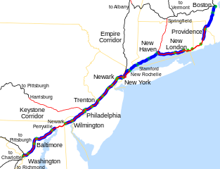
Map of the Northeast Corridor, traced on USGS topos. Legend:
|
||
| Datum | |||
| Bron | Eigen werk; USGS topographic maps | ||
| Auteur | User:SPUI | ||
| Toestemming (Hergebruik van dit bestand) |
|
| Dit werk vrijgegeven in het publieke domein door de auteur, SPUI. Dit is wereldwijd van toepassing. In sommige landen is dit wettelijk niet mogelijk; in die gevallen geldt: |
Bestandsgeschiedenis
Klik op een datum/tijd om het bestand te zien zoals het destijds was.
| Datum/tijd | Miniatuur | Afmetingen | Gebruiker | Opmerking | |
|---|---|---|---|---|---|
| huidige versie | 23 apr 2012 04:45 | | 1.676 × 1.286 (264 kB) | Pi.1415926535 | Wickford Junction service begins tomorrow! |
| 13 jul 2011 05:35 |  | 1.676 × 1.286 (263 kB) | Pi.1415926535 | MBTA Commuter Rail to T.F. Green. | |
| 19 mrt 2007 22:59 |  | 1.676 × 1.286 (257 kB) | NE2 | Oops... I forgot to crop it. | |
| 19 mrt 2007 22:56 |  | 1.898 × 1.711 (243 kB) | NE2 | Changed the color in Massachusetts to reflect the state ownership. | |
| 25 okt 2005 05:12 |  | 1.676 × 1.286 (239 kB) | SPUI~commonswiki | fixed text placement | |
| 25 okt 2005 05:08 |  | 1.676 × 1.286 (235 kB) | SPUI~commonswiki | {{spuimap}} Map of the Northeast Corridor, traced on USGS topos. category:railroad maps category:Amtrak Category:Pennsylvania Railroad Category:New York, New Haven and Hartford Railroad |
Bestandsgebruik
Dit bestand wordt op de volgende pagina gebruikt:
Globaal bestandsgebruik
De volgende andere wiki's gebruiken dit bestand:
- Gebruikt op cs.wikipedia.org
- Gebruikt op da.wikipedia.org
- Gebruikt op de.wikipedia.org
- Gebruikt op en.wikipedia.org
- Gebruikt op es.wikipedia.org
- Gebruikt op fa.wikipedia.org
- Gebruikt op fr.wikipedia.org
- Gebruikt op hu.wikipedia.org
- Gebruikt op id.wikipedia.org
- Gebruikt op it.wikipedia.org
- Gebruikt op ja.wikipedia.org
- Gebruikt op ko.wikipedia.org
- Gebruikt op no.wikipedia.org
- Gebruikt op pt.wikipedia.org
- Gebruikt op vi.wikipedia.org
- Gebruikt op www.wikidata.org
- Gebruikt op zh.wikipedia.org