Bestand:NAS Cubi Point and NS Subic Bay.jpg

Grootte van deze voorvertoning: 800 × 547 pixels. Andere resoluties: 320 × 219 pixels | 640 × 437 pixels | 1.024 × 700 pixels | 1.280 × 875 pixels | 2.780 × 1.900 pixels.
Oorspronkelijk bestand (2.780 × 1.900 pixels, bestandsgrootte: 3,45 MB, MIME-type: image/jpeg)
| Dit is een bestand van Wikimedia Commons. Onderstaande beschrijving komt van de beschrijving van het bestand daar. |
Beschrijving
| Beschrijving |
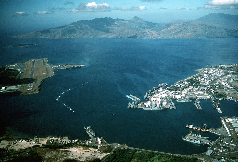
English: Aerial view of the U.S. Navy Naval Station Subic Bay, Philippines, circa in 1990, with Naval Air Station Cubi Point visible on the left.
This photo was most probably taken in January of 1991, during the build-up to Operations DESERT SHIELD & DESERT STORM, but before the 12 June 1991 eruption of Mt. Pinatubo. In addition to the USS Ranger, moored at Leyte Pier, a Tarawa-class LHA is visible in the image, tied up in the maintenance area of the Subic Bay Naval Shipyard. The only Tarawa-class ship in the WestPac at the time was the Tarawa. The other west coast LHAs were both in port undergoing overhaul/maintenance in California (Belleau Wood (LHA 3) in San Diego and Peleliu (LHA 5) in Long Beach. Also visible at Alava Pier, above the Tarawa, is an Iwo Jima-class LPH, and at least seven other amphibious ships (LPD, LSD, LST). This is consistent with two full Amphibious Readiness Groups (ARGs) deployed for Operation DESERT SHIELD/DESERT STORM.Note: The photo is dated, incorrectly, as "1 January 1990". The aircraft carrier USS Ranger (CV 61) is docked at NAS Cubi Point. Ranger was deployed to the Western Pacific from 24 February to 24 August 1989 and to the Western Pacific and the Indian Ocean during the 1991 Gulf War from 8 December 1990 to 8 June 1991. |
|||
| Datum | ca. 1990 | |||
| Bron |
|
|||
| Auteur | PH1(Nac) David R. Sanner, U.S. Navy |
| Cameralocatie | | Deze en andere afbeeldingen in: OpenStreetMap |
|---|
Licentie
Dit bestand is een werk van een zeeman of beambte van de U.S. Navy, gemaakt tijdens diens officiële werkzaamheden. Aangezien het een werk van de Amerikaanse federale overheid betreft, bevindt deze afbeelding zich in het publiek domein.
|
 | |
| Van dit bestand is vastgesteld dat er geen bekende auteursrechtaanspraken op rusten, alle aanverwante en naburige rechten daarbij inbegrepen. | ||
Bestandsgeschiedenis
Klik op een datum/tijd om het bestand te zien zoals het destijds was.
| Datum/tijd | Miniatuur | Afmetingen | Gebruiker | Opmerking | |
|---|---|---|---|---|---|
| huidige versie | 25 apr 2007 03:27 | | 2.780 × 1.900 (3,45 MB) | Dual Freq | {{Information |Description= |Source=[http://www.dodmedia.osd.mil/Assets/Still/1991/Navy/DN-ST-91-11630.JPEG ID:DN-ST-91-11630] |Author=Camera Operator: PH1(NAC) DAVID R. SANNER </br>Service Depicted: Navy An aerial view of the station and, to the left, N |
Bestandsgebruik
Dit bestand wordt op de volgende 2 pagina's gebruikt:
Globaal bestandsgebruik
De volgende andere wiki's gebruiken dit bestand:
- Gebruikt op arz.wikipedia.org
- Gebruikt op ca.wikipedia.org
- Gebruikt op ceb.wikipedia.org
- Gebruikt op en.wikipedia.org
- Gebruikt op fr.wikipedia.org
- Gebruikt op fr.wikivoyage.org
- Gebruikt op it.wikipedia.org
- Gebruikt op ja.wikipedia.org
- Gebruikt op pl.wikipedia.org
- Gebruikt op pt.wikipedia.org
- Gebruikt op sv.wikipedia.org
- Gebruikt op uk.wikipedia.org
- Gebruikt op vi.wikipedia.org
- Gebruikt op www.wikidata.org
- Gebruikt op zh.wikipedia.org