Bestand:Middle East. LOC 95681206.jpg

Grootte van deze voorvertoning: 697 × 599 pixels. Andere resoluties: 279 × 240 pixels | 558 × 480 pixels | 893 × 768 pixels | 1.191 × 1.024 pixels | 2.382 × 2.048 pixels | 7.704 × 6.624 pixels.
Oorspronkelijk bestand (7.704 × 6.624 pixels, bestandsgrootte: 4,6 MB, MIME-type: image/jpeg)
| Dit is een bestand van Wikimedia Commons. Onderstaande beschrijving komt van de beschrijving van het bestand daar. |
Beschrijving
| Beschrijving |
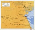
English: "721438 (B01188) 3-91." Shows countries west of Persian Gulf, Kuwait and its surrounding countries, portions of Iraq, Iran, and Saudi Arabia. Also shows de facto boundaries. Available also through the Library of Congress Web site as a raster image. |
||
| Title | [Middle East]. | ||
| Shelf ID | G7420 1991 .U54 | ||
| Datum | |||
| Bron | https://www.loc.gov/item/95681206/ | ||
| Auteur | United States. Central Intelligence Agency | ||
| Toestemming (Hergebruik van dit bestand) |
|
||
| Andere versies |
|
||
| Location | Middle East | ||
| Part of | American Memory · General Maps · Catalog · Geography And Map Division | ||
| Subject | Maps · Middle East |

Licentie
| This image is a work of a Central Intelligence Agency employee, taken or made as part of that person's official duties. As a Work of the United States Government, this image or media is in the public domain in the United States.
|

|
Bestandsgeschiedenis
Klik op een datum/tijd om het bestand te zien zoals het destijds was.
| Datum/tijd | Miniatuur | Afmetingen | Gebruiker | Opmerking | |
|---|---|---|---|---|---|
| huidige versie | 10 mei 2018 02:53 | | 7.704 × 6.624 (4,6 MB) | Fæ | LOC Maps https://www.loc.gov/item/95681206/ #183 |
Bestandsgebruik
Dit bestand wordt op de volgende 3 pagina's gebruikt:
Globaal bestandsgebruik
De volgende andere wiki's gebruiken dit bestand:
- Gebruikt op www.wikidata.org