Bestand:Marquette County, Mich.svg

Afmetingen van deze voorvertoning van het type PNG van dit SVG-bestand: 547 × 600 pixels Andere resoluties: 219 × 240 pixels | 438 × 480 pixels | 701 × 768 pixels | 934 × 1.024 pixels | 1.868 × 2.048 pixels | 635 × 696 pixels.
Oorspronkelijk bestand (SVG-bestand, nominaal 635 × 696 pixels, bestandsgrootte: 330 kB)
| Dit is een bestand van Wikimedia Commons. Onderstaande beschrijving komt van de beschrijving van het bestand daar. |
Beschrijving
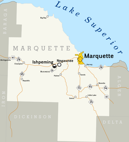
| Beschrijving | Map of Marquette County, Michigan. |
| Datum | |
| Bron | Created by me. Based on data collected from [1] which was loaded into Quantum GIS 0.11.0 and used to export a PNG. This was then loaded into Inkscape, the county outline and roads were traced, and the other map symbols placed by hand. Most text is set in Pigiarniq, a font produced by the government of the Canadian province of Nunavut. |
| Auteur | Scott Nazelrod |
| Toestemming (Hergebruik van dit bestand) |
CC-BY-SA |
Licentie
Dit bestand is gelicenseerd onder de Creative Commons-licentie Naamsvermelding-Gelijk delen 3.0 Unported
- De gebruiker mag:
- Delen – het werk kopiëren, verspreiden en doorgeven
- Remixen – afgeleide werken maken
- Onder de volgende voorwaarden:
- naamsvermelding – U moet op een gepaste manier aan naamsvermelding doen, een link naar de licentie geven, en aangeven of er wijzigingen in het werk zijn aangebracht. U mag dit op elke redelijke manier doen, maar niet zodanig dat de indruk wordt gewekt dat de licentiegever instemt met uw werk of uw gebruik van zijn werk.
- Gelijk delen – Als u het werk heeft geremixt, veranderd, of erop heeft voortgebouwd, moet u het gewijzigde materiaal verspreiden onder dezelfde licentie als het oorspronkelijke werk, of een daarmee compatibele licentie.
Bestandsgeschiedenis
Klik op een datum/tijd om het bestand te zien zoals het destijds was.
| Datum/tijd | Miniatuur | Afmetingen | Gebruiker | Opmerking | |
|---|---|---|---|---|---|
| huidige versie | 23 sep 2008 23:09 | | 635 × 696 (330 kB) | Scott5114 | Tweak map based on comments from an actual Yooper |
| 23 sep 2008 19:16 |  | 635 × 696 (313 kB) | Scott5114 | {{Information |Description=Map of Marquette County, Michigan. |Source=Created by me. Based on data collected from [http://www.mcgi.state.mi.us/mgdl/?action=thm] which was loaded into Quantum GIS 0.11.0 and used to export a PNG. This was then loaded into I |
Bestandsgebruik
Dit bestand wordt op de volgende pagina gebruikt:
Globaal bestandsgebruik
De volgende andere wiki's gebruiken dit bestand:
- Gebruikt op en.wikipedia.org
- Marquette County, Michigan
- Wikipedia:Former featured and good topics
- List of state trunkline highways in Marquette County, Michigan
- User:Scott5114/Map requests
- Wikipedia:Featured and good topic candidates/Featured log/June 2009
- Wikipedia:Featured and good topic candidates/State highways in Marquette County, Michigan
- Wikipedia:Featured topics/State highways in Marquette County, Michigan
- Wikipedia:Featured and good topic removal candidates/2010 log
- Wikipedia:Featured and good topic removal candidates/State highways in Marquette County, Michigan/archive1
- Gebruikt op ja.wikipedia.org
- Gebruikt op www.wikidata.org