Bestand:Map of North America with the Western Interior Seaway during the Campanian (Upper Cretaceous).png

Grootte van deze voorvertoning: 488 × 600 pixels. Andere resoluties: 195 × 240 pixels | 390 × 480 pixels | 625 × 768 pixels | 833 × 1.024 pixels | 1.945 × 2.391 pixels.
Oorspronkelijk bestand (1.945 × 2.391 pixels, bestandsgrootte: 3,95 MB, MIME-type: image/png)
Dit is een bestand van Wikimedia Commons.
Onderstaande beschrijving komt van de beschrijving van het bestand daar.
Onderstaande beschrijving komt van de beschrijving van het bestand daar.
.png)
Beschrijving
| Beschrijving |
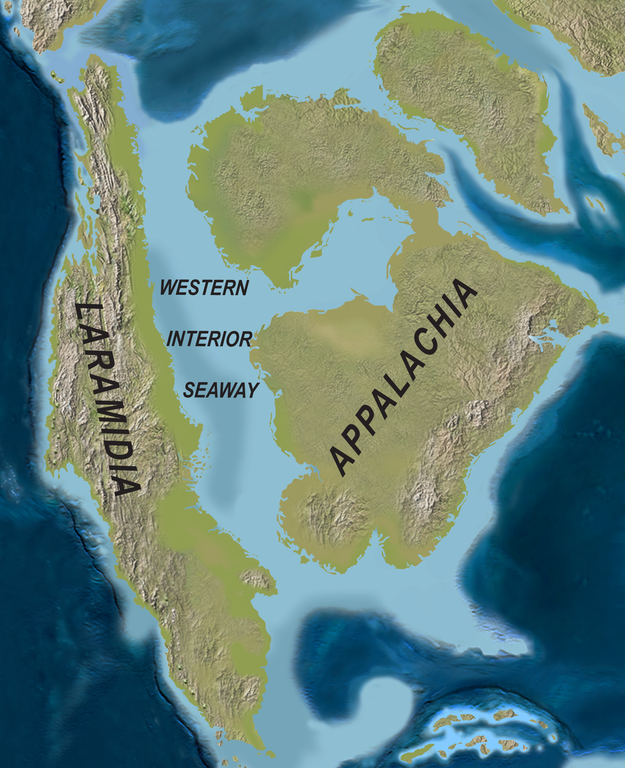
English: Map of North America with the Western Interior Seaway during the Campanian (Upper Cretaceous). Paleogeography of North America during the late Campanian Stage of the Late Cretaceous (∼75 Ma). Modified after Blakey.
Deutsch: Karte von Nordamerika mit dem Western Interior Seaway während des Campaniums (Obere Kreide) |
| Datum | |
| Bron | http://www.plosone.org/article/info%3Adoi%2F10.1371%2Fjournal.pone.0012292 |
| Auteur | Scott D. Sampson, Mark A. Loewen, Andrew A. Farke, Eric M. Roberts, Catherine A. Forster, Joshua A. Smith, Alan L. Titus |
| Toestemming (Hergebruik van dit bestand) |
http://www.plosbiology.org/static/license.action |
Licentie
Dit bestand is gelicenseerd onder de Creative Commons Naamsvermelding 4.0 Internationaal licentie.
- De gebruiker mag:
- Delen – het werk kopiëren, verspreiden en doorgeven
- Remixen – afgeleide werken maken
- Onder de volgende voorwaarden:
- naamsvermelding – U moet op een gepaste manier aan naamsvermelding doen, een link naar de licentie geven, en aangeven of er wijzigingen in het werk zijn aangebracht. U mag dit op elke redelijke manier doen, maar niet zodanig dat de indruk wordt gewekt dat de licentiegever instemt met uw werk of uw gebruik van zijn werk.
Bestandsgeschiedenis
Klik op een datum/tijd om het bestand te zien zoals het destijds was.
| Datum/tijd | Miniatuur | Afmetingen | Gebruiker | Opmerking | |
|---|---|---|---|---|---|
| huidige versie | 1 apr 2020 23:08 | | 1.945 × 2.391 (3,95 MB) | FunkMonk | {{Information |Description = {{en|1=Map of North America with the Western Interior Seaway during the Campanian (Upper Cretaceous). Paleogeography of North America during the late Campanian Stage of the Late Cretaceous (∼75 Ma). Modified after Blakey.}} {{de|1=Karte von Nordamerika mit dem Western Interior Seaway während des Campaniums (Obere Kreide)}} |Source =http://www.plosone.org/article/info%3Adoi%2F10.1371%2Fjournal.pone.0012292 |Author =Scott D. Sampson, Mark A. Loewe... |
Bestandsgebruik
Dit bestand wordt op de volgende 2 pagina's gebruikt:
Globaal bestandsgebruik
De volgende andere wiki's gebruiken dit bestand:
- Gebruikt op de.wiktionary.org
- Gebruikt op en.wikipedia.org
- Gebruikt op fa.wikipedia.org
- Gebruikt op fr.wikipedia.org
- Gebruikt op id.wikipedia.org
- Gebruikt op it.wikipedia.org
- Gebruikt op ne.wikipedia.org
- Gebruikt op pl.wikipedia.org
- Gebruikt op pl.wiktionary.org
- Gebruikt op pt.wikipedia.org
- Gebruikt op ru.wikipedia.org
- Gebruikt op tr.wikipedia.org
- Gebruikt op uk.wikipedia.org
- Gebruikt op zh.wikipedia.org
.png)