Bestand:Map of Enga Province, Papua New Guinea.pdf

Afmetingen van deze voorvertoning van het type JPG van dit PDF-bestand: 800 × 520 pixels Andere resoluties: 320 × 208 pixels | 640 × 416 pixels | 1.024 × 666 pixels | 1.377 × 895 pixels.
Oorspronkelijk bestand (1.377 × 895 pixels, bestandsgrootte: 5,26 MB, MIME-type: application/pdf)
Dit is een bestand van Wikimedia Commons.
Onderstaande beschrijving komt van de beschrijving van het bestand daar.
Onderstaande beschrijving komt van de beschrijving van het bestand daar.
Beschrijving
| Beschrijving |
English: A map of Enga Province in Papua New Guinea, made in 2020. It contains several layers: elevation, roads, and major settlements. It was produced by Nelson Minar from data sources including OpenStreetMap, Humanitarian Data Exchange, OpenDEM, and SRTM. It was published in the book "The Absent Presence of the State in Large-Scale Resource Extraction Projects", in Alex Golub's chapter "Restraint Without Control". |
| Datum | |
| Bron | Eigen werk |
| Auteur | Nelson Minar |
| Cameralocatie | | Deze en andere afbeeldingen in: OpenStreetMap |
|---|
Licentie
Ik, de auteursrechthebbende van dit werk, maak het hierbij onder de volgende licentie beschikbaar:
Dit bestand is gelicenseerd onder de Creative Commons Naamsvermelding-GelijkDelen 4.0 Internationaal licentie.
- De gebruiker mag:
- Delen – het werk kopiëren, verspreiden en doorgeven
- Remixen – afgeleide werken maken
- Onder de volgende voorwaarden:
- naamsvermelding – U moet op een gepaste manier aan naamsvermelding doen, een link naar de licentie geven, en aangeven of er wijzigingen in het werk zijn aangebracht. U mag dit op elke redelijke manier doen, maar niet zodanig dat de indruk wordt gewekt dat de licentiegever instemt met uw werk of uw gebruik van zijn werk.
- Gelijk delen – Als u het werk heeft geremixt, veranderd, of erop heeft voortgebouwd, moet u het gewijzigde materiaal verspreiden onder dezelfde licentie als het oorspronkelijke werk, of een daarmee compatibele licentie.
Bestandsgeschiedenis
Klik op een datum/tijd om het bestand te zien zoals het destijds was.
| Datum/tijd | Miniatuur | Afmetingen | Gebruiker | Opmerking | |
|---|---|---|---|---|---|
| huidige versie | 4 jan 2024 00:59 | 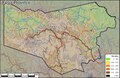 | 1.377 × 895 (5,26 MB) | Nelson Minar | Uploaded own work with UploadWizard |
Bestandsgebruik
Dit bestand wordt op de volgende pagina gebruikt:
Globaal bestandsgebruik
De volgende andere wiki's gebruiken dit bestand:
- Gebruikt op ckb.wikipedia.org
- Gebruikt op en.wikipedia.org
- Gebruikt op pt.wikipedia.org