Bestand:Map of British plantations of Ireland, 1550–1610.png

Geen hogere resolutie beschikbaar.
Map_of_British_plantations_of_Ireland,_1550–1610.png (466 × 565 pixels, bestandsgrootte: 7 kB, MIME-type: image/png)
| Dit is een bestand van Wikimedia Commons. Onderstaande beschrijving komt van de beschrijving van het bestand daar. |
Beschrijving
| Beschrijving |
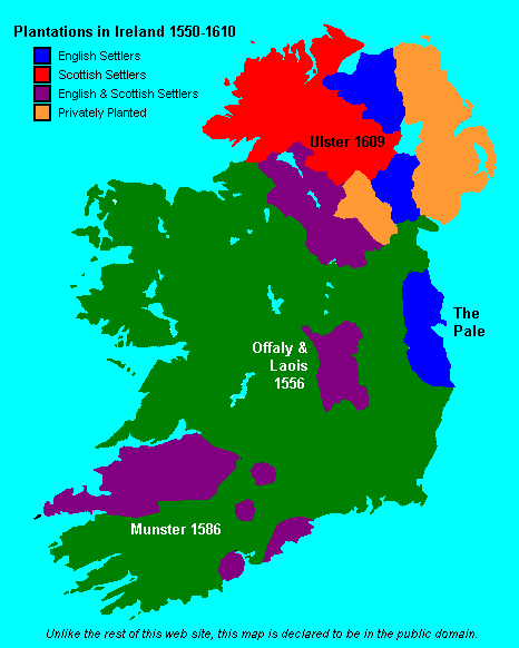
English: Map showing the major British crown-organised and private-sector "plantations" (colonies) in Ireland from ca. 1550 to 1610. Colour-coded as to Scottish, English or a mixture (other than it is not clear that the privately organized plantations in Ulster varied in composition, but heavy toward the Scots side). This file is supplied as requested PNG replacement for an undesirable GIF, though the entire thing would be better redone as an SVG. |
| Datum | (original 2007-05-09) |
| Bron | Proximally, from GIF version; ultimately, from http://www.wesleyjohnston.com/users/ireland/maps/historical/map1609.gif |
| Auteur | www.wesleyjohnston.com |
| Toestemming (Hergebruik van dit bestand) |
Public domain by declaration of original creator (see notice at bottom of original GIF-format upload) |
| Andere versies |
|

Licentie
License declared by original uploader User:NielsF:
| Ik, de auteursrechthebbende van dit werk, geef dit werk vrij in het publieke domein. Dit is wereldwijd van toepassing. In sommige landen is dit wettelijk niet mogelijk; in die gevallen geldt: Ik sta iedereen toe dit werk voor eender welk doel te gebruiken, zonder enige voorwaarden, tenzij zulke voorwaarden door de wet worden voorgeschreven. |
Bestandsgeschiedenis
Klik op een datum/tijd om het bestand te zien zoals het destijds was.
| Datum/tijd | Miniatuur | Afmetingen | Gebruiker | Opmerking | |
|---|---|---|---|---|---|
| huidige versie | 8 jun 2024 19:04 | | 466 × 565 (7 kB) | SMcCandlish | {{Information |Description={{en|Map showing the major British crown-organised and private-sector "plantations" (colonies) in Ireland from ca. 1550 to 1610. Colour-coded as to Scottish, English or a mixture (other than it is not clear that the privately organized plantation varied in composition; the one in Ulster predominantly Scots settlers, the more southerly ones predominantly English). This file is supplied as requested PNG replacement for an undesirable GIF, though the entire thing would... |
Bestandsgebruik
Dit bestand wordt op de volgende 4 pagina's gebruikt:
Globaal bestandsgebruik
De volgende andere wiki's gebruiken dit bestand:
- Gebruikt op ar.wikipedia.org
- Gebruikt op da.wikipedia.org
- Gebruikt op de.wikipedia.org
- Gebruikt op en.wikipedia.org
- Gebruikt op ru.wikipedia.org
- Gebruikt op simple.wikipedia.org