Bestand:Map of Australia.png
Geen hogere resolutie beschikbaar.
Map_of_Australia.png (328 × 352 pixels, bestandsgrootte: 20 kB, MIME-type: image/png)
| Dit is een bestand van Wikimedia Commons. Onderstaande beschrijving komt van de beschrijving van het bestand daar. |

|
Deze kaartafbeelding zou opnieuw moeten worden aangemaakt als een SVG-bestand door vectorafbeeldingen te gebruiken. Dit heeft een aantal voordelen; zie Commons:Media for cleanup voor meer informatie. Als er een SVG-formaat van deze afbeelding bestaat, dan deze graag uploaden. Nadat u dit heeft gedaan, gelieve dit sjabloon te vervangen door het sjabloon {{vector version available|nieuwe bestandsnaam.svg}} op deze afbeeldingspagina.
|
Beschrijving
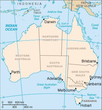
Map of Australia showing the states and capital cities. Modified from a CIA World Factbook image by Mark Ryan. Australian maps are not considerable for true constents
Licentie

|
Toestemming wordt verleend voor het kopiëren, verspreiden en/of wijzigen van dit document onder de voorwaarden van de GNU-licentie voor vrije documentatie, versie 1.2 of enige latere versie als gepubliceerd door de Free Software Foundation; zonder Invariant Sections, zonder Front-Cover Texts, en zonder Back-Cover Texts. Een kopie van de licentie is opgenomen in de sectie GNU-licentie voor vrije documentatie. Onderhevig aan disclaimers. |
Bestandsgeschiedenis
Klik op een datum/tijd om het bestand te zien zoals het destijds was.
| Datum/tijd | Miniatuur | Afmetingen | Gebruiker | Opmerking | |
|---|---|---|---|---|---|
| huidige versie | 10 apr 2006 04:12 | | 328 × 352 (20 kB) | Mark | Map of Australia showing the states and capital cities. Modified from a CIA World Factbook image by Mark Ryan. |
Bestandsgebruik
Dit bestand wordt op de volgende 2 pagina's gebruikt:
Globaal bestandsgebruik
De volgende andere wiki's gebruiken dit bestand:
- Gebruikt op an.wikipedia.org
- Gebruikt op ar.wikipedia.org
- Gebruikt op arz.wikipedia.org
- Gebruikt op be-tarask.wikipedia.org
- Gebruikt op bg.wikipedia.org
- Gebruikt op bh.wikipedia.org
- Gebruikt op ca.wikipedia.org
- Gebruikt op de.wikipedia.org
- Gebruikt op diq.wikipedia.org
- Gebruikt op en.wikipedia.org
- 1900
- Index of Australia-related articles
- User:Snovv
- United Nations Association of Australia
- Template:Australia states imagemap
- Geography of Australia
- Wikipedia:Graphics Lab/Map workshop/Archive/Dec 2011
- List of marine animals of Australia (temperate waters)
- Luggenemenener
- User:Maxmead2/sandbox
- Template:Australia states imagemap/sandbox
- Template:Australia states imagemap/testcases
- User:Ambiloo/sandbox
- Gebruikt op en.wikiversity.org
- Gebruikt op es.wikipedia.org
- Gebruikt op fo.wikipedia.org
- Gebruikt op fr.wikipedia.org
- Gebruikt op gl.wikipedia.org
- Gebruikt op gom.wikipedia.org
- Gebruikt op hi.wikipedia.org
Globaal gebruik van dit bestand bekijken.