Bestand:Map indicating Coronation Gulf, Nunavut, Canada.png
Map_indicating_Coronation_Gulf,_Nunavut,_Canada.png (415 × 370 pixels, bestandsgrootte: 65 kB, MIME-type: image/png)
| Dit is een bestand van Wikimedia Commons. Onderstaande beschrijving komt van de beschrijving van het bestand daar. |
Beschrijving
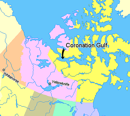
Map indicating Coronation Gulf, Nunavut, Canada.
© Her Majesty the Queen in Right of Canada, Department of Natural Resources. All rights reserved.
Licence Agreement
Licentie

|
De copyrighthouder van dit werk staat iedereen toe om het te gebruiken voor elk doel inclusief onbeperkte herdistributie, commercieel gebruik en wijziging.
Opmerkingen bij het gebruik:
|
Bestandsgeschiedenis
Klik op een datum/tijd om het bestand te zien zoals het destijds was.
| Datum/tijd | Miniatuur | Afmetingen | Gebruiker | Opmerking | |
|---|---|---|---|---|---|
| huidige versie | 21 mrt 2006 06:01 | | 415 × 370 (65 kB) | David Kernow~commonswiki | Map indicating Coronation Gulf, Nunavut, Canada. {{legend|#ffff66|Nunavut}} {{legend|#ffccff|Northwest Territories}} {{legend|#ffcc99|Yukon Territory}} {{legend|#ffff99|British Columbia}} {{legend|#cccc99|Alberta}} {{legend|#99ffcc| |
Bestandsgebruik
Dit bestand wordt op de volgende pagina gebruikt:
Globaal bestandsgebruik
De volgende andere wiki's gebruiken dit bestand:
- Gebruikt op ar.wikipedia.org
- Gebruikt op ckb.wikipedia.org
- Gebruikt op de.wikipedia.org
- Gebruikt op en.wikipedia.org
- Gebruikt op en.wiktionary.org
- Gebruikt op es.wikipedia.org
- Gebruikt op et.wikipedia.org
- Gebruikt op fa.wikipedia.org
- Gebruikt op fi.wikipedia.org
- Gebruikt op fr.wikipedia.org
- Gebruikt op ja.wikipedia.org
- Gebruikt op ml.wikipedia.org