Bestand:Map Lesotho SRTM.pdf
Afmetingen van deze voorvertoning van het type JPG van dit PDF-bestand: 800 × 565 pixels Andere resoluties: 320 × 226 pixels | 640 × 452 pixels | 1.024 × 723 pixels | 1.280 × 904 pixels | 1.754 × 1.239 pixels.
Oorspronkelijk bestand (1.754 × 1.239 pixels, bestandsgrootte: 1,88 MB, MIME-type: application/pdf)
| Dit is een bestand van Wikimedia Commons. Onderstaande beschrijving komt van de beschrijving van het bestand daar. |

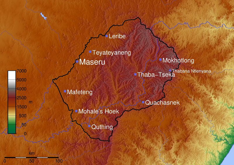
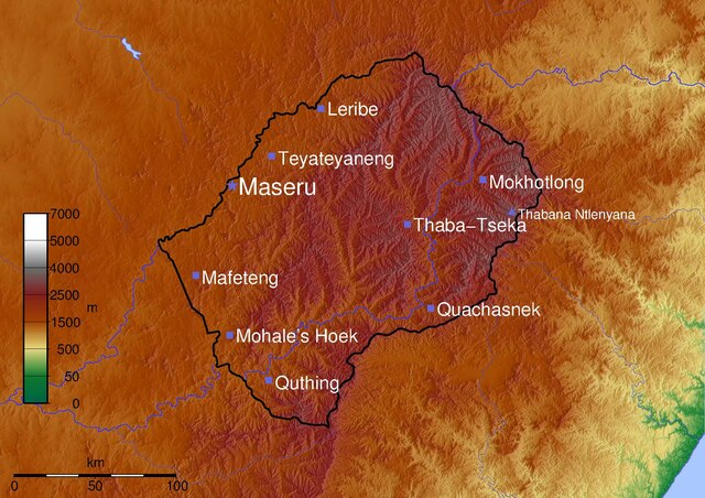
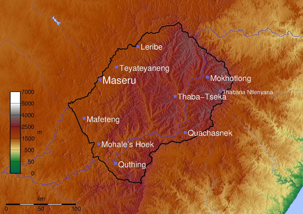
Topographical map of Lesotho.
© 2005 Médéric Boquien (Med)
Topography: National Geospatial-Intelligence Agency and NASA, [1]
Mapping: Generic Mapping Tools.
Dit bestand is gelicenseerd onder de Creative Commons-licentie Naamsvermelding-Gelijk delen 2.0 Unported
- De gebruiker mag:
- Delen – het werk kopiëren, verspreiden en doorgeven
- Remixen – afgeleide werken maken
- Onder de volgende voorwaarden:
- naamsvermelding – U moet op een gepaste manier aan naamsvermelding doen, een link naar de licentie geven, en aangeven of er wijzigingen in het werk zijn aangebracht. U mag dit op elke redelijke manier doen, maar niet zodanig dat de indruk wordt gewekt dat de licentiegever instemt met uw werk of uw gebruik van zijn werk.
- Gelijk delen – Als u het werk heeft geremixt, veranderd, of erop heeft voortgebouwd, moet u het gewijzigde materiaal verspreiden onder dezelfde licentie als het oorspronkelijke werk, of een daarmee compatibele licentie.
#!/bin/sh
RFLAG="-R26/30.5/-31.05/-28.2"
FORMAT=""
PROJECTION="$RFLAG -JM29.7 $FORMAT"
CITY_TEXT_COLOR=255/255/255
CITY_SYMBOL="-Ss.4 -G102/102/220"
CAPITAL_SYMBOL="-Sa.5 -G102/102/220"
PEAK_SYMBOL="-St.4 -G102/102/220"
PALETTE=mountains2.cpt

PSFILE=lesotho.ps
PNGFILE=lesotho.png

gmtset ANNOT_FONT_SIZE 16p LABEL_FONT_SIZE 16p
grdgradient sortie.grd -Ne.3 -A100 -M -GLesotho_i5.grd
grdimage -Ei -ILesotho_i5.grd -C$PALETTE $PROJECTION sortie.grd -K > $PSFILE

RIVERS="\
  -I1/0.5p/50/50/255\
  -I2/0.4p/50/50/255\
  -I3/0.3p/50/50/255\
  -I4/0.2p/50/50/255\
  -I5/0.4p,-/50/50/255\
  -I6/0.3p,-/50/50/255\
  -I7/0.2p,-/50/50/255\
  -I8/1p/50/50/255"

SCALE=-Lfx4/1/-29.7/100k

pscoast $PROJECTION\
  -Df \
  -W0.5p/100/100/200 \
  -N1/2p \
  -S170/200/255\
  $SCALE\
   -O -K\
  >> $PSFILE

psscale -D1/8/8/1 -C$PALETTE -B:m: -L -O -K $FORMAT >>$PSFILE

recode utf8..iso8859-1 < lesotho_cities.txt | psxy  $PROJECTION $CITY_SYMBOL -O -K >> $PSFILE
recode utf8..iso8859-1 < lesotho_capital.txt | psxy  $PROJECTION $CAPITAL_SYMBOL -O -K >> $PSFILE
recode utf8..iso8859-1 < lesotho_peaks.txt | psxy  $PROJECTION $PEAK_SYMBOL -O -K >> $PSFILE

recode utf8..iso8859-1 < lesotho_cities.txt | pstext $PROJECTION -G$CITY_TEXT_COLOR -Dj0.25 -O  -K >> $PSFILE
recode utf8..iso8859-1 < lesotho_capital.txt | pstext $PROJECTION -G$CITY_TEXT_COLOR -Dj0.25 -O -K  >> $PSFILE
recode utf8..iso8859-1 < lesotho_peaks.txt | pstext $PROJECTION -G$CITY_TEXT_COLOR -Dj0.25 -O  >> $PSFILE

epstopdf $PSFILE
GS_OPTIONS="-dTextAlphaBits=2 -dGraphicsAlphaBits=2"
export GS_OPTIONS
pstopnm -portrait -ysize=2048 -xborder=0 -yborder=0 -stdout -ppm  $PSFILE | pnmtopng > $PNGFILE
#File mountains2.cpt
#COLOR_MODEL = RGB
#
0       0       97      71      50      16      122     47
50      16      122     47      500     232     215     125
500     232     215     125     1500    161     67      0
1500    161     67      0       2500    130     30      30
2500    130     30      30      4000    110     110     110
4000    110     110     110     5000    255     255     255
5000    255     255     255     7000    255     255     255
N 0 97 71
F 255 0 0
B 0 97 71
lesotho_capital.txt:
27.4833333 -29.3166667 28 0 0 LM Maseru
lesotho_cities.txt:
27.7333333  -29.15 22 0 0 LM Teyateyaneng
28.05  -28.8833333 22 0 0 LM Leribe
29.0833333  -29.2833333 22 0 0 LM Mokhotlong
28.6  -29.5333333 22 0 0 LM Thaba-Tseka
28.75  -30.0 22 0 0 LM Quachasnek
27.7166667  -30.4 22 0 0 LM Quthing
27.4666667  -30.15 22 0 0 LM Mohale's Hoek
27.25  -29.8166667 22 0 0 LM Mafeteng
lesotho_peaks.txt:
29.2666667 -29.4666667 16 0 0 LM Thabana Ntlenyana
Bestandsgeschiedenis
Klik op een datum/tijd om het bestand te zien zoals het destijds was.
| Datum/tijd | Miniatuur | Afmetingen | Gebruiker | Opmerking | |
|---|---|---|---|---|---|
| huidige versie | 12 jun 2005 23:43 |  | 1.754 × 1.239 (1,88 MB) | Med | 450px|right|Topographical map of Lesotho Topographical map of Lesotho. © 2005 Médéric Boquien (Med) '''Topography:''' National Geospatial-Intelligence Agency |
Bestandsgebruik
Dit bestand wordt op de volgende pagina gebruikt: