Bestand:Main-Karte-160710.jpg

Grootte van deze voorvertoning: 800 × 560 pixels. Andere resoluties: 320 × 224 pixels | 640 × 448 pixels | 1.024 × 716 pixels | 1.280 × 896 pixels | 2.560 × 1.791 pixels | 3.000 × 2.099 pixels.
Oorspronkelijk bestand (3.000 × 2.099 pixels, bestandsgrootte: 3,28 MB, MIME-type: image/jpeg)
| Dit is een bestand van Wikimedia Commons. Onderstaande beschrijving komt van de beschrijving van het bestand daar. |
Beschrijving
| Beschrijving |
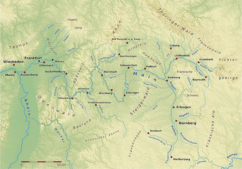
Karte des Verlaufs des Flusses Main Erstellt unter Zuhilfenahme von SRTM-Daten, Quantum GIS, Generic Mapping Tools, GPS-Trackmaker |
| Datum | |
| Bron | Eigen werk |
| Auteur | BerndH |
| Toestemming (Hergebruik van dit bestand) |
CC/GFDL |
Licentie
Ik, de auteursrechthebbende van dit werk, maak het hierbij onder de volgende licenties beschikbaar:
Dit bestand is gelicenseerd onder de Creative Commons-licentie Naamsvermelding-Gelijk delen 3.0 Unported
- De gebruiker mag:
- Delen – het werk kopiëren, verspreiden en doorgeven
- Remixen – afgeleide werken maken
- Onder de volgende voorwaarden:
- naamsvermelding – U moet op een gepaste manier aan naamsvermelding doen, een link naar de licentie geven, en aangeven of er wijzigingen in het werk zijn aangebracht. U mag dit op elke redelijke manier doen, maar niet zodanig dat de indruk wordt gewekt dat de licentiegever instemt met uw werk of uw gebruik van zijn werk.
- Gelijk delen – Als u het werk heeft geremixt, veranderd, of erop heeft voortgebouwd, moet u het gewijzigde materiaal verspreiden onder dezelfde licentie als het oorspronkelijke werk, of een daarmee compatibele licentie.

|
Toestemming wordt verleend voor het kopiëren, verspreiden en/of wijzigen van dit document onder de voorwaarden van de GNU-licentie voor vrije documentatie, versie 1.2 of enige latere versie als gepubliceerd door de Free Software Foundation; zonder Invariant Sections, zonder Front-Cover Texts, en zonder Back-Cover Texts. Een kopie van de licentie is opgenomen in de sectie GNU-licentie voor vrije documentatie. |
U mag zelf één van de licenties kiezen.
Bestandsgeschiedenis
Klik op een datum/tijd om het bestand te zien zoals het destijds was.
| Datum/tijd | Miniatuur | Afmetingen | Gebruiker | Opmerking | |
|---|---|---|---|---|---|
| huidige versie | 5 jan 2021 22:01 | | 3.000 × 2.099 (3,28 MB) | NordNordWest | Haßfurt -> Haßfurt |
| 16 jul 2010 19:14 |  | 3.000 × 2.099 (4,99 MB) | BerndH | {{Information |Description= Karte des Verlaufs des Flusses Main<br/>Erstellt unter Zuhilfenahme von SRTM-Daten, Quantum GIS, Generic Mapping Tools, GPS-Trackmaker |Source={{own}} |Date= 16. Juli 2010 |Author=BerndH |Permission= CC/GFDL |ot |
Bestandsgebruik
Dit bestand wordt op de volgende pagina gebruikt:
Globaal bestandsgebruik
De volgende andere wiki's gebruiken dit bestand:
- Gebruikt op af.wikipedia.org
- Gebruikt op als.wikipedia.org
- Gebruikt op de.wikipedia.org
- Gebruikt op de.wikibooks.org
- Gebruikt op en.wikipedia.org
- Gebruikt op es.wikipedia.org
- Gebruikt op frr.wikipedia.org
- Gebruikt op fr.wikipedia.org
- Gebruikt op fy.wikipedia.org
- Gebruikt op he.wikipedia.org
- Gebruikt op incubator.wikimedia.org
- Gebruikt op li.wikipedia.org
- Gebruikt op lmo.wikipedia.org
- Gebruikt op lv.wikipedia.org
- Gebruikt op ml.wikipedia.org
- Gebruikt op mt.wikipedia.org
- Gebruikt op no.wikipedia.org
- Gebruikt op pl.wikipedia.org
- Gebruikt op sl.wikipedia.org
- Gebruikt op sr.wikipedia.org
- Gebruikt op stq.wikipedia.org
- Gebruikt op th.wikipedia.org
- Gebruikt op tr.wikipedia.org
- Gebruikt op www.wikidata.org
- Gebruikt op xmf.wikipedia.org
- Gebruikt op zh.wikipedia.org