Bestand:Mackinac Island topographic map-en.svg

Afmetingen van deze voorvertoning van het type PNG van dit SVG-bestand: 545 × 600 pixels Andere resoluties: 218 × 240 pixels | 436 × 480 pixels | 698 × 768 pixels | 931 × 1.024 pixels | 1.862 × 2.048 pixels | 1.200 × 1.320 pixels.
Oorspronkelijk bestand (SVG-bestand, nominaal 1.200 × 1.320 pixels, bestandsgrootte: 457 kB)
| Dit is een bestand van Wikimedia Commons. Onderstaande beschrijving komt van de beschrijving van het bestand daar. |
Beschrijving
| Cameralocatie | | Deze en andere afbeeldingen in: OpenStreetMap |
|---|
| Beschrijving |
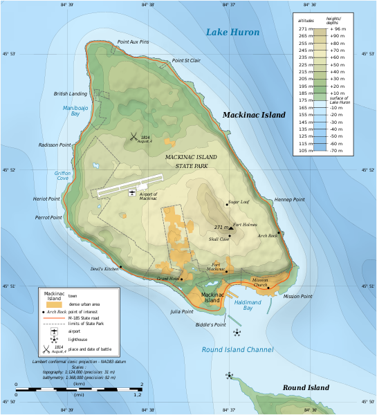
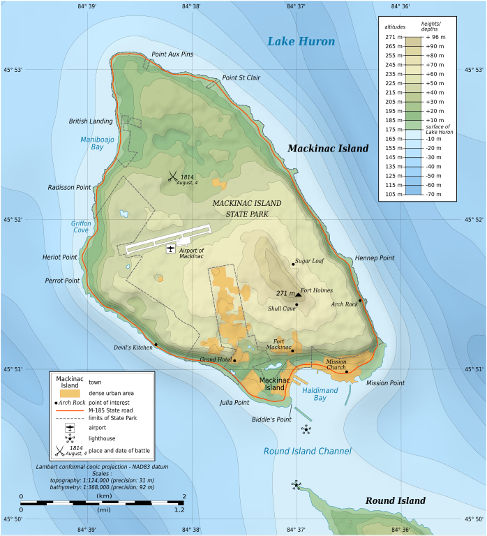
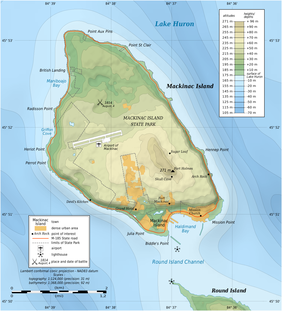
English: Topographic map in English of Mackinac Island, Lake Huron, Michigan, USA.
Note: The shaded relief is a raster image embedded in the SVG file. Français : Carte topographique en anglais de l'Île Mackinac, Lac Huron, Michigan, États-Unis. Note : Les ombres du relief sont une image bitmap embarquée dans le fichier SVG. Lambert conformal conic projection – NAD83 datum
|
||
| Datum | |||
| Bron |
Eigen werk
|
||
| Auteur | Eric Gaba (Sting - fr:Sting) | ||
| Toestemming (Hergebruik van dit bestand) |
|
||
| Andere versies |
|


|
Dit SVG-bestand maakt gebruik van geïntegreerde tekst die gemakkelijk kan worden vertaald naar uw taal met een SVG editor, een tekstverwerker of het hulpmiddel SVG Translate. Uitleg |
Licentie
Ik, de auteursrechthebbende van dit werk, maak het hierbij onder de volgende licenties beschikbaar:

|
Toestemming wordt verleend voor het kopiëren, verspreiden en/of wijzigen van dit document onder de voorwaarden van de GNU-licentie voor vrije documentatie, versie 1.2 of enige latere versie als gepubliceerd door de Free Software Foundation; zonder Invariant Sections, zonder Front-Cover Texts, en zonder Back-Cover Texts. Een kopie van de licentie is opgenomen in de sectie GNU-licentie voor vrije documentatie. |
Dit bestand is gelicenseerd onder de Creative Commons-licentie Naamsvermelding-Gelijk delen 3.0 Unported
- De gebruiker mag:
- Delen – het werk kopiëren, verspreiden en doorgeven
- Remixen – afgeleide werken maken
- Onder de volgende voorwaarden:
- naamsvermelding – U moet op een gepaste manier aan naamsvermelding doen, een link naar de licentie geven, en aangeven of er wijzigingen in het werk zijn aangebracht. U mag dit op elke redelijke manier doen, maar niet zodanig dat de indruk wordt gewekt dat de licentiegever instemt met uw werk of uw gebruik van zijn werk.
- Gelijk delen – Als u het werk heeft geremixt, veranderd, of erop heeft voortgebouwd, moet u het gewijzigde materiaal verspreiden onder dezelfde licentie als het oorspronkelijke werk, of een daarmee compatibele licentie.
U mag zelf één van de licenties kiezen.
Bestandsgeschiedenis
Klik op een datum/tijd om het bestand te zien zoals het destijds was.
| Datum/tijd | Miniatuur | Afmetingen | Gebruiker | Opmerking | |
|---|---|---|---|---|---|
| huidige versie | 7 jul 2010 19:43 | | 1.200 × 1.320 (457 kB) | Liandrei | fix |
| 7 jul 2010 19:39 |  | 1.196 × 1.316 (133 kB) | Liandrei | fix | |
| 7 jul 2010 19:35 |  | 1.196 × 1.316 (133 kB) | Liandrei | Removed border | |
| 9 jun 2009 03:37 |  | 1.200 × 1.320 (462 kB) | Sting | == Summary == {{Location|45|51|53|N|84|37|30|W|scale:30000}} {{Information| |Description={{en|Topographic map in English of Mackinac Island, Lake Huron, Michigan, USA.<br/>''Note: The shaded relief is a raster image embedded in th |
Bestandsgebruik
Dit bestand wordt op de volgende pagina gebruikt:
Globaal bestandsgebruik
De volgende andere wiki's gebruiken dit bestand:
- Gebruikt op ca.wikipedia.org
- Gebruikt op de.wikipedia.org
- Gebruikt op en.wikipedia.org
- Mackinac Island
- Fort Mackinac
- Fort Holmes
- Mackinac Island State Park
- Andrew Holmes (army officer)
- Battle of Mackinac Island (1814)
- Mission House (Mackinac Island)
- Arch Rock (Mackinac Island)
- Round Island Light, Michigan
- Marquette Park (Mackinac Island)
- Round Island Passage Light
- Wikipedia:Graphics Lab/Photography workshop/Archive/Jul 2010
- Portal:Islands/Selected article
- Portal:Islands/Selected article/55
- Gebruikt op en.wikivoyage.org
- Gebruikt op es.wikipedia.org
- Gebruikt op fr.wikipedia.org
- Gebruikt op ja.wikipedia.org
- Gebruikt op kk.wikipedia.org
- Gebruikt op pl.wikipedia.org
- Gebruikt op ru.wikipedia.org
- Gebruikt op www.wikidata.org
- Gebruikt op xmf.wikipedia.org
- Gebruikt op zh.wikipedia.org