Bestand:Maatsuyker Islands.jpg
Geen hogere resolutie beschikbaar.
Maatsuyker_Islands.jpg (640 × 480 pixels, bestandsgrootte: 39 kB, MIME-type: image/jpeg)
| Dit is een bestand van Wikimedia Commons. Onderstaande beschrijving komt van de beschrijving van het bestand daar. |
Beschrijving
| Beschrijving |
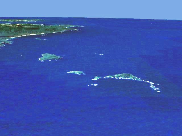
English: Aerial view of the southern coast of Tasmania. In the background South East Cape, in the foreground the Maatsuyker Islands (Needle Rocks are on the right; just to the left of them is Maatsuyker Island; De Witt is the larger island on the left). Artificial view generated from satellite data. |
| Datum | 22 juli 2006 (originele uploaddatum) |
| Bron | Verplaatst vanaf en.wikipedia naar Commons. |
| Auteur | De originele uploader was Phaedrus86 op de Engelstalige Wikipedia |
| Toestemming (Hergebruik van dit bestand) |
I extracted this image from en:NASA World Wind, which makes it public domain because of US Government policies. It is an artificial view generated from satellite data. --Phaedrus86 03:21, 22 July 2006 (UTC) |
Licentie
| Deze afbeelding bevindt zich in het publiek domein omdat het een screenshot is van NASA’s software World Wind die gebruik maakt van een publiek domein-laag, zoals Blue Marble, MODIS, Landsat, SRTM, USGS of GLOBE.
|
 |
Oorspronkelijk uploadlogboek
De oorspronkelijke beschrijving van deze afbeelding stond hier. Alle volgende gebruikersnamen verwijzen naar en.wikipedia.
- 2006-07-22 03:20 Phaedrus86 640×480×8 (16889 bytes) I extracted this image from [[Nasa Worldwind]]. It is an artificial view generated from satellite data.
Bestandsgeschiedenis
Klik op een datum/tijd om het bestand te zien zoals het destijds was.
| Datum/tijd | Miniatuur | Afmetingen | Gebruiker | Opmerking | |
|---|---|---|---|---|---|
| huidige versie | 1 apr 2007 09:30 | | 640 × 480 (39 kB) | Ibn Battuta | edited to increase contrast and hence visibility |
| 1 apr 2007 06:19 |  | 640 × 480 (16 kB) | Ibn Battuta | {{Information |Description=Aerial view of the southern coast of Tasmania. In the background South East Cape, in the foreground the Maatsuyker Islands (Needle Rocks are on the right; just to the left of th |
Bestandsgebruik
Dit bestand wordt op de volgende pagina gebruikt:
Globaal bestandsgebruik
De volgende andere wiki's gebruiken dit bestand:
- Gebruikt op ceb.wikipedia.org
- Gebruikt op de.wikipedia.org
- Gebruikt op en.wikipedia.org
- Gebruikt op eo.wikipedia.org
- Gebruikt op it.wikipedia.org
- Gebruikt op ru.wikipedia.org
- Gebruikt op uk.wikipedia.org
- Gebruikt op www.wikidata.org