Bestand:Locations of UMNH VP16420 & MSM P2117.png
Grootte van deze voorvertoning: 563 × 599 pixels. Andere resoluties: 225 × 240 pixels | 451 × 480 pixels | 722 × 768 pixels | 1.153 × 1.227 pixels.
Oorspronkelijk bestand (1.153 × 1.227 pixels, bestandsgrootte: 265 kB, MIME-type: image/png)
| Dit is een bestand van Wikimedia Commons. Onderstaande beschrijving komt van de beschrijving van het bestand daar. |
Beschrijving
| Beschrijving |
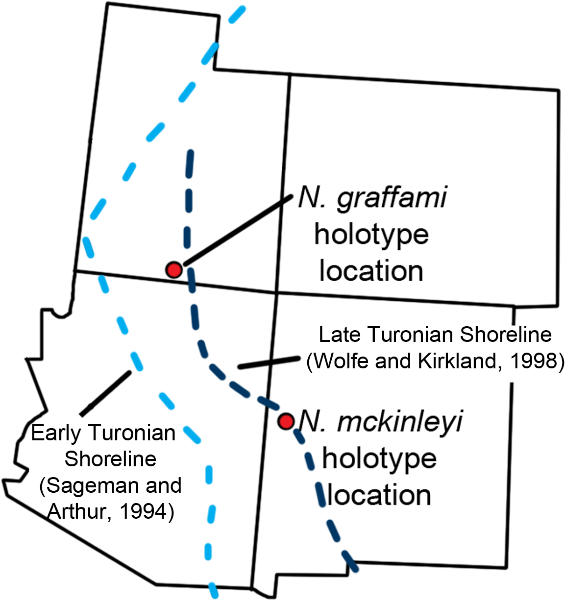
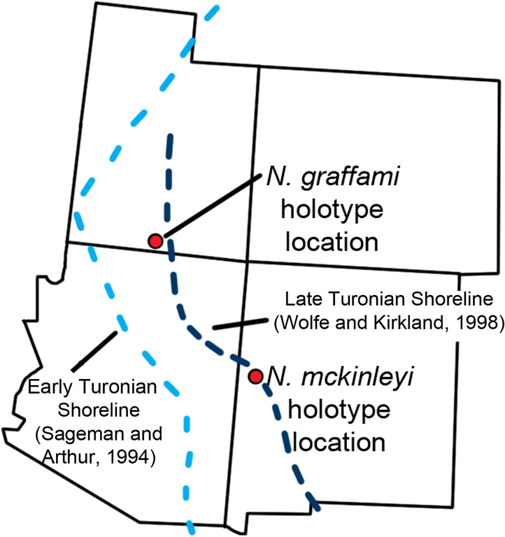
English: Location map. The locations of the quarries producing UMNH VP16420 and MSM P2117 with US states overlaid. This is in relation to the estimated Turonian shoreline (light blue shoreline based on Sageman and Arthur 1994; dark blue shoreline based on Wolfe and Kirkland 1998). The shoreline reconstructed by Sageman and Arthur 1994 is based on the early Turonian and that by Wolfe and Kirkland 1998 is for the late Turonian demonstrating a regression of the Western Interior Seaway during the Turonian. This shows that during the early Turonian UMNH VP16420 was offshore. |
||
| Datum | |||
| Bron | (2015). "The Slothful Claw: Osteology and Taphonomy of Nothronychus mckinleyi and N. graffami (Dinosauria: Theropoda) and Anatomical Considerations for Derived Therizinosaurids". PLOS ONE 10 (6): e0129449. DOI:10.1371/journal.pone.0129449. PMID 26061728. PMC: 4465624. | ||
| Auteur | Brandon P. Hedrick, Lindsay E. Zanno, Douglas G. Wolfe & Peter Dodson | ||
| Toestemming (Hergebruik van dit bestand) |
|
Licentie
Dit bestand is gelicenseerd onder de Creative Commons Naamsvermelding 4.0 Internationaal licentie.
- De gebruiker mag:
- Delen – het werk kopiëren, verspreiden en doorgeven
- Remixen – afgeleide werken maken
- Onder de volgende voorwaarden:
- naamsvermelding – U moet op een gepaste manier aan naamsvermelding doen, een link naar de licentie geven, en aangeven of er wijzigingen in het werk zijn aangebracht. U mag dit op elke redelijke manier doen, maar niet zodanig dat de indruk wordt gewekt dat de licentiegever instemt met uw werk of uw gebruik van zijn werk.
Bestandsgeschiedenis
Klik op een datum/tijd om het bestand te zien zoals het destijds was.
| Datum/tijd | Miniatuur | Afmetingen | Gebruiker | Opmerking | |
|---|---|---|---|---|---|
| huidige versie | 16 aug 2020 19:16 | | 1.153 × 1.227 (265 kB) | PaleoNeolitic | {{Information |description ={{en|1='''Location map.''' The locations of the quarries producing UMNH VP16420 and MSM P2117 with US states overlaid. This is in relation to the estimated Turonian shoreline (light blue shoreline based on Sageman and Arthur 1994; dark blue shoreline based on Wolfe and Kirkland 1998). The shoreline reconstructed by Sageman and Arthur 1994 is based on the early Turonian and that by Wolfe and Kirkland 1998 is for the late Turonian demonstrating a regression of the... |
Bestandsgebruik
Dit bestand wordt op de volgende pagina gebruikt:
Globaal bestandsgebruik
De volgende andere wiki's gebruiken dit bestand:
- Gebruikt op en.wikipedia.org
- Gebruikt op it.wikipedia.org