Bestand:Location map Rockall.jpg

Grootte van deze voorvertoning: 709 × 600 pixels. Andere resoluties: 284 × 240 pixels | 567 × 480 pixels | 908 × 768 pixels | 1.210 × 1.024 pixels | 1.300 × 1.100 pixels.
Oorspronkelijk bestand (1.300 × 1.100 pixels, bestandsgrootte: 857 kB, MIME-type: image/jpeg)
| Dit is een bestand van Wikimedia Commons. Onderstaande beschrijving komt van de beschrijving van het bestand daar. |
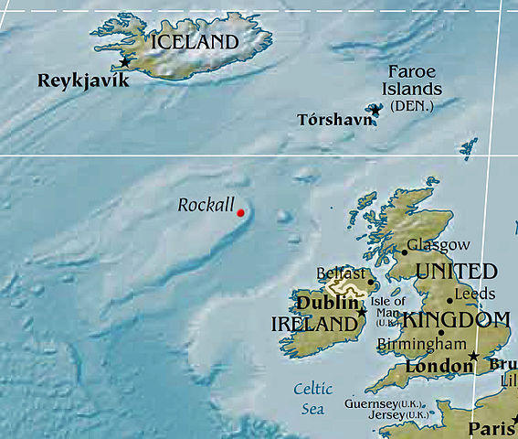
Map displaying the location of Rockall, based on a PD CIA world map. Political designations removed by Bjarki.
Deze afbeelding bevindt zich in het publiek domein omdat het materiaal bevat dat oorspronkelijk afkomstig is van het CIA World Factbook.
|
 |
Bestandsgeschiedenis
Klik op een datum/tijd om het bestand te zien zoals het destijds was.
| Datum/tijd | Miniatuur | Afmetingen | Gebruiker | Opmerking | |
|---|---|---|---|---|---|
| huidige versie | 8 feb 2016 04:02 | | 1.300 × 1.100 (857 kB) | Nagualdesign | Removed political designation ("UK"), since the area is disputed. |
| 28 dec 2015 07:32 |  | 1.300 × 1.100 (855 kB) | Nagualdesign | Updated (better resolution) using CIA map. | |
| 23 apr 2005 15:34 |  | 615 × 520 (119 kB) | Bjarki S | Map displaying the location of Rockall, based on a PD CIA world map. Political designations removed by Bjarki. {{PD-USGov-CIA-WF}} |
Bestandsgebruik
Dit bestand wordt op de volgende 2 pagina's gebruikt:
Globaal bestandsgebruik
De volgende andere wiki's gebruiken dit bestand:
- Gebruikt op br.wikipedia.org
- Gebruikt op cs.wikipedia.org
- Gebruikt op de.wikipedia.org
- Gebruikt op en.wikipedia.org
- Gebruikt op eu.wikipedia.org
- Gebruikt op fy.wikipedia.org
- Gebruikt op id.wikipedia.org
- Gebruikt op is.wikipedia.org
- Gebruikt op ko.wikipedia.org
- Gebruikt op nn.wikipedia.org
- Gebruikt op pnb.wikipedia.org
- Gebruikt op sr.wikipedia.org
- Gebruikt op sv.wikipedia.org
- Gebruikt op tr.wikipedia.org
- Gebruikt op vi.wikipedia.org
- Gebruikt op www.wikidata.org