Bestand:Location Chile Capitania.png
Geen hogere resolutie beschikbaar.
Location_Chile_Capitania.png (250 × 115 pixels, bestandsgrootte: 10 kB, MIME-type: image/png)
Dit is een bestand van Wikimedia Commons.
Onderstaande beschrijving komt van de beschrijving van het bestand daar.
Onderstaande beschrijving komt van de beschrijving van het bestand daar.
Beschrijving
| Beschrijving |
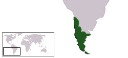
English: Map of the occupied and claimed territories of the Captaincy General of Chile, according to Chilean historiography.
IMPORTANT NOTE: Patagonian territories were never an effective part of the Captaincy, and according to 1570 Royal Decree the rights on the Eastern Patagonia belonged to the Rio de la Plata Province (Viceroyalty of Peru, later Viceroyalty of the Rio de la Plata), a situation not considered in Chilean historiography. Español: Mapa de los territorios ocupados y reclamados por la Capitanía General de Chile, según historiografía chilena. NOTA IMPORTANTE: los territorios patagónicos nunca formaron parte efectiva de la Capitanía, mientras que la Patagonia Oriental de acuerdo a la Real Cédula de 1570 correspondía de derecho a la Provincia del Río de la Plata (Virreinato del Perú, posteriormente Virreinato del Río de la Plata) situación no considerada en la historiografía chilena. |
||
| Bron | Eigen werk | ||
| Auteur | KRATK | ||
| Toestemming (Hergebruik van dit bestand) |
|
Bestandsgeschiedenis
Klik op een datum/tijd om het bestand te zien zoals het destijds was.
| Datum/tijd | Miniatuur | Afmetingen | Gebruiker | Opmerking | |
|---|---|---|---|---|---|
| huidige versie | 15 nov 2022 03:11 | | 250 × 115 (10 kB) | Janitoalevic | Con Cuyo |
| 24 feb 2009 00:35 |  | 250 × 115 (10 kB) | Dexxter | Reverted to version as of 23:15, 26 June 2005 | |
| 8 okt 2005 00:26 |  | 250 × 115 (7 kB) | B1mbo | Mapa aproximado de la ubicación y extensión de la Capitanía General de Chile | |
| 27 jun 2005 01:15 |  | 250 × 115 (10 kB) | B1mbo | Ubicación de la Capitanía General de Chile {{PD}} |
Bestandsgebruik
Geen enkele pagina gebruikt dit bestand.