Bestand:Livingston-Island-Map-2010-15.png
Grootte van deze voorvertoning: 799 × 600 pixels. Andere resoluties: 320 × 240 pixels | 640 × 480 pixels | 1.023 × 768 pixels | 1.280 × 961 pixels | 2.560 × 1.922 pixels | 5.337 × 4.006 pixels.
Oorspronkelijk bestand (5.337 × 4.006 pixels, bestandsgrootte: 9,65 MB, MIME-type: image/png)
| Dit is een bestand van Wikimedia Commons. Onderstaande beschrijving komt van de beschrijving van het bestand daar. |
Beschrijving
| Beschrijving |
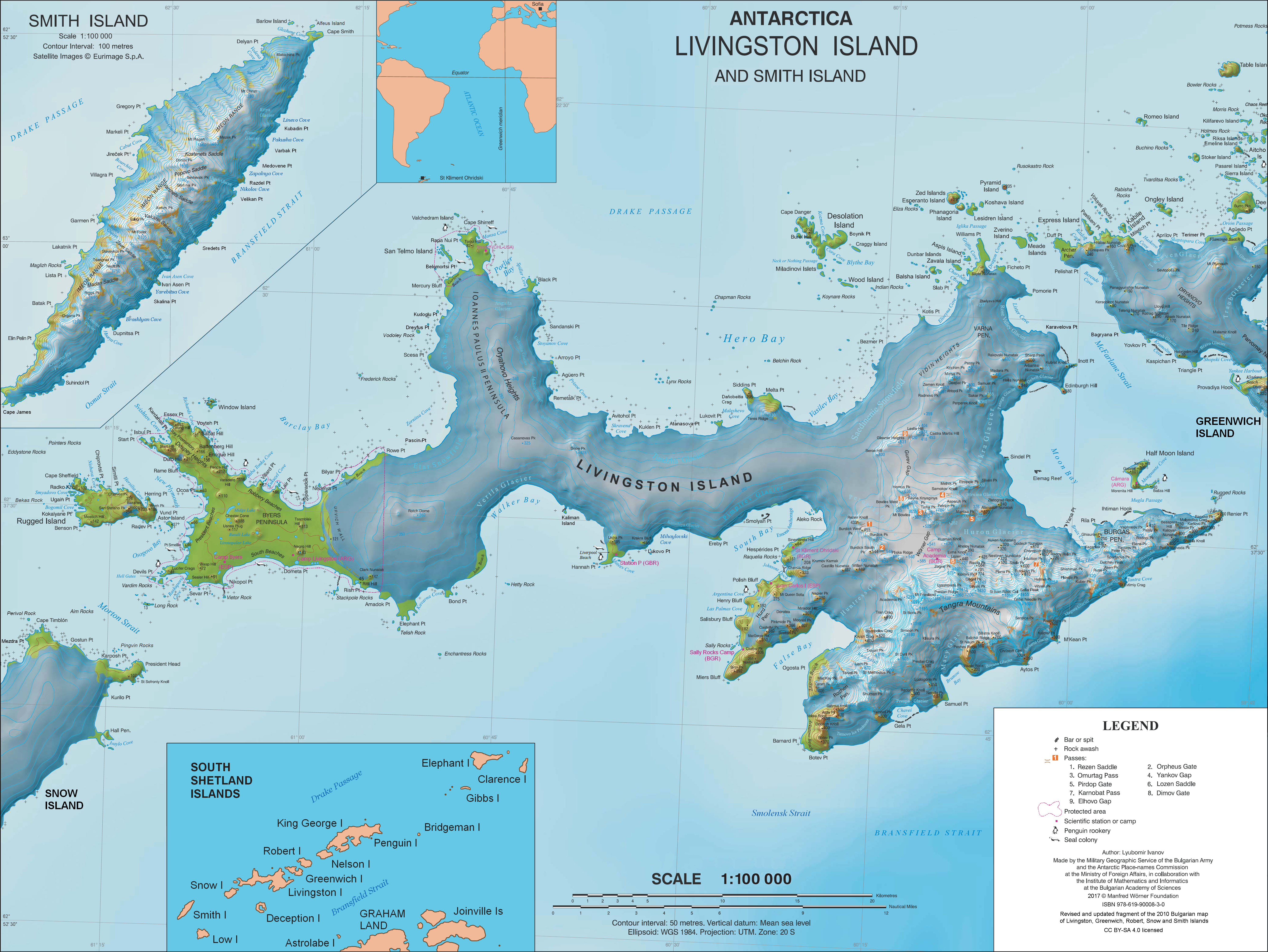
English: L.L. Ivanov. Antarctica: Livingston Island and Smith Island. Scale 1:100000 topographic map. Manfred Wörner Foundation, 2017. ISBN 978-619-90008-3-0 |
| Datum | |
| Bron | Eigen werk |
| Auteur | Apcbg |
| Toestemming (Hergebruik van dit bestand) |
Published by the Manfred Wörner Foundation under the Creative Commons Attribution ShareAlike 4.0 license. |
| Andere versies | File:Livingston-Island-Map-2010.jpg, an earlier version |
Licentie
Ik, de auteursrechthebbende van dit werk, maak het hierbij onder de volgende licentie beschikbaar:
Dit bestand is gelicenseerd onder de Creative Commons Naamsvermelding-GelijkDelen 4.0 Internationaal licentie.
- De gebruiker mag:
- Delen – het werk kopiëren, verspreiden en doorgeven
- Remixen – afgeleide werken maken
- Onder de volgende voorwaarden:
- naamsvermelding – U moet op een gepaste manier aan naamsvermelding doen, een link naar de licentie geven, en aangeven of er wijzigingen in het werk zijn aangebracht. U mag dit op elke redelijke manier doen, maar niet zodanig dat de indruk wordt gewekt dat de licentiegever instemt met uw werk of uw gebruik van zijn werk.
- Gelijk delen – Als u het werk heeft geremixt, veranderd, of erop heeft voortgebouwd, moet u het gewijzigde materiaal verspreiden onder dezelfde licentie als het oorspronkelijke werk, of een daarmee compatibele licentie.
Bestandsgeschiedenis
Klik op een datum/tijd om het bestand te zien zoals het destijds was.
| Datum/tijd | Miniatuur | Afmetingen | Gebruiker | Opmerking | |
|---|---|---|---|---|---|
| huidige versie | 2 apr 2021 12:28 | | 5.337 × 4.006 (9,65 MB) | Apcbg | update |
| 27 jun 2019 15:21 |  | 5.337 × 4.006 (9,65 MB) | Apcbg | minor update | |
| 23 mei 2019 14:21 |  | 5.337 × 4.006 (9,65 MB) | Apcbg | update | |
| 19 mrt 2019 10:22 |  | 5.337 × 4.006 (9,65 MB) | Apcbg | minor update | |
| 9 feb 2019 23:14 |  | 5.337 × 4.006 (9,66 MB) | Apcbg | Update | |
| 5 feb 2019 17:35 |  | 5.337 × 4.006 (9,66 MB) | Apcbg | Minor | |
| 2 feb 2019 21:20 |  | 5.337 × 4.006 (9,66 MB) | Apcbg | Update | |
| 9 aug 2018 08:44 |  | 5.337 × 4.006 (9,66 MB) | Apcbg | Update | |
| 8 aug 2018 08:17 |  | 5.337 × 4.006 (9,66 MB) | Apcbg | Update | |
| 31 mrt 2017 13:38 |  | 5.337 × 4.006 (10,92 MB) | Apcbg | Updated topography and toponymy |
Bestandsgebruik
Dit bestand wordt op de volgende 2 pagina's gebruikt:
Globaal bestandsgebruik
De volgende andere wiki's gebruiken dit bestand:
- Gebruikt op ar.wikipedia.org
- Gebruikt op ast.wikipedia.org
- Gebruikt op az.wikipedia.org
- Gebruikt op bg.wikipedia.org
- Свети Климент Охридски (база)
- Ливингстън (остров)
- Тангра (планина)
- Монтана (връх)
- Академия (връх)
- Айтос (нос)
- Авитохол (нос)
- Цариград (връх)
- Лясковец (връх)
- Фрисланд (връх)
- Видински възвишения
- Куцото куче
- Свети Борис (връх)
- Симеон (връх)
- Варна (полуостров)
- Свети Иван Рилски (рид)
- Потребител:Dafosaddikk/Скала Белчин
- Скала Белчин
- Gebruikt op ca.wikipedia.org
- Gebruikt op ceb.wikipedia.org
- Gebruikt op de.wikipedia.org
- Livingston-Insel
- Table Island (Südliche Shetlandinseln)
- Barclay Bay
- Kap Shirreff
- Johannes-Paul-II.-Halbinsel
- Hero Bay
- Desolation Island (Südliche Shetlandinseln)
- Burdick Peak
- Black Point (Livingston-Insel)
- Blythe Bay
- Hemus Peak
- Leslie Hill (Livingston-Insel)
- Brunow Bay
- Bravo-Gletscher
- McFarlane Strait
- Renier Point
- Burdick South Peak
- Burdick West Peak
- Willan-Nunatak
- Plíska Ridge
- Rotch Dome
- Cora Cove
- Craggy Island (Südliche Shetlandinseln)
Globaal gebruik van dit bestand bekijken.