Bestand:LA County Incorporated Areas.svg

Afmetingen van deze voorvertoning van het type PNG van dit SVG-bestand: 730 × 599 pixels Andere resoluties: 292 × 240 pixels | 585 × 480 pixels | 935 × 768 pixels | 1.247 × 1.024 pixels | 2.494 × 2.048 pixels | 950 × 780 pixels.
Oorspronkelijk bestand (SVG-bestand, nominaal 950 × 780 pixels, bestandsgrootte: 261 kB)
| Dit is een bestand van Wikimedia Commons. Onderstaande beschrijving komt van de beschrijving van het bestand daar. |
Beschrijving
| Beschrijving |
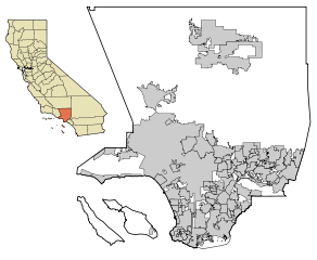
This map shows all the incorporated areas (cities) within Los Angeles County, in Southern California. I created it in Inkscape using data from the Los Angeles County Website (Los Angeles County Incorporated Area and District Map (PDF). |
| Datum | |
| Bron | My own work, based on public domain information. Though I strove to be as accurate in the detail as possible, the information shown is not guaranteed to be completely accurate. |
| Auteur | Ixnayonthetimmay |
| Toestemming (Hergebruik van dit bestand) |
Public Domain |
| Andere versies | See Category:Maps of Los Angeles County, California for other versions of this image. |
Licentie
| Ik, de auteursrechthebbende van dit werk, geef dit werk vrij in het publieke domein. Dit is wereldwijd van toepassing. In sommige landen is dit wettelijk niet mogelijk; in die gevallen geldt: Ik sta iedereen toe dit werk voor eender welk doel te gebruiken, zonder enige voorwaarden, tenzij zulke voorwaarden door de wet worden voorgeschreven. |
Bestandsgeschiedenis
Klik op een datum/tijd om het bestand te zien zoals het destijds was.
| Datum/tijd | Miniatuur | Afmetingen | Gebruiker | Opmerking | |
|---|---|---|---|---|---|
| huidige versie | 18 jun 2007 00:36 | | 950 × 780 (261 kB) | Ixnayonthetimmay | == Summary == {{Information |Description=This map shows the incorporated areas in Los Angeles County, California. I created it in Inkscape using data from the L |
Bestandsgebruik
Dit bestand wordt op de volgende pagina gebruikt:
Globaal bestandsgebruik
De volgende andere wiki's gebruiken dit bestand:
- Gebruikt op az.wikipedia.org
- Gebruikt op en.wikipedia.org
- Gebruikt op eo.wikipedia.org
- Gebruikt op es.wikipedia.org
- Gebruikt op et.wikipedia.org
- Gebruikt op fa.wikipedia.org
- Gebruikt op fr.wikipedia.org
- Gebruikt op he.wikipedia.org
- Gebruikt op hsb.wikipedia.org
- Gebruikt op id.wikipedia.org
- Gebruikt op lv.wikipedia.org
- Gebruikt op pam.wikipedia.org
- Gebruikt op pt.wikipedia.org
- Gebruikt op ru.wikipedia.org
- Gebruikt op tr.wikipedia.org
- Gebruikt op vi.wikipedia.org