Bestand:Kiribati location map.svg

Oorspronkelijk bestand (SVG-bestand, nominaal 1.488 × 673 pixels, bestandsgrootte: 68 kB)
| Dit is een bestand van Wikimedia Commons. Onderstaande beschrijving komt van de beschrijving van het bestand daar. |
Beschrijving
| Beschrijving |
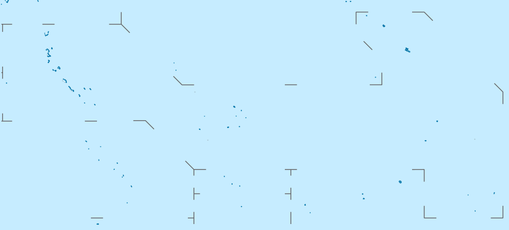
Deutsch: Positionskarte von Kiribati
Quadratische Plattkarte. Geographische Begrenzung der Karte:
English: Location map of Kiribati
Equirectangular projection. Geographic limits of the map:
|
|
| Datum | ||
| Bron |
Eigen werk, using
|
|
| Auteur | NordNordWest | |
| Toestemming (Hergebruik van dit bestand) |
Dit bestand is gelicenseerd onder de Creative Commons-licentie Naamsvermelding-Gelijk delen 3.0 Duitsland
 Dit bestand is gelicenseerd onder de Creative Commons-licentie Naamsvermelding-Gelijk delen 3.0 Duitsland
|
|
| Andere versies |
|


|
Deze kaart is gemaakt of verbeterd in de Duitse Kartenwerkstatt (Map Lab). Je kunt ook zelf kaarten ter verbetering voorstellen.
|
Bestandsgeschiedenis
Klik op een datum/tijd om het bestand te zien zoals het destijds was.
| Datum/tijd | Miniatuur | Afmetingen | Gebruiker | Opmerking | |
|---|---|---|---|---|---|
| huidige versie | 23 feb 2021 17:52 | | 1.488 × 673 (68 kB) | NordNordWest | Reverted to version as of 09:54, 1 April 2010 (UTC), sorry, but this is not location map style |
| 23 feb 2021 15:08 |  | 1.488 × 673 (137 kB) | Amitchell125 | borders made visible with minor corrections | |
| 1 apr 2010 11:54 |  | 1.488 × 673 (68 kB) | NordNordWest | c | |
| 5 mrt 2010 22:04 |  | 1.488 × 673 (84 kB) | NordNordWest | == {{int:filedesc}} == {{Information |Description= {{de|Positionskarte von Kiribati}} Quadratische Plattkarte. Geographische Begrenzung der Karte: * N: 6° N * S: 13° S * W: 169° O * O: 149° W {{en|Location map of [[:en:Kiribati|Kiriba |
Bestandsgebruik
Dit bestand wordt op de volgende 16 pagina's gebruikt:
Globaal bestandsgebruik
De volgende andere wiki's gebruiken dit bestand:
- Gebruikt op af.wikipedia.org
- Gebruikt op als.wikipedia.org
- Gebruikt op an.wikipedia.org
- Gebruikt op ar.wikipedia.org
- Gebruikt op ast.wikipedia.org
- Gebruikt op az.wikipedia.org
- Gebruikt op ba.wikipedia.org
- Gebruikt op be-tarask.wikipedia.org
- Gebruikt op be.wikipedia.org
- Gebruikt op bg.wikipedia.org
- Gebruikt op bh.wikipedia.org
- Gebruikt op bn.wikipedia.org
- Gebruikt op bs.wikipedia.org
- Gebruikt op ceb.wikipedia.org
Globaal gebruik van dit bestand bekijken.